Mine Index Number: 2630
| Company Name:
|
River Bank Coal Company
|
| Mine Name:
|
River Bank Mine
|
| Start Date:
|
1881
|
End Date:
|
1886
|
| Type of Mine:
|
Underground
|
| Total acres shown:
|
25
|
| Acres after map date:
|
|
General Area of mining acres shown:
|
|
|
|
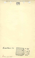
Shaft, Slope, Drift or Tipple Location(s)
| Type
|
County
|
Township-Range
|
Section
|
Part Section
|
| Main shaft
|
La Salle
|
31N 3E
|
35
|
NE SE NE
|
Geology
Geological Problems Reported
Production
| Company
|
Mine Name
|
Date
|
Production (tons)
|
|
|
|
|
|
| Total Production: 118,743
|
Production Notes
Coal Report production (if available)
Sources of Data
| Microfilm, mines087.tif and mines088.tif
|
Undated
|
Unknown
|
1:4248
|
Secondary source
|
| Mine notes
|
Undated
|
1:62500
|
1:24000The mine location was plotted on a 1:24000 USGS topographic map from the mine location description and digitized.
|
Secondary source
|
Annotated Bibliography (Data source - brief description of information)
| Coal Reports - Production, ownership, years of operation, depth, thickness.
|
| Directory of Illinois Coal Mines (La Salle County) - Mine names, mine index, ownership, years of operation.
|
| Mine notes (La Salle County) - Shaft location.
|
| Microfilm map, Coal Section files, mines087.tif & mines088.tif - Mine outline, mining method.
|
Mine Notes
Mine Images
Photographs