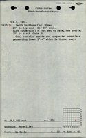
Mine Index Number: 2696
| Company Name:
|
Smith Brothers
|
| Mine Name:
|
Smith Mine
|
| Start Date:
|
1933
|
End Date:
|
1934
|
| Type of Mine:
|
Underground
|
| Total acres shown:
|
None
|
| Production Indicated Acres:
|
less than 1
|
General Area of mining acres shown:
|
|
|
|
Shaft, Slope, Drift or Tipple Location(s)
| Type
|
County
|
Township-Range
|
Section
|
Part Section
|
| Mine
|
La Salle
|
33N 4E
|
10
|
SE NW SE
|
Geology
| Colchester
|
89
|
|
|
2.2-2.5
|
Underground
|
Geological Problems Reported
Production
| Company
|
Mine Name
|
Date
|
Production (tons)
|
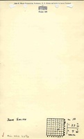
| Sam Smith
|
Smith
|
1933-1933Field notes written in 1931 indicate the mine was active before reported production. Production was not reported for mines producing less than 1,000 tons per year from 1930 to 1933.
|
1,000
|
|
|
Production Notes
Coal Report production (if available)
Sources of Data
| ISGS field notes (H. B. Wilman)
|
1931
|
1:62500
|
1:24000The mine location was plotted on a 1:24000 USGS topographic map from the mine location description and digitized.
|
Secondary source
|
Annotated Bibliography (Data source - brief description of information)
| Coal Reports - Production, ownership, years of operation, mine type.
|
| Directory of Illinois Coal Mines (La Salle County) - Mine names, mine index, ownership, years of operation.
|
| Mine notes (La Salle County) - Mine location.
|
| ISGS field notes (La Salle County) - Mine location, depth, thickness, geologic problems.
|
Mine Notes
Mine Images
Photographs