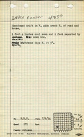
Mine Index Number: 4850
| Company Name:
|
Unknown
|
| Mine Name:
|
Unknown Mine
|
| Start Date:
|
Before 1916
|
End Date:
|
Before 1932
|
| Type of Mine:
|
Underground
|
| Total acres shown:
|
None
|
| Acres after map date:
|
|
General Area of mining acres shown:
|
|
|
|
Shaft, Slope, Drift or Tipple Location(s)
| Type
|
County
|
Township-Range
|
Section
|
Part Section
|
| Slope
|
Johnson
|
11S 3E
|
32
|
NE SW SW
|
Geology
Geological Problems Reported
Production
| Company
|
Mine Name
|
Date
|
Production (tons)
|
Production Notes
Coal Report production (if available)
Sources of Data
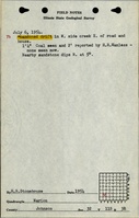
| Mine notes (H. B. Stonehouse)
|
7-6-1954
|
1:62500
|
1:62500
|
Secondary source
|
| ISGS field notes (A. D. Brokaw)
|
1916
|
1:62500
|
1:62500
|
Secondary source
|
| ISGS field notes (M. W. Fuller and J. M. Weller)
|
8-20-1933
|
1:62500
|
1:62500
|
Secondary source
|
Annotated Bibliography (Data source - brief description of information)
| Mine notes (Johnson County) - Mine type, mine location, thickness.
|
| ISGS field notes (Johnson County) - Mine location.
|
| ISGS field notes (Johnson County) - Mine type, mine location, thickness.
|
Mine Notes
Mine Images
Photographs