Mine Index Number: 6321
| Company Name:
|
|
| Mine Name:
|
|
| Start Date:
|
Circa 1860
|
End Date:
|
Unknown
|
| Type of Mine:
|
Underground
|
| Total acres shown:
|
|
| Acres after map date:
|
|
General Area of mining acres shown:
|
|
|
Not Shown On Map. Not shown on accompanying map due to later surface mining by Midland Mine (mine index 681).
|
Shaft, Slope, Drift or Tipple Location(s)
| Type
|
County
|
Township-Range
|
Section
|
Part Section
|
| Shaft
|
Bureau
|
16N 6E
|
20
|
NE NE SE
|
Geology
| Herrin
|
50-60
|
|
|
3.5
|
Underground
|
Geological Problems Reported
Production
| Company
|
Mine Name
|
Date
|
Production (tons)
|
Production Notes
Coal Report production (if available)
Sources of Data
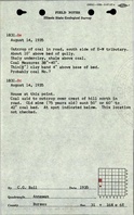
| ISGS field notes (C. G. Ball)
|
8-14-1935
|
1:62500
|
1:62500
|
Secondary source
|
Annotated Bibliography (Data source - brief description of information)
| ISGS field notes (Bureau County) - Shaft location, mine type, seam, depth, thickness, approximate date of operation.
|
Mine Notes
Mine Images
Photographs