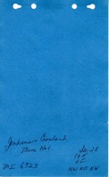
Mine Index Number: 6323
| Company Name:
|
Jenkins and Crosland
|
| Mine Name:
|
Jenkins and Crosland No. 1 Mine
|
| Start Date:
|
1932
|
End Date:
|
1937
|
| Type of Mine:
|
Underground
|
| Total acres shown:
|
None Production indicates approximately 2 acres were mined.
|
| Acres after map date:
|
|
General Area of mining acres shown:
|
|
|
|
Shaft, Slope, Drift or Tipple Location(s)
| Type
|
County
|
Township-Range
|
Section
|
Part Section
|
| Main shaft
|
Bureau
|
16N 6E
|
28
|
NW NE NW
|
Geology
| Herrin
|
50-60
|
|
|
4.5-5.0
|
Underground
|
Geological Problems Reported
Production
| Company
|
Mine Name
|
Date
|
Production (tons)
|
Production Notes
Coal Report production (if available)
Sources of Data
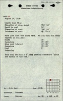
| ISGS field notes (C. G. Ball)
|
8-14-1935
|
(text only)
|
1:24000 Point plotted onto 1:24,000 USGS topographic map and digitized.
|
Secondary source
|
Annotated Bibliography (Data source - brief description of information)
| Coal Reports - Production, ownership, years of operation.
|
| Directory of Illinois Coal Mines (Bureau County) - Mine names, mine index, ownership, years of operation.
|
| Mine notes (Bureau County) - Mine type, shaft location, seam.
|
| ISGS field notes (Bureau County) - Shaft location, depth, thickness.
|
| Federal Land Bank Report (Bureau County) - Depth.
|
Mine Notes
Mine Images
Photographs