Mine Index Number: 6335
| Company Name:
|
P. C. Nelson
|
| Mine Name:
|
Nelson Mine
|
| Start Date:
|
1903
|
End Date:
|
1910
|
| Type of Mine:
|
Underground
|
| Total acres shown:
|
None
|
| Production Indicated Acres:
|
3
|
General Area of mining acres shown:
|
|
|
|
Shaft, Slope, Drift or Tipple Location(s)
| Type
|
County
|
Township-Range
|
Section
|
Part Section
|
| Shaft
|
Bureau
|
16N 6E
|
26
|
NE NE
|
Geology
Geological Problems Reported
Production
| Company
|
Mine Name
|
Date
|
Production (tons)
|
Production Notes
Coal Report production (if available)
Sources of Data
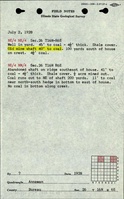
| ISGS field notes
|
7-2-1928
|
1:62500
|
1:62500
|
Secondary source
|
| Federal Land Bank Report
|
6-1935
|
1:126720
|
1:126720
|
Secondary source
|
Annotated Bibliography (Data source - brief description of information)
| Coal Reports - Production, ownership, years of operation, mine tpe, seam, depth, thickness, mining method.
|
| Directory of Illinois Coal Mines (Bureau County) - Mine names, mine index, ownership, years of operation.
|
| ISGS field notes (Bureau County) - Shaft location, depth, thickness.
|
| Federal Land Bank Report (Bureau County) - Shaft location, mine ownership.
|
Mine Notes
Mine Images
Photographs