Mine Index Number: 6340
| Company Name:
|
|
| Mine Name:
|
|
| Start Date:
|
before 1927
|
End Date:
|
Unknown
|
| Type of Mine:
|
Underground
|
| Total acres shown:
|
|
| Acres after map date:
|
|
General Area of mining acres shown:
|
|
|
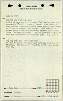
The location is questionable. The location was derived from the log of field work handwritten by G. H. Cady, with this location missing the section number. Cady wrote "This mine is at lowest point along two east-west section line roads." An E-W section line might put the mine at NW NW NW if the mine is in Section 30.
|
Shaft, Slope, Drift or Tipple Location(s)
| Type
|
County
|
Township-Range
|
Section
|
Part Section
|
| Slope
|
Bureau
|
16N 6E
|
30 The original field notes did not list the section and the location was derived and is probably incorrect.
|
SW SW NW
|
Geology
| Herrin
|
25
|
|
|
5.0
|
Underground
|
Geological Problems Reported
Production
| Company
|
Mine Name
|
Date
|
Production (tons)
|
Production Notes
Coal Report production (if available)
Sources of Data
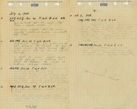
| ISGS field notes (G. H. Cady)
|
7-2-1928
|
1:62500
|
1:62500
|
Secondary source
|
Annotated Bibliography (Data source - brief description of information)
| ISGS field notes (Bureau County) - Mine type, mine location, depth, thickness.
|
Mine Notes
Mine Images
Photographs