Mine Index Number: 6725
| Company Name:
|
Charles Taylor
|
| Mine Name:
|
Taylor Mine
|
| Start Date:
|
1914
|
End Date:
|
1928
|
| Type of Mine:
|
Underground
|
| Total acres shown:
|
None
|
| Production Indicated Acres:
|
2
|
General Area of mining acres shown:
|
|
|
|
Shaft, Slope, Drift or Tipple Location(s)
| Type
|
County
|
Township-Range
|
Section
|
Part Section
|
| Drift
|
Scott
|
15N 12W
|
26
|
NE SE NE
|
Geology
Geological Problems Reported
Production
| Company
|
Mine Name
|
Date
|
Production (tons)
|
Production Notes
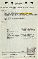
A. H. Bell, 9-13-1927, for Taylor's coal mine, probably drift, 20" thick, @ 1f (ne se ne) 26-15n-13w and then the 2nd page is G. H. Cady, 1916, nw ne 25-13n-12w, Charles Taylor "near Exeter" -- but Exeter is 15n-12w, 28-30" thick. T13N is therefore incorrect from Cady's field note, and R13W is incorrect from Bell's field note. I used Bell's location of NE SE NE section 26, but the mine could be in the Winchester Quadrangle in NW NE section 25.
Coal Report production (if available)
Sources of Data
| ISGS field notes (A. H. Bell)
|
9-13-1927
|
1:62500
|
1:62500
|
Secondary source
|
Annotated Bibliography (Data source - brief description of information)
| Coal Reports - Production, ownership, years of operation, mine type, seam, depth, thickness, mining method.
|
| Directory of Illinois Coal Mines (Scott County) - Mine names, mine index, ownership, years of operation, seam.
|
| ISGS field notes (Scott County) - Drift location.
|
Mine Notes
Mine Images
Photographs