Mine Index Number: 6739
| Company Name:
|
William Hausenkamp
|
| Mine Name:
|
Hausenkamp Mine
|
| Start Date:
|
1935
|
End Date:
|
1935
|
| Type of Mine:
|
Underground
|
| Total acres shown:
|
None
|
| Production Indicated Acres:
|
Less than 1
|
General Area of mining acres shown:
|
|
|
|
Shaft, Slope, Drift or Tipple Location(s)
| Type
|
County
|
Township-Range
|
Section
|
Part Section
|
| Main drift
|
Scott
|
15N 12W
|
20
|
NE SW NW or NW SE NW
|
Geology
| Colchester
|
|
|
|
2.0
|
Underground
|
Geological Problems Reported
Production
| Company
|
Mine Name
|
Date
|
Production (tons)
|
Production Notes
The location is from field notes dated 1927, while production is from 1935 only. The Coal Reports did not list production from 1930 to 1934 for mines producing less than 1,000 tons per year. It is possible that the inspectors missed collecting information from the Hausenkamp Mine in the late 1920s, as no other Hausenkamp Mines were listed in the Coal Reports. However, it is possible that the production listed above does not correspond to the location shown at the top of the page.
Coal Report production (if available)
Sources of Data
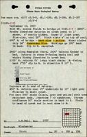
| ISGS field notes (A. H. Bell)
|
9-10-1927
|
1:62500
|
1:62500
|
Secondary source
|
Annotated Bibliography (Data source - brief description of information)
| Coal Reports - Production, ownership, years of operation.
|
| Directory of Illinois Coal Mines (Scott County) - Mine names, mine index, ownership, years of operation, seam.
|
| ISGS field notes (Scott County) - Mine location, mine type, thickness.
|
Mine Notes
Mine Images
Photographs