Mine Index Number: 7813
| Company Name:
|
Noah Hodgett
|
| Mine Name:
|
Hodgett Mine
|
| Start Date:
|
1902
|
End Date:
|
1903
|
| Type of Mine:
|
Underground
|
| Total acres shown:
|
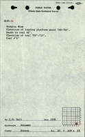
7 The mine is too large for the reported production. It is likely that production was listed under other names. See the unlocated mines in Bureau County, most likely with an address of Mineral.
|
| Acres after map date:
|
|
General Area of mining acres shown:
|
|
|
Not Shown On Map. The area was later surface mined by Midland Mine (mine index 681).
|
Shaft, Slope, Drift or Tipple Location(s)
| Type
|
County
|
Township-Range
|
Section
|
Part Section
|
| Shaft
|
Bureau
|
16N 6E
|
20
|
NE SE SE
|
Geology
Geological Problems Reported
Production
| Company
|
Mine Name
|
Date
|
Production (tons)
|
Production Notes
Coal Report production (if available)
Sources of Data
| Microfilm, document 351376
|
1-24-1921
|
1:1200
|
1:1200
|
Secondary source
|
| Federal Land Bank Report
|
6-1935
|
1:126720
|
1:126720
|
Secondary source
|
Annotated Bibliography (Data source - brief description of information)
| Coal Reports - Production, ownership, years of operation, seam, depth, thickness, mining method.
|
| Directory of Illinois Coal Mines (Bureau County) - Mine names, mine index, ownership, years of operation.
|
| Microfilm map, document 351376, reel 03135, frame 414 (map of Barrowman Mine, mine index 6320) - Shaft locations, mine outline, mining method.
|
| Federal Land Bank Report (Bureau County) - Mine ownership.
|
Mine Notes
Mine Images
Photographs
![[[:Barrowman|Barrowman]]](https://wikiimage.isgs.illinois.edu/ilmines/bureau/thumbnails/m6320_351373_geo_th.jpg)