Columbia Quadrangle
Mining in the Columbia Quadrangle
Mining in Monroe County was undocumented by the Coal Reports for many years. The 1899 Coal Report stated that the coal was 3 feet thick and found at Columbia and New Hanover, but that it had “not been worked for two and a half years”. The number of mines that would have been in operation is not known, as they were never listed in the production tables of the relevant years of the Coal Reports. According to the Worthen report (1873), Snyder’s land in SE 27-T1S-R9W “has been worked in a small way for several years” (St. Clair County) and Gall’s coal mines in NW 3-T2S-R10W had been worked more extensively than any others, “though others have been opened at various points and after being worked for a short time have been abandoned”. This also happened in the Great Depression, as the Coal Report of 1932 indicated 7 mines produced a total of 4,232 tons, and in 1933, 2 mines produced a total of 505 tons. (Individual mines producing less than 1,000 tons per year were not listed.) It is obvious that mines operated here that were not recorded, but most would be of small extent and limited periods of operation. The coal was generally what is referred to as “pocket coal”, a coal with a very local distribution, often a small lense that pinches out in a very short distance. The coal was mined from the surface in stream beds, via drift entrances into hillsides and from shafts.
The Pickett Mine (mine index 2999) operated for 6 years and has a known location, but no maps of the mine are known to be in existence. Taylor Mine was known to have operated (John Taylor was the last of three operators working for one year each), but there are two locations known as Taylor Mine (mine indexes 7582 and 7583).
Map and Directory PDF Download
Coal Mines In Illinois Columbia Quadrangle
Mines that Appear on the Columbia Quadrangle
Unlocated Mines
Monroe County
St. Clair County
Pages in category "Columbia Quadrangle"
The following 15 pages are in this category, out of 15 total.
Media in category "Columbia Quadrangle"
The following 13 files are in this category, out of 13 total.
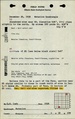
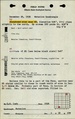
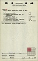
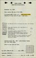
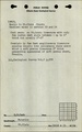
 M2999 minenotes.pdf 733 × 1,193, 3 pages; 605 KB
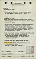
 M7582 fieldnotes.pdf 747 × 1,191; 238 KB
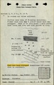
 M7583 fieldnotes.pdf 747 × 1,193, 2 pages; 370 KB
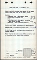
 M7584 fieldnotes.pdf 747 × 1,191; 232 KB
 M7585 fieldnotes.pdf 747 × 1,191; 231 KB
 M7586 fieldnotes.pdf 747 × 1,191; 231 KB
 M7587 fieldnotes.pdf 752 × 1,195; 205 KB
 M7588 fieldnotes.pdf 747 × 1,193; 248 KB
 M7589 fieldnotes.pdf 747 × 1,193; 178 KB
 M7590 fieldnotes.pdf 747 × 1,195; 257 KB
 M7591 fieldnotes.pdf 752 × 1,185, 2 pages; 432 KB
 M7592 fieldnotes.pdf 760 × 1,206; 603 KB
 M7593 fieldnotes.pdf 747 × 1,193; 189 KB