Mine Index Number: 7583
| Company Name:
|
New Hanover Coal Company
|
| Mine Name:
|
Taylor Mine
|
| Start Date:
|
Before 1928
|
End Date:
|
Unknown
|
| Type of Mine:
|
Underground
|
| Total acres shown:
|
None
|
| Acres after map date:
|
|
General Area of mining acres shown:
|
|
|
|
Shaft, Slope, Drift or Tipple Location(s)
| Type
|
County
|
Township-Range
|
Section
|
Part Section
|
| Shaft
|
Monroe
|
2S 10W
|
4
|
SE NE NE
|
Geology
Geological Problems Reported
Production
| Company
|
Mine Name
|
Date
|
Production (tons)
|
Production Notes
Coal Report production (if available)
Sources of Data
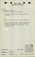
| ISGS field notes (H. R. Wanless)
|
8-23-1931
|
(text only)
|
1:24000 The mine location was plotted on a 1:24000 USGS topographic map from the mine location description and digitized.
|
Secondary source
|
| ISGS field notes (G. H. Cady)
|
12-24-1928
|
(text only)
|
1:24000 The mine location was plotted on a 1:24000 USGS topographic map from the mine location description and digitized.
|
Secondary source
|
Annotated Bibliography (Data source - brief description of information)
| ISGS field notes (Monroe County) - Mine type, shaft location, depth.
|
Mine Notes
Mine Images
Photographs