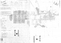
Mt. Pulaski Quadrangle
Mining in the Mt. Pulaski Quadrangle
Mining began in this quadrangle in 1883 in the area west of Mt. Pulaski when a mine was opened by Mr. B. F. Fox. This mine operated under various owners until it was finally closed in 1915. The El-Ben Mine, south of Lincoln, was the only other mine in the quadrangle and was active until closing in 1968. Both of these underground mines mined in the Springfield Coal seam (formerly known as the Number 5 Coal).
The Springfield Coal ranges in average thickness from 5.0 feet in the north to 4.0 feet in the Mt. Pulaski area, and from 270 to 365 feet in depth. Some water problems existed in this area, and clay dikes, or ‘horsebacks’, were common.
Map and Directory PDF Download
Coal Mines In Illinois Mt. Pulaski Quadrangle
Mines that Appear on the Mt. Pulaski Quadrangle
Unlocated Mines
Logan County
Pages in category "Mt. Pulaski Quadrangle"
The following 3 pages are in this category, out of 3 total.
Media in category "Mt. Pulaski Quadrangle"
The following 6 files are in this category, out of 6 total.
 M0278 coalreport1884 p504.pdf 783 × 1,220; 482 KB
 M0278 coalreport1885 p74 75.pdf 1,650 × 1,295; 934 KB
 M0278 minenotes.pdf 731 × 1,202, 6 pages; 1.5 MB
 M0278 quade.jpg 2,796 × 2,958; 1.52 MB
 M0639 352537 geo.jpg 2,978 × 2,090; 2.2 MB
 M0639 minenotes.pdf 731 × 1,202, 71 pages; 28.93 MB

