File:M0846.jpg

Size of this preview: 513 × 600 pixels. Other resolutions: 1,752 × 2,048 pixels | 2,900 × 3,390 pixels.
Original file (2,900 × 3,390 pixels, file size: 905 KB, MIME type: image/jpeg)
CLICK HERE TO DOWNLOAD THE HIGH RESOLUTION IMAGE. FILE SIZE MAY BE LARGE(Note:this file is usually better quality than "original file" linked above)
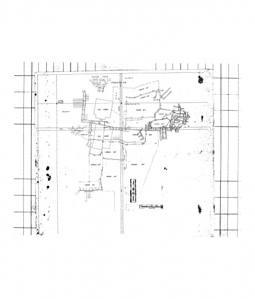
| Mine Index(s): | 0846 |
| Mine Company: | Lloyd Coal Company |
| Mine Name | Lloyd Mine |
| Map Date | 9-21-1959 |
| Map Scale | 1:1200 |
| Map Type microfilm/company/wpa/quade | Microfilm |
| Map Status final,not final, secondary | Not final |
| ID Number | 352224 |
| Used For | |
| Notes | microfilm, document 352224, reel 03138, frame 282 |
| Image Credit | |
| Hi-Res Download | Click to download |
The source map includes two public roads and "Stone NW Cor Sec 23". Above and to the east of a road is a label for "SE Sec 14". The N-S road is therefore positioned over the center line of the section. In order for the map to be scaled correctly, matching the scale bar and also the distance between the E-W section line and E-W road, the stone was assumed to be the NW corner NE NW.
File history
Click on a date/time to view the file as it appeared at that time.
| Date/Time | Thumbnail | Dimensions | User | Comment | |
|---|---|---|---|---|---|
| current | 10:56, May 31, 2019 | | 2,900 × 3,390 (905 KB) | Cheri (talk | contribs) |
You cannot overwrite this file.
File usage
The following page uses this file: