File:M0924.jpg

Size of this preview: 637 × 599 pixels. Other resolutions: 2,177 × 2,048 pixels | 3,390 × 3,189 pixels.
Original file (3,390 × 3,189 pixels, file size: 729 KB, MIME type: image/jpeg)
CLICK HERE TO DOWNLOAD THE HIGH RESOLUTION IMAGE. FILE SIZE MAY BE LARGE(Note:this file is usually better quality than "original file" linked above)
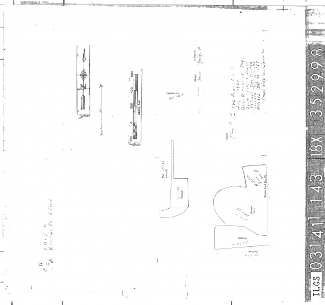
| Mine Index(s): | 0924 |
| Mine Company: | Two Rivers Coal Company |
| Mine Name | Two Rivers Mine |
| Map Date | 12-22-1955 |
| Map Scale | 1:2400 |
| Map Type microfilm/company/wpa/quade | Microfilm |
| Map Status final,not final, secondary | Final |
| ID Number | 352998 |
| Used For | Mine location, mine outline, mining method |
| Notes | Microfilm map, document 352998, reel 03141, frame 143. The map stated “Final” although the survey date would indicate it showed the extent of the mine only 3 years after opening. The source map was very faint and difficult to read. An original copy of the microfilm map was found at the Vermilion County Clerk’s office, and no later date was noted on the more legible copy. The mined area shown on the accompanying map is the approximate size expected for the production reported. This suggests that the mine outline is complete. |
| Image Credit | |
| Hi-Res Download | Click to download |
File history
Click on a date/time to view the file as it appeared at that time.
| Date/Time | Thumbnail | Dimensions | User | Comment | |
|---|---|---|---|---|---|
| current | 11:07, February 25, 2020 | | 3,390 × 3,189 (729 KB) | Cheri (talk | contribs) |
You cannot overwrite this file.
File usage
There are no pages that use this file.