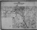
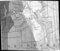
Danville SE Quadrangle
Mining in the Danville SE Quadrangle
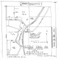
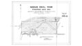
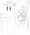
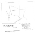
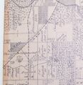
The Danville Coal and Herrin Coal were both mined in the Danville Southeast and Danville Southwest Quadrangles. This location is at the edge of the Illinois Basin and both coals are surface-minable near the Vermilion River.
The Danville Coal ranged from 4.75 to over 6 feet thick (thinner where eroded) and the Herrin Coal was generally 5 to 6 feet thick. The depth ranged from very little cover to over 200 feet for the Herrin Coal. The Danville Coal had some geologic problems for mining. Generally, it was closer to the surface, and sometimes water came into the mine. This was aggravated in some circumstances due to channel systems that were contemporaneous with deposition of the upper part of the coal and the roof shales. The channels sometimes cut down into the coal. Horsebacks and rolls were common.
Mining was an important part of the history of Danville since the coal was shallow. The first known mining took place in 1853 by Caruthers & Ball, south of Danville. Most of the early mines were quite small, the more extensive mines not beginning until around 1860. Michael Kelly began surface mining in 1868 along the North Fork but soon moved to Grape Creek and established several mines in that area. Surface mining operations were developed here, the Mission Field west of Danville (sections 19 and 20 of T19N-R12W) being the first site of machine mining with scrapers in 1866 (Kirkland, Blankey & Graves) and later on with the first dragline in 1890. Mining generally slowed significantly in the latter part of World War II, and for the last 30 years only one or two mines operated in Vermilion County.
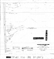
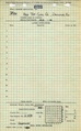
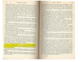
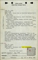
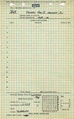
The back of this report includes mines that could not be located due to lack of source maps or locational information in the Coal Section mine notes. Most of these mines are underground and the production indicates approximately 1 square mile in addition to that shown on the map could be undermined.
Map and Directory PDF Download
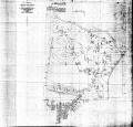
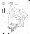
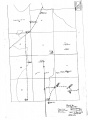
Coal Mines In Illinois Danville SE Quadrangle
Mines that Appear on the Danville SE Quadrangle
Unlocated Mines
Vermilion County
Pages in category "Danville SE Quadrangle"
The following 200 pages are in this category, out of 544 total.
(previous page) (next page)1
- 1830001
- 1830002
- 1830006
- 1830007
- 1830008
- 1830009
- 1830010
- 1830011
- 1830012
- 1830013
- 1830014
- 1830016a
- 1830016b
- 1830016c
- 1830017
- 1830018
- 1830019
- 1830022
- 1830023
- 1830025
- 1830026a
- 1830027b
- 1830029a
- 1830032
- 1830033
- 1830034
- 1830036
- 1830038
- 1830039a
- 1830039b
- 1830040
- 1830041a
- 1830042a
- 1830042b
- 1830042c
- 1830043a
- 1830043b
- 1830044
- 1830046
- 1830047a
- 1830048
- 1830049
- 1830052
- 1830053
- 1830054
- 1830055
- 1830056
- 1830061
- 1830062
- 1830063
- 1830066
- 1830069
- 1830070
- 1830071
- 1830072
- 1830074
- 1830077
- 1830079
- 1830080
- 1830081
- 1830082
- 1830083
- 1830084
- 1830085
- 1830086
- 1830088
- 1830090
- 1830091
- 1830094
- 1830095
- 1830096
- 1830098
- 1830103
- 1830104
- 1830105
- 1830106
- 1830107
- 1830108
- 1830109
- 1830110
- 1830112
- 1830113
- 1830114
- 1830115
- 1830116a
- 1830116b
- 1830116c
- 1830117
- 1830122
- 1830123
- 1830124
- 1830126
- 1830126a
- 1830128
- 1830129
- 1830130
- 1830131
- 1830134
- 1830135
- 1830136
- 1830137
- 1830138
- 1830141
- 1830147
- 1830148
- 1830151
- 1830152
- 1830153
- 1830154b
- 1830155
- 1830156
- 1830157
- 1830159
- 1830160
- 1830164a
- 1830165c
- 1830166a
- 1830166b
- 1830168
- 1830169
- 1830170
- 1830171
- 1830173
- 1830173a
- 1830173b
- 1830174
- 1830175
- 1830176a
- 1830176b
- 1830177
- 1830177a
- 1830178
- 1830179
- 1830180
- 1830181
- 1830182
- 1830183
- 1830184
- 1830185
- 1830188
- 1830190
- 1830191
- 1830192
- 1830193
- 1830195
- 1830196
- 1830197
- 1830198
- 1830199
- 1830200
- 1830201
- 1830203
- 1830204
- 1830205
- 1830206
- 1830207
- 1830207a
- 1830209
- 1830210
- 1830211
- 1830212
- 1830214
- 1830215
- 1830216a
- 1830216b
- 1830216c
- 1830217a
- 1830217b
- 1830218
- 1830219
- 1830220
- 1830221a
- 1830221b
- 1830222
- 1830223
- 1830224
- 1830226
- 1830228
- 1830231
- 1830233
- 1830234
- 1830236a
- 1830236b
- 1830237
- 1830238
- 1830239
- 1830240
- 1830241
- 1830243
- 1830244
- 1830245
- 1830246
- 1830247
- 1830249
- 1830250
- 1830251
- 1830252
Media in category "Danville SE Quadrangle"
The following 134 files are in this category, out of 134 total.
 Dantwp1895 Copy1.jpg 3,390 × 2,754; 1.52 MB
 Folio67d.jpg 1,511 × 1,273; 806 KB
 Folio67d2.jpg 1,511 × 1,273; 806 KB
 M-1007 Kelly No 5 Danville District Coop 17 Fig 42 6ft coal 200ft deep.jpg 2,500 × 1,484; 431 KB
 M-1008 Kelly No 5 Danville 6ft coal 200ft deep-ps.jpg 2,500 × 1,480; 545 KB
 M-1009 Kelly No 5 Danville District 6ft coal 200ft deep.jpg 2,500 × 1,461; 500 KB
 M-1010 Kelly No 5 Danville District 6ft coal 200ft deep.jpg 2,500 × 1,478; 573 KB
 M-1011 Kelly No 5 Danville District 6ft coal 200ft deep.jpg 1,454 × 2,500; 438 KB
 M-929 Subsidence Kelly No 5 Mine.jpg 4,408 × 2,666; 1.18 MB
 M0093 coalreport1912 p273.pdf 1,643 × 1,241, 2 pages; 692 KB
 M0093 minenotes.pdf 739 × 1,193, 34 pages; 8.03 MB
 M0093mrg.jpg 3,390 × 2,674; 3.14 MB
 M0656 minenotes.pdf 737 × 1,193, 5 pages; 1.42 MB
 M0656.jpg 3,346 × 3,390; 1,023 KB
 M0656b.jpg 3,390 × 1,934; 619 KB
 M0924 minenotes.pdf 739 × 1,193, 4 pages; 1.05 MB
 M0924.jpg 3,390 × 3,189; 729 KB
 M3650 minenotes.pdf 737 × 1,193, 4 pages; 1.11 MB
 M3650.jpg 2,714 × 3,390; 589 KB
 M3651 minenotes.pdf 737 × 1,193, 4 pages; 1.04 MB
 M3652 minenotes.pdf 737 × 1,193, 6 pages; 1.46 MB
 M3652.jpg 3,390 × 2,814; 968 KB
 M3653 minenotes.pdf 737 × 1,193, 8 pages; 2.19 MB
 M3653.jpg 2,853 × 3,390; 418 KB
 M3654 minenotes.pdf 737 × 1,193, 5 pages; 1.3 MB
 M3654.jpg 2,982 × 3,390; 732 KB
 M3655 minenotes.pdf 737 × 1,193, 11 pages; 2.82 MB
 M3655.jpg 2,884 × 3,390; 527 KB
 M3656 minenotes.pdf 737 × 1,193, 5 pages; 1.34 MB
 M3657 minenotes.pdf 737 × 1,193, 6 pages; 1.61 MB
 M3657.jpg 1,755 × 1,275; 512 KB
 M3659 minenotes.pdf 737 × 1,193, 5 pages; 1.37 MB
 M3659.jpg 2,598 × 3,390; 607 KB
 M3660 minenotes.pdf 737 × 1,193, 11 pages; 2.84 MB
 M3661 coalreport1896 p107.pdf 1,610 × 1,210; 300 KB
 M3661 minenotes.pdf 737 × 1,193, 4 pages; 1.11 MB
 M3661 msha1168.jpg 3,390 × 2,370; 1.13 MB
 M3664 coalreport1897 p79.pdf 839 × 1,185; 1.1 MB
 M3664 coalreport1898 p154.pdf 1,614 × 1,177; 321 KB
 M3664 minenotes.pdf 737 × 1,193, 8 pages; 2.09 MB
 M3664.jpg 3,390 × 2,154; 689 KB
 M3667 minenotes.pdf 737 × 1,193, 6 pages; 1.6 MB
 M3667.jpg 3,153 × 3,390; 770 KB
 M3675 minenotes.pdf 739 × 1,193, 4 pages; 1.06 MB
 M3681 minenotes.pdf 739 × 1,193, 6 pages; 1.63 MB
 M3681.jpg 2,890 × 3,390; 991 KB
 M3682 minenotes.pdf 739 × 1,193, 4 pages; 1.07 MB
 M3683 minenotes.pdf 739 × 1,193, 5 pages; 1.39 MB
 M3683.jpg 3,134 × 3,390; 736 KB
 M3684 minenotes.pdf 739 × 1,193, 4 pages; 1.1 MB
 M3685 minenotes.pdf 739 × 1,193, 6 pages; 1.6 MB
 M3685.jpg 3,390 × 2,945; 817 KB
 M3686 minenotes.pdf 739 × 1,193, 5 pages; 1.25 MB
 M3686a.jpg 3,390 × 2,812; 764 KB
 M3707 minenotes.pdf 739 × 1,193, 5 pages; 1.28 MB
 M3707.jpg 3,390 × 2,164; 1.07 MB
 M3708 minenotes.pdf 739 × 1,193, 2 pages; 574 KB
 M3710.jpg 3,390 × 3,252; 3.91 MB
 M3710b.jpg 3,390 × 3,252; 3.91 MB
 M3711 minenotes.pdf 739 × 1,193, 6 pages; 1.57 MB
 M3712 minenotes.pdf 739 × 1,193, 5 pages; 2.05 MB
 M3712.jpg 3,390 × 3,252; 3.91 MB
 M3713 352876.jpg 2,968 × 3,390; 1.05 MB
 M3713 minenotes.pdf 739 × 1,193, 2 pages; 563 KB
 M3714 minenotes.pdf 739 × 1,193, 5 pages; 1.27 MB
 M3715 minenotes.pdf 739 × 1,193, 4 pages; 1.08 MB
 M3716 minenotes.pdf 739 × 1,193, 4 pages; 1.06 MB
 M3717 minenotes.pdf 739 × 1,193, 4 pages; 1.06 MB
 M3718 minenotes.pdf 739 × 1,193, 2 pages; 535 KB
 M3718.jpg 2,718 × 3,390; 351 KB
 M3719 coalreport1884 p499.pdf 1,595 × 1,264, 2 pages; 734 KB
 M3719 coalreport1885 p70.pdf 1,652 × 1,293; 919 KB
 M3719 minenotes.pdf 739 × 1,193, 4 pages; 1.02 MB
 M3720 minenotes.pdf 737 × 1,193, 8 pages; 2.23 MB
 M3720.jpg 3,390 × 1,794; 644 KB
 M3722 minenotes.pdf 739 × 1,193, 4 pages; 1.06 MB
 M3723 minenotes.pdf 739 × 1,193, 2 pages; 593 KB
 M3724 minenotes.pdf 739 × 1,193, 4 pages; 1.11 MB
 M3725 minenotes.pdf 739 × 1,193, 4 pages; 1.13 MB
 M3726 minenotes.pdf 739 × 1,193, 5 pages; 1.41 MB
 M3726.jpg 3,390 × 2,891; 1.13 MB
 M3726b.jpg 2,316 × 3,390; 2.35 MB
 M3731 coalreport1884 p509.pdf 1,641 × 1,279; 363 KB
 M3731 coalreport1885 p70.pdf 1,652 × 1,293; 919 KB
 M3731 coalreport1898 p153.pdf 1,593 × 1,172; 182 KB
 M3731 minenotes.pdf 739 × 1,193, 4 pages; 1.12 MB
 M3733 coalreport1899 p80.pdf 1,481 × 1,216; 349 KB
 M3733 minenotes.pdf 739 × 1,193, 4 pages; 1.11 MB
 M3736 minenotes.pdf 739 × 1,193, 2 pages; 615 KB
 M3737 coalreport1897 p79.pdf 839 × 1,185; 1.1 MB
 M3737 minenotes.pdf 739 × 1,193, 6 pages; 1.64 MB
 M3739 minenotes.pdf 739 × 1,193, 6 pages; 1.59 MB
 M3740 minenotes.pdf 739 × 1,193, 4 pages; 1.11 MB
 M3740 msha1050.jpg 3,390 × 2,771; 1.8 MB
 M3742 minenotes.pdf 739 × 1,193, 6 pages; 1.67 MB
 M3743 minenotes.pdf 739 × 1,193, 4 pages; 1,017 KB
 M3744 minenotes.pdf 739 × 1,193, 3 pages; 836 KB
 M3745 minenotes.pdf 739 × 1,193, 5 pages; 1.25 MB
 M3746 minenotes.pdf 739 × 1,193, 5 pages; 1.37 MB
 M3747 minenotes.pdf 739 × 1,193, 4 pages; 1.09 MB
 M3747.jpg 3,390 × 3,076; 968 KB
 M3750 coalreport1885 p70.pdf 602 × 975; 96 KB
 M3750 minenotes.pdf 739 × 1,193, 11 pages; 2.97 MB
 M3751 minenotes.pdf 739 × 1,193, 4 pages; 1.07 MB
 M3752 minenotes.pdf 739 × 1,193, 4 pages; 1.06 MB
 M3753 minenotes.pdf 739 × 1,193, 4 pages; 1.13 MB
 M3753.jpg 2,690 × 3,390; 697 KB
 M3754 minenotes.pdf 739 × 1,193, 4 pages; 1.1 MB
 M3755 minenotes.pdf 739 × 1,193, 4 pages; 1.05 MB
 M3756 coalreport1885 p70.pdf 1,652 × 1,293; 918 KB
 M3756 minenotes.pdf 739 × 1,193, 4 pages; 1.05 MB
 M3757 minenotes.pdf 739 × 1,193, 5 pages; 1.36 MB
 M5735 fieldnotes.pdf 750 × 1,185; 189 KB
 M6310 minenotes.pdf 739 × 1,193, 4 pages; 1.08 MB
 M6516 minenotes.pdf 739 × 1,193, 3 pages; 743 KB
 M6516.jpg 3,390 × 3,178; 520 KB
 M6517 minenotes.pdf 739 × 1,193, 6 pages; 1.55 MB
 M6522 minenotes.pdf 739 × 1,193, 3 pages; 866 KB
 M6522.jpg 3,063 × 3,390; 644 KB
 M6543 minenotes.pdf 739 × 1,193, 3 pages; 765 KB
 M6544 minenotes.pdf 739 × 1,193, 2 pages; 556 KB
 M6566 minenotes.pdf 739 × 1,193, 2 pages; 542 KB
 M6567 minenotes.pdf 739 × 1,193, 3 pages; 832 KB
 M6567.jpg 2,596 × 3,390; 1.08 MB
 M6568 minenotes.pdf 739 × 1,193, 2 pages; 540 KB
 M6569 minenotes.pdf 739 × 1,193, 2 pages; 563 KB
 M6670 minenotes.pdf 739 × 1,193, 4 pages; 1.05 MB
 M6670.jpg 3,294 × 3,130; 789 KB
 M6756 minenotes.pdf 739 × 1,193, 4 pages; 1.08 MB
 M6771 minenotes.pdf 739 × 1,193, 3 pages; 810 KB
 M6774 fieldnotes.pdf 750 × 1,185; 190 KB
 M7111.jpg 610 × 627; 116 KB
 Vday.jpg 2,493 × 3,390; 552 KB
 Vday2.jpg 2,493 × 3,390; 552 KB


