3593: Difference between revisions
Alan.Myers (talk | contribs) No edit summary |
No edit summary |
||
| Line 10: | Line 10: | ||
|county1=St. Clair | |county1=St. Clair | ||
|quad1=Lebanon | |quad1=Lebanon | ||
|year-start= | |datemod=pre | ||
|year-start=1874 | |||
|year-end=1890 | |year-end=1890 | ||
|Latitude=38.5932297140001 | |Latitude=38.5932297140001 | ||
| Line 102: | Line 103: | ||
}} | }} | ||
{{Annotated bibliography | {{Annotated bibliography | ||
|bibliography= | |bibliography=Mine notes (St. Clair County) - Shaft locations, seam, depth, thickness. | ||
}} | }} | ||
{{Annotated bibliography | {{Annotated bibliography | ||
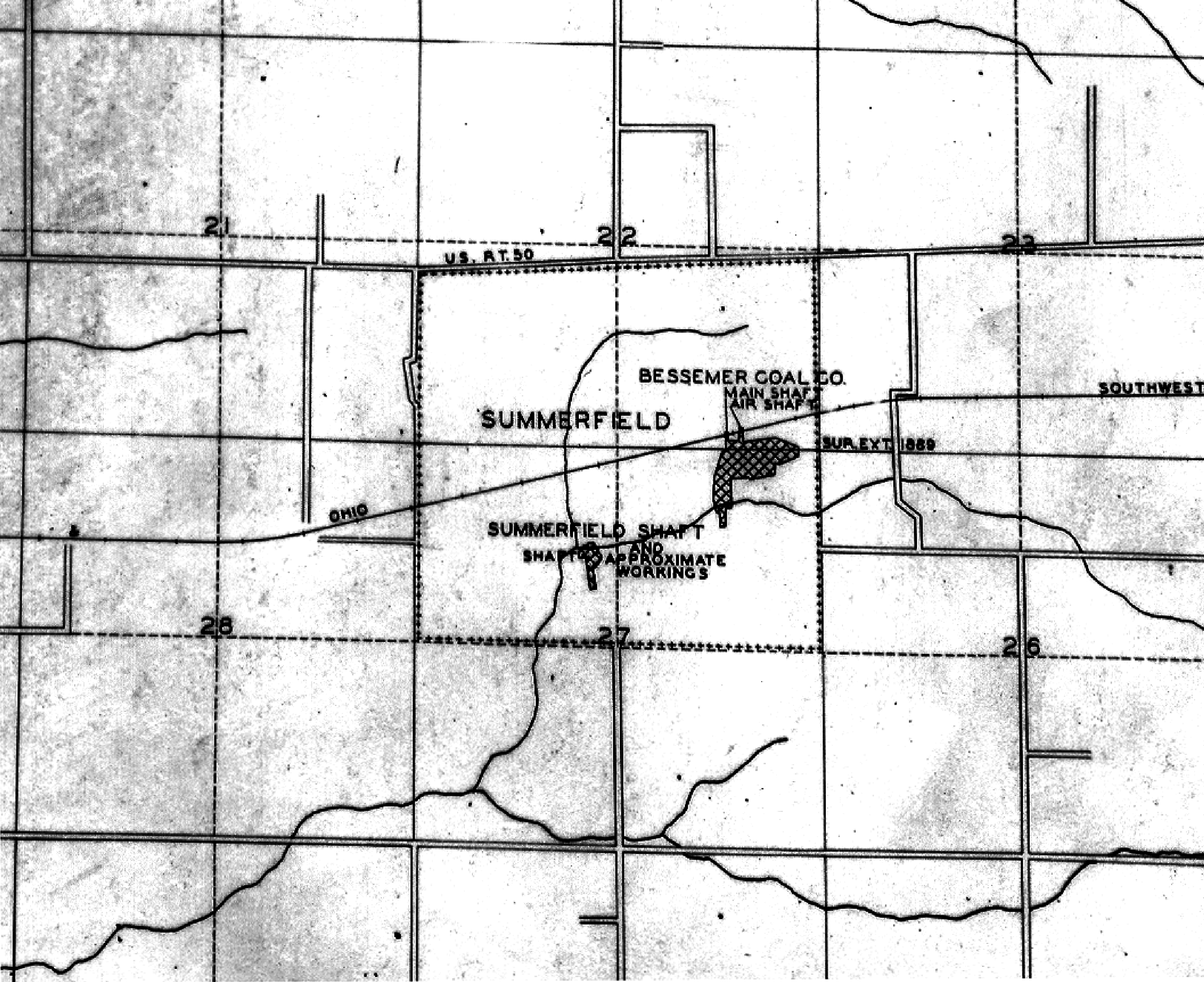
|bibliography=WPA map, T2N-R6W - Shaft locations, approximate workings. | |bibliography=WPA map, T2N-R6W - Shaft locations, approximate workings. | ||
}} | }} | ||
{{Annotated bibliography | {{Annotated bibliography | ||
| Line 119: | Line 117: | ||
{{Query-image}} | {{Query-image}} | ||
===Photographs=== | |||
{{Photo Query}} | |||
==Additional Notes== | |||
{{Editwithform}} | |||
{{Editwithform}} | {{Editwithform}} | ||
Revision as of 14:52, August 5, 2021
Mine Index Number: 3593
| Company Name: | McKinley Coal Company | ||
|---|---|---|---|
| Mine Name: | Summerfield Mine | ||
| Start Date: | pre 1874 | End Date: | 1890 |
| Type of Mine: | Underground | ||
| Total acres shown: | 2 The source map for this mine is a secondary source map, and indicates that the workings are only approximate. Production indicates about 15 acres were mined. | ||
| Acres after map date: | General Area of mining acres shown: | ||
Shaft, Slope, Drift or Tipple Location(s)
| Type | County | Township-Range | Section | Part Section |
|---|
| Main shaft | St. Clair | 2N 6W | 27 | NE SE NW |
| Escapement The Coal Report of 1888 indicated a 300-foot deep escapement shaft had been completed. The location of this shaft is not known. | St. Clair | 2N 6W | 27 |
Geology
| Thickness (ft) | |||||
|---|---|---|---|---|---|
| Seam | Depth (ft) | Min | Max | Ave | Mining Method |
| Herrin | 180-285 | 4.0-5.0 | RPB |
Geological Problems Reported
Production
| Company | Mine Name | Date | Production (tons) |
| John Wingler | Summerfield | pre1874-1883 | 12,380 Production and ownership prior to 1883 unknown. The Coal Report of 1883 indicates 15 acres mined. |
| Fisher and Harrison | Summerfield | 1883-1884 | 1,700 The inspector noted in the Coal Report of 1884 that this mine had changed hands three times. These owners are unknown. The production reported may not include all the tonnage mined under these unknown operators. |
| Summerfield Coal Company | Summerfield | 1884-1887 Idle 1886 | 6,280 |
| Bessemer Coal Company | Summerfield | 1887-1889 | 29,651 |
| McKinley Coal Company | Summerfield | 1889-1890 | 10,520 |
Production Notes
Coal Report production (if available)
Sources of Data
| Source Map | Map Date | Original Scale | Digitized Scale | Map Type |
| WPA, T2N-R6W | 1935 | 1:12000 | 1:54340 | Secondary source |
Annotated Bibliography (Data source - brief description of information)
| Coal Reports - Production, ownership, years of operation, thickness. |
| Directory of Illinois Coal Mines (St. Clair County) - Mine names, mine index, ownership, years of operation. |
| Mine notes (St. Clair County) - Shaft locations, seam, depth, thickness. |
| WPA map, T2N-R6W - Shaft locations, approximate workings. |
| 1874 Atlas of St. Clair County - Years of operation. |
Mine Notes
Mine Images

Photographs
Additional Notes