0205: Difference between revisions
Alan.Myers (talk | contribs) No edit summary |
Alan.Myers (talk | contribs) No edit summary |
||
| Line 1: | Line 1: | ||
{{Sidebar Info Query}} | {{Sidebar Info Query}} | ||
{{Header | {{Header | ||
|checked=Checked OK | |||
|unlocated=No | |unlocated=No | ||
|shown_on_map=Yes | |shown_on_map=Yes | ||
| Line 15: | Line 16: | ||
|Latitude=38.223478797 | |Latitude=38.223478797 | ||
|Longitude=-89.712493137 | |Longitude=-89.712493137 | ||
|Zoom=15 | |||
}} | }} | ||
==Shaft, Slope, Drift or Tipple Location(s)== | ==Shaft, Slope, Drift or Tipple Location(s)== | ||
Revision as of 09:20, December 7, 2021
Mine Index Number: 0205
| Company Name: | Egyptian Coal and Mining Company | ||
|---|---|---|---|
| Mine Name: | Meek No. 2 Mine | ||
| Start Date: | 1904 | End Date: | 1928 |
| Type of Mine: | Underground | ||
| Total acres shown: | 110 | ||
| Acres after map date: | 115 | General Area of mining acres shown: | |
Shaft, Slope, Drift or Tipple Location(s)
| Type | County | Township-Range | Section | Part Section |
|---|
| Main shaft | St. Clair | 3S 6W | 36 | SE NE SW |
| Air shaft The mine is connected underground to White Oak Mine (mine index 3625), which made another place of egress for escapement. | St. Clair | 3S 6W | 36 | SE NE SW |
Geology
| Thickness (ft) | |||||
|---|---|---|---|---|---|
| Seam | Depth (ft) | Min | Max | Ave | Mining Method |
| Herrin | 183-210 | 5.0 | 7.0 | 6.5 | MRP |
Geological Problems Reported
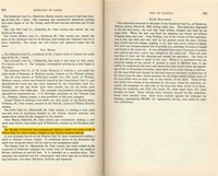
The roof was a type of shale referred to as “slate”. The roof was good and only came down with the coal in widely scattered parts of the mine. The shale ranged from 0.5 inches to 3 feet thick. Up to 12 feet of limestone was above the shale. Minor slips occurred in the shale, and these areas of slip made an unstable roof. Streaks and lenses of pyrite were present through the coal bed. The blue band consisted of 0.75 to 1 inch of shale that was about 16 inches above the floor. The blue band adhered to the coal, and generally 1 inch of coal above and below the blue band was left in the mine
Production
| Company | Mine Name | Date | Production (tons) |
| T. M. Meeks | Meeks | 1904-1912 | 150,573 Idle 1909 |
| Egyptian Coal and Mining Company | Meeks No. 2The mine was listed in the Coal Reports as No. 2 in 1913 & 1914, and No. 1 from 1923 to 1925. No designation was noted in the other years. | 1912-1920 Idle 1915 | 481,181 |
| Egyptian Coal and Mining Company | Meeks No. 2 | 1920-1928 | 671,426 Production after map date |
Production Notes
Coal Report production (if available)
Sources of Data
| Source Map | Map Date | Original Scale | Digitized Scale | Map Type |
| Microfilm, document 351249 | 8-27-1920 | 1:2400 | 1:4634 | Not final |
Annotated Bibliography (Data source - brief description of information)
| Coal Reports - Production, ownership, years of operation. |
| Directory of Illinois Coal Mines (St. Clair County) - Mine names, mine index, ownership, years of operation. |
| Mine notes (St. Clair County) - Mine type, shaft location, seam, depth, thickness, geologic problems. |
| Microfilm map, document 351249, reel 03134, frames 259 & 260 - Shaft locations, mine outline, mining method. |
Mine Notes
Mine Images
![[[:Meeks No. 2|Meeks No. 2]]](https://wikiimage.isgs.illinois.edu/ilmines/st_clair/thumbnails/m0205_IL_122_01_th.jpg)
Photographs