0060: Difference between revisions
Alan.Myers (talk | contribs) No edit summary |
No edit summary |
||
| (4 intermediate revisions by 2 users not shown) | |||
| Line 1: | Line 1: | ||
{{Sidebar Info Query}} | {{Sidebar Info Query}} | ||
{{Header | {{Header | ||
|checked=Checked OK | |||
|unlocated=No | |unlocated=No | ||
|shown_on_map=Yes | |shown_on_map=Yes | ||
| Line 7: | Line 8: | ||
|Mine Name Header=Peabody No. 3 Mine | |Mine Name Header=Peabody No. 3 Mine | ||
|mine_type=Underground | |mine_type=Underground | ||
|mined-out-area=2,019 {{#info: | |mined-out-area=2,019 {{#info:connected underground to Peabody No. 1 (mine index 4026) and Peabody No. 2 (mine index 4028). Boundaries between the mines could not be differentiated.|note}} | ||
|gam=22 | |||
|county1=Williamson | |county1=Williamson | ||
|quad1=Johnston City | |quad1=Johnston City | ||
|city1=Marion | |||
|year-start=1900 | |year-start=1900 | ||
|year-end=1929 | |year-end=March 1929 | ||
|Latitude=37.7677695368217 | |Latitude=37.7677695368217 | ||
|Longitude=-88.9459013369489 | |Longitude=-88.9459013369489 | ||
| Line 49: | Line 52: | ||
{{Production header}} | {{Production header}} | ||
{{Production | {{Production | ||
|Company=Southern Illinois Coal | |Company=Southern Illinois Coal Mining and Washing Company | ||
|Mine-Name=Southern Illinois No. 3 | |Mine-Name=Southern Illinois No. 3 | ||
|Date=1900-1904 | |Date=1900-1904 | ||
|Production=488,673 | |Production=488,673 | ||
|Sum=No | |||
}} | }} | ||
{{Production | {{Production | ||
| Line 59: | Line 63: | ||
|Date=1904-1929 | |Date=1904-1929 | ||
|Production=10,547,879 | |Production=10,547,879 | ||
|Sum=No | |||
| | |||
}} | }} | ||
{{Production | {{Production | ||
|Production=11,036,552 | |Production=11,036,552 | ||
|Sum=Yes | |||
}} | }} | ||
===Production Notes=== | ===Production Notes=== | ||
| Line 98: | Line 101: | ||
{{Query-image}} | {{Query-image}} | ||
===Photographs=== | |||
{{Photo Query}} | |||
{{Editwithform}} | |||
{{Editwithform}} | {{Editwithform}} | ||
Latest revision as of 12:26, April 19, 2022
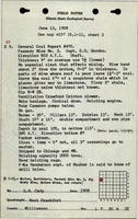
Mine Index Number: 0060
| Company Name: | Peabody Coal Company | ||
|---|---|---|---|
| Mine Name: | Peabody No. 3 Mine | ||
| Start Date: | 1900 | End Date: | March 1929 |
| Type of Mine: | Underground | ||
| Total acres shown: | 2,019 connected underground to Peabody No. 1 (mine index 4026) and Peabody No. 2 (mine index 4028). Boundaries between the mines could not be differentiated. | ||
| Acres after map date: | General Area of mining acres shown: | 22 | |
Shaft, Slope, Drift or Tipple Location(s)
| Type | County | Township-Range | Section | Part Section |
|---|
| Main shaft (10 x 17.75 ft) | Williamson | 9S 2E | 1 | SW SW NW |
| Air shaft | Williamson | 9S 2E | 1 | NW NW SW |
Geology
| Thickness (ft) | |||||
|---|---|---|---|---|---|
| Seam | Depth (ft) | Min | Max | Ave | Mining Method |
| Herrin | 116 | 11.0 | 7.0-9.0 | MRP |
Geological Problems Reported
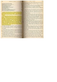
The roof was generally gray shale, requiring 1.5 to 2 feet of top coal for support. In some areas, the roof was black shale and/or limestone. The source map showed caved areas in the southeast tip of the mine. Many small unmined areas within the mine showed that geologic problems of some kind hindered mining, but these were not labeled on the source map.
Production
| Company | Mine Name | Date | Production (tons) |
| Southern Illinois Coal Mining and Washing Company | Southern Illinois No. 3 | 1900-1904 | 488,673 |
| Peabody Coal Company | Peabody No. 3 | 1904-1929 | 10,547,879 |
| Total Production: 11,036,552 | |||
Production Notes
Coal Report production (if available)
Sources of Data
| Source Map | Map Date | Original Scale | Digitized Scale | Map Type |
| Company, 4103.W52 i5.1-143 | 8-4-1932 | 1:2400 | 1:2400 | Final |
Annotated Bibliography (Data source - brief description of information)
| Coal Reports - Production, ownership, years of operation, thickness. |
| Directory of Illinois Coal Mines (Williamson County) - Mine names, mine index, ownership, years of operation. |
| Mine notes (Williamson County) - Mine type, shaft locations, seam, depth, thickness, geologic problems. |
| Company map, ISGS map library, 4103.W52 i5.1-143 - Shaft locations, mine outline, mining method, geologic problems. |
Mine Notes
Mine Images
![[[:Peabody No. 3|Peabody No. 3]]](https://wikiimage.isgs.illinois.edu/ilmines/williamson/thumbnails/m0060_th.jpg)
Photographs