0157: Difference between revisions
No edit summary |
No edit summary |
||
| Line 60: | Line 60: | ||
|Date=1901-1906 | |Date=1901-1906 | ||
|Production=545,221 | |Production=545,221 | ||
|Sum=No | |||
}} | }} | ||
{{Production | {{Production | ||
| Line 66: | Line 67: | ||
|Date=1906-1909 {{#info: Idle 1909|note}} | |Date=1906-1909 {{#info: Idle 1909|note}} | ||
|Production=148,442 | |Production=148,442 | ||
|Sum=No | |||
}} | }} | ||
{{Production | {{Production | ||
| Line 72: | Line 74: | ||
|Date=1909-1920 | |Date=1909-1920 | ||
|Production=2,192,177 | |Production=2,192,177 | ||
|Sum=No | |||
}} | }} | ||
{{Production | {{Production | ||
| Line 78: | Line 81: | ||
|Date=1920-1927 | |Date=1920-1927 | ||
|Production=2,916,108 | |Production=2,916,108 | ||
|Sum=No | |||
}} | }} | ||
{{Production | {{Production | ||
| Line 84: | Line 88: | ||
|Date=1928-1929 | |Date=1928-1929 | ||
|Production=269,354 | |Production=269,354 | ||
|Sum=No | |||
}} | }} | ||
{{Production | {{Production | ||
| Line 90: | Line 95: | ||
|Date=1929-1929 {{#info: Reported idle 1930-1933, but never reopened|note}} | |Date=1929-1929 {{#info: Reported idle 1930-1933, but never reopened|note}} | ||
|Production=181,629 {{#info: Production after map date|note}} | |Production=181,629 {{#info: Production after map date|note}} | ||
|Sum=No | |||
| | |||
}} | }} | ||
{{Production | {{Production | ||
|Production=6,252,931 | |Production=6,252,931 | ||
|Sum=Yes | |||
}} | }} | ||
===Production Notes=== | ===Production Notes=== | ||
Revision as of 12:36, April 19, 2022
Mine Index Number: 0157
| Company Name: | Peabody Coal Company | ||
|---|---|---|---|
| Mine Name: | Peabody No. 26 Mine | ||
| Start Date: | 1901 | End Date: | December 1929 |
| Type of Mine: | Underground | ||
| Total acres shown: | 925 This mine is connected underground in numerous places to the workings of the Oak Ridge Mine (mine index 322), in the northwest part of Peabody No. 26 Mine. | ||
| Acres after map date: | 27 | General Area of mining acres shown: | |
Shaft, Slope, Drift or Tipple Location(s)
| Type | County | Township-Range | Section | Part Section |
|---|
| Main shaft (9 x 13 ft) | Williamson | 8S 2E | 25 | NW NE SE |
| Air shaft | Williamson | 8S 2E | 25 | NW NE SE |
Geology
| Thickness (ft) | |||||
|---|---|---|---|---|---|
| Seam | Depth (ft) | Min | Max | Ave | Mining Method |
| Herrin | 125 | 6.0 | 9.0 | 8.0 | MRP |
Geological Problems Reported
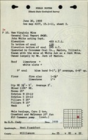
The northern part of the mine had northwest-trending faults of the Cottage Grove Fault System and north-northwest-trending high-angle normal faults of the White Ash Fault Zone in the western part of the mine. The roof was a massive gray shale over the entire mine, ranging from 2 inches to over 10 feet. In the eastern part of the mine, it ranged from 2 to 36 inches and came down readily. Where possible, 1 to 2 feet of coal were left to support the roof. The upper surface of the coal was very irregular. There were many slips in the roof, which allowed much water to come into the mine. Some slips and rolls were present in the coal. Slips also necessitated timbering. One roll came down into the coal 2 feet and was 50 feet long. The coal remained full thickness. Pyrite lenses and stringers, and calcite and gypsum fracture fillings were present in the coal. The floor was 2 inches to 4 feet of hard brittle dark gray shale. Where this clay shale was thick and the rooms were cut too wide, the floor tended to heave if it became wet, or else the roof came down.
Production
| Company | Mine Name | Date | Production (tons) |
| New Virginia Coal Company | New Virginia No. 1 | 1901-1906 | 545,221 |
| Consumers Coal Company | Consumers No. 1 | 1906-1909 Idle 1909 | 148,442 |
| Big Muddy Fuel Company | New Virginia No. 26 | 1909-1920 | 2,192,177 |
| Big Muddy Coal Company | Big Muddy No. 26 | 1920-1927 | 2,916,108 |
| Peabody Coal Company | Peabody No. 26 | 1928-1929 | 269,354 |
| Peabody Coal Company | Peabody No. 26 | 1929-1929 Reported idle 1930-1933, but never reopened | 181,629 Production after map date |
| Total Production: 6,252,931 | |||
Production Notes
Coal Report production (if available)
Sources of Data
| Source Map | Map Date | Original Scale | Digitized Scale | Map Type |
| Company, 4103.W52 i5.1-137 | 3-23-1929 | 1:2400 | 1:2400 | Not final |
Annotated Bibliography (Data source - brief description of information)
| Coal Reports - Production, ownership, years of operation, shaft size (1901). |
| Directory of Illinois Coal Mines (Williamson County) - Mine names, mine index, ownership, years of operation. |
| Mine notes (Williamson County) - Mine type, shaft and air shaft locations, seam, depth, thickness, geologic problems. |
| Company map, ISGS map library, 4103.W52 i5.1-137 - Shaft location, mine outline, mining method. |
| Catalog of Coal Mines in Williamson County, W. John Nelson, 2003 - Geologic problems. |
Mine Notes


Mine Images

Photographs