3983: Difference between revisions
No edit summary |
No edit summary |
||
| Line 1: | Line 1: | ||
{{Sidebar Info Query}} | {{Sidebar Info Query}} | ||
{{Header | {{Header | ||
|checked=Checked | |checked=Checked Problem | ||
|unlocated=No | |unlocated=No | ||
|shown_on_map=Yes | |shown_on_map=Yes | ||
Revision as of 14:14, August 4, 2022
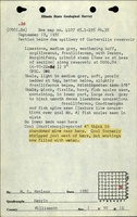
Mine Index Number: 3983
| Company Name: | Unknown | ||
|---|---|---|---|
| Mine Name: | |||
| Start Date: | Unknown | End Date: | Unknown |
| Type of Mine: | Surface | ||
| Total acres shown: | |||
| Acres after map date: | General Area of mining acres shown: | ||
Shaft, Slope, Drift or Tipple Location(s)
| Type | County | Township-Range | Section | Part Section |
|---|
| Pit | Williamson | 9S 1E | 1 | S ½ |
Geology
| Thickness (ft) | |||||
|---|---|---|---|---|---|
| Seam | Depth (ft) | Min | Max | Ave | Mining Method |
| Springfield | Surface |
Geological Problems Reported
Production
| Company | Mine Name | Date | Production (tons) |
Production Notes
Coal Report production (if available)
Sources of Data
| Source Map | Map Date | Original Scale | Digitized Scale | Map Type |
| ISGS field notes (Wanless) | 1931 | (text only) | 1:24000 The mine location was plotted on a 1:24000 USGS topographic map from the mine location description and digitized. | Secondary source |
Annotated Bibliography (Data source - brief description of information)
| ISGS field notes (Williamson County) - Mine type, mine location. |
Mine Notes
Mine Images
Photographs