0994: Difference between revisions
Alan.Myers (talk | contribs) No edit summary |
No edit summary |
||
| (4 intermediate revisions by 2 users not shown) | |||
| Line 1: | Line 1: | ||
{{Sidebar Info Query}} | {{Sidebar Info Query}} | ||
{{Header | {{Header | ||
|checked=Checked OK | |||
|unlocated=No | |unlocated=No | ||
|shown_on_map=Yes | |shown_on_map=Yes | ||
| Line 9: | Line 10: | ||
|mined-out-area=16 | |mined-out-area=16 | ||
|after_map=32 | |after_map=32 | ||
|indicated=No | |||
|county1=Vermilion | |county1=Vermilion | ||
|quad1=Danville | |quad1=Danville SW | ||
|year-start=1979 | |year-start=1979 | ||
|year-end=1981 | |year-end=October 1981 | ||
|Latitude=40.1159375 | |Latitude=40.1159375 | ||
|Longitude=-87.681711814 | |Longitude=-87.681711814 | ||
| Line 21: | Line 23: | ||
{{Shaft locations header}} | {{Shaft locations header}} | ||
{{Shaft locations | {{Shaft locations | ||
|shaft_type=Main drift | |shaft_type=Main drift (haulage) | ||
|County=Vermilion | |County=Vermilion | ||
|Town-Range=19N 12W | |Town-Range=19N 12W | ||
| Line 28: | Line 30: | ||
}} | }} | ||
{{Shaft locations | {{Shaft locations | ||
|shaft_type= | |shaft_type=Drift (belt haulage) | ||
|County=Vermilion | |County=Vermilion | ||
|Town-Range=19N 12W | |Town-Range=19N 12W | ||
| Line 35: | Line 37: | ||
}} | }} | ||
{{Shaft locations | {{Shaft locations | ||
|shaft_type=Air | |shaft_type=Air drift (return) | ||
|County=Vermilion | |County=Vermilion | ||
|Town-Range=19N 12W | |Town-Range=19N 12W | ||
| Line 42: | Line 44: | ||
}} | }} | ||
{{Shaft locations | {{Shaft locations | ||
|shaft_type=Air | |shaft_type=Air drift (intake) | ||
|County=Vermilion | |County=Vermilion | ||
|Town-Range=19N 12W | |Town-Range=19N 12W | ||
| Line 60: | Line 62: | ||
}} | }} | ||
===Geological Problems Reported=== | ===Geological Problems Reported=== | ||
“The old works above this underground mine are full of water, presenting a worry since only about 20 feet of strata separate the No. 6 and No. 7 Coals.” Three roof falls of 7 to 10 feet of shale above the coal were noted. In places the topmost layers of coal were fractured and mixed with shale or clay in what could be called a “white top” disturbance. Elsewhere the contact of coal to shale gave the appearance of being an erosional surface. Clay dikes were present between the layers of black shale roof. | “The old works above this underground mine are full of water, presenting a worry since only about 20 feet of strata separate the No. 6 and No. 7 Coals.” Three roof falls of 7 to 10 feet of shale above the coal were noted. In places the topmost layers of coal were fractured and mixed with shale or clay in what could be called a “white top” disturbance. Elsewhere the contact of coal to shale gave the appearance of being an erosional surface. Clay dikes were present between the layers of black shale roof. Concretions were present in the mid-to-upper part of the seam in some places. A major problem in this mine was the variability in thickness as well as quality. The coal was generally 7 to 8 feet thick, but pinched down to as little as 2 feet. Thin coal was due to rolls in some instances, erosion of the upper portion of the coal in some instances, and in other cases the thin coal was depositional, topographic highs where less peat accumulated. This caused the mine output to be high in ash content as the continuous miner took in portions of the roof and floor where the coal thinned. “Sulfur is said to vary from 2.2% to 4.1% and Btus from 11,200 to 11,800 within the small area already mined.” | ||
==Production== | ==Production== | ||
| Line 70: | Line 72: | ||
|Date=1979-1980 | |Date=1979-1980 | ||
|Production=99,025 | |Production=99,025 | ||
|Sum=No | |||
}} | }} | ||
{{Production | {{Production | ||
| Line 76: | Line 79: | ||
|Date=1980-1980 | |Date=1980-1980 | ||
|Production=43,765 {{#info: Production after map date|note}} | |Production=43,765 {{#info: Production after map date|note}} | ||
|Sum=No | |||
}} | }} | ||
{{Production | {{Production | ||
| Line 82: | Line 86: | ||
|Date=1981-1981 | |Date=1981-1981 | ||
|Production=126,668 {{#info: Production after map date|note}} | |Production=126,668 {{#info: Production after map date|note}} | ||
|Sum=No | |||
| | |||
}} | }} | ||
{{Production | {{Production | ||
|Production=269,458 | |Production=269,458 | ||
|Sum=Yes | |||
}} | }} | ||
===Production Notes=== | ===Production Notes=== | ||
| Line 96: | Line 99: | ||
{{Source map header}} | {{Source map header}} | ||
{{Source Map | {{Source Map | ||
|Source Map=Company map | |Source Map=Company map, 10-6-8 | ||
|Map Date=3-13-1980 | |Map Date=3-13-1980 | ||
|Original Scale=1:1200 | |Original Scale=1:1200 | ||
| Line 103: | Line 106: | ||
}} | }} | ||
{{Source Map | {{Source Map | ||
|Source Map=Company map | |Source Map=Company map, 10-3-17 | ||
|Map Date=4-15-1980 | |Map Date=4-15-1980 | ||
|Original Scale=1:1200 | |Original Scale=1:1200 | ||
| Line 115: | Line 118: | ||
{{Annotated bibliography | {{Annotated bibliography | ||
|bibliography=Directory of Illinois Coal Mines (Vermilion County) - Mine names, mine index, ownership, years of operation. | |bibliography=Directory of Illinois Coal Mines (Vermilion County) - Mine names, mine index, ownership, years of operation. | ||
}} | }} | ||
{{Annotated bibliography | {{Annotated bibliography | ||
| Line 123: | Line 123: | ||
}} | }} | ||
{{Annotated bibliography | {{Annotated bibliography | ||
|bibliography=Company maps, Coal Section files - Drift | |bibliography=Company maps, Coal Section files, 10-6-8 and 10-3-17 - Drift locations, mine outline, mining method. | ||
}} | }} | ||
==Mine Notes== | ==Mine Notes== | ||
Latest revision as of 13:11, September 11, 2022
Mine Index Number: 0994
| Company Name: | Lee Coal Company | ||
|---|---|---|---|
| Mine Name: | Calefy Mine | ||
| Start Date: | 1979 | End Date: | October 1981 |
| Type of Mine: | Underground | ||
| Total acres shown: | 16 | ||
| Acres after map date: | 32 | General Area of mining acres shown: | |
Shaft, Slope, Drift or Tipple Location(s)
| Type | County | Township-Range | Section | Part Section |
|---|
| Main drift (haulage) | Vermilion | 19N 12W | 14 | NW NE NE |
| Drift (belt haulage) | Vermilion | 19N 12W | 14 | NW NE NE |
| Air drift (return) | Vermilion | 19N 12W | 14 | NW NE NE |
| Air drift (intake) | Vermilion | 19N 12W | 14 | NW NE NE |
Geology
| Thickness (ft) | |||||
|---|---|---|---|---|---|
| Seam | Depth (ft) | Min | Max | Ave | Mining Method |
| Herrin | 25–160 | 2.0 | 10.0 | 6.0 | CRP |
Geological Problems Reported
“The old works above this underground mine are full of water, presenting a worry since only about 20 feet of strata separate the No. 6 and No. 7 Coals.” Three roof falls of 7 to 10 feet of shale above the coal were noted. In places the topmost layers of coal were fractured and mixed with shale or clay in what could be called a “white top” disturbance. Elsewhere the contact of coal to shale gave the appearance of being an erosional surface. Clay dikes were present between the layers of black shale roof. Concretions were present in the mid-to-upper part of the seam in some places. A major problem in this mine was the variability in thickness as well as quality. The coal was generally 7 to 8 feet thick, but pinched down to as little as 2 feet. Thin coal was due to rolls in some instances, erosion of the upper portion of the coal in some instances, and in other cases the thin coal was depositional, topographic highs where less peat accumulated. This caused the mine output to be high in ash content as the continuous miner took in portions of the roof and floor where the coal thinned. “Sulfur is said to vary from 2.2% to 4.1% and Btus from 11,200 to 11,800 within the small area already mined.”
Production
| Company | Mine Name | Date | Production (tons) |
| Coal Producers, Inc. | Calefy | 1979-1980 | 99,025 |
| Coal Producers, Inc. | Calefy | 1980-1980 | 43,765 Production after map date |
| Lee Coal Company | Calefy | 1981-1981 | 126,668 Production after map date |
| Total Production: 269,458 | |||
Production Notes
Coal Report production (if available)
Sources of Data
| Source Map | Map Date | Original Scale | Digitized Scale | Map Type |
| Company map, 10-6-8 | 3-13-1980 | 1:1200 | 1:1200 | Not final |
| Company map, 10-3-17 | 4-15-1980 | 1:1200 | 1:1200 | Not final |
Annotated Bibliography (Data source - brief description of information)
| Coal Reports - Production, ownership, years of operation, depth, mining method. |
| Directory of Illinois Coal Mines (Vermilion County) - Mine names, mine index, ownership, years of operation. |
| Mine notes (Vermilion County) - Mine type, drift location, seam, depth, thickness, geologic problems. |
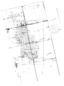
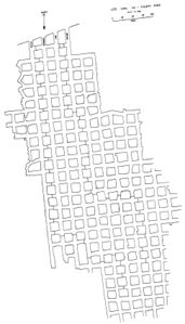
| Company maps, Coal Section files, 10-6-8 and 10-3-17 - Drift locations, mine outline, mining method. |
Mine Notes
Mine Images
Photographs


