2751: Difference between revisions
Alan.Myers (talk | contribs) No edit summary |
No edit summary |
||
| (4 intermediate revisions by 2 users not shown) | |||
| Line 1: | Line 1: | ||
{{Sidebar Info Query}} | {{Sidebar Info Query}} | ||
{{Header | {{Header | ||
|checked=Checked OK | |||
|unlocated=No | |unlocated=No | ||
|shown_on_map=Yes | |shown_on_map=Yes | ||
| Line 8: | Line 9: | ||
|mine_type=Underground | |mine_type=Underground | ||
|mined-out-area=195 | |mined-out-area=195 | ||
|indicated=No | |||
|county1=Madison | |county1=Madison | ||
|quad1=Collinsville | |quad1=Collinsville | ||
|datemod= | |datemod=Pre | ||
|year-start=1881 | |year-start=1881 | ||
|year-end=November 1912 | |year-end=November 1912 | ||
|Latitude=38.718104533 | |Latitude=38.718104533 | ||
|Longitude=-89.8849027209999 | |Longitude=-89.8849027209999 | ||
|Zoom= | |Zoom=13 | ||
}} | }} | ||
==Shaft, Slope, Drift or Tipple Location(s)== | ==Shaft, Slope, Drift or Tipple Location(s)== | ||
| Line 53: | Line 55: | ||
|Date=pre1881-1887 | |Date=pre1881-1887 | ||
|Production=276,312 | |Production=276,312 | ||
|Sum=No | |||
}} | }} | ||
{{Production | {{Production | ||
| Line 59: | Line 62: | ||
|Date=1887-1896 | |Date=1887-1896 | ||
|Production=315,510 | |Production=315,510 | ||
|Sum=No | |||
}} | }} | ||
{{Production | {{Production | ||
| Line 65: | Line 69: | ||
|Date=1896-1897 | |Date=1896-1897 | ||
|Production=38,220 | |Production=38,220 | ||
|Sum=No | |||
}} | }} | ||
{{Production | {{Production | ||
| Line 71: | Line 76: | ||
|Date=1897-1906 | |Date=1897-1906 | ||
|Production=319,414 | |Production=319,414 | ||
|Sum=No | |||
}} | }} | ||
{{Production | {{Production | ||
| Line 77: | Line 83: | ||
|Date=1906-1912 | |Date=1906-1912 | ||
|Production=166,019 | |Production=166,019 | ||
|Sum=No | |||
| | |||
}} | }} | ||
{{Production | {{Production | ||
|Production=1,115,475 | |Production=1,115,475 | ||
|Sum=Yes | |||
}} | }} | ||
===Production Notes=== | ===Production Notes=== | ||
Latest revision as of 14:50, October 10, 2022
Mine Index Number: 2751
| Company Name: | Brookside Coal Company | ||
|---|---|---|---|
| Mine Name: | Brookside Mine | ||
| Start Date: | Pre 1881 | End Date: | November 1912 |
| Type of Mine: | Underground | ||
| Total acres shown: | 195 | ||
| Acres after map date: | General Area of mining acres shown: | ||
Shaft, Slope, Drift or Tipple Location(s)
| Type | County | Township-Range | Section | Part Section |
|---|
| Main shaft | Madison | 3N 7W | 9 | SE SE SW |
| Air shaft | Madison | 3N 7W | 9 | SE SE SW |
Geology
| Thickness (ft) | |||||
|---|---|---|---|---|---|
| Seam | Depth (ft) | Min | Max | Ave | Mining Method |
| Herrin | 290-298 | 5.0-5.5 | MRP |
Geological Problems Reported
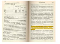
Production
| Company | Mine Name | Date | Production (tons) |
| Brookside Coal Company | Brookside | pre1881-1887 | 276,312 |
| Consolidated Coal Company of St. Louis | Brookside | 1887-1896 | 315,510 |
| Joseph Hardin | Brookside | 1896-1897 | 38,220 |
| Consolidated Coal Company of St. Louis | Brookside | 1897-1906 | 319,414 |
| Brookside Coal Company | Brookside | 1906-1912 | 166,019 |
| Total Production: 1,115,475 | |||
Production Notes
Coal Report production (if available)
Sources of Data
| Source Map | Map Date | Original Scale | Digitized Scale | Map Type |
| Microfilm, document 352345 | 6-22-1911 | 1:1200 | 1:2234 | Not final |
| State archive, IL_987 | 4-14-1914 | 1:1200 | 1:1200 | Final |
Annotated Bibliography (Data source - brief description of information)
| Coal Reports - Production, ownership, years of operation. |
| Directory of Illinois Coal Mines (Madison County) - Mine names, mine index, ownership, years of operation. |
| Mine notes (Madison County) - Mine type, shaft location, seam, depth, thickness. |
| Microfilm map, document 352345, reel 03138, frames 452, 453 - Shaft locations, mine outline, mining method. |
| State archive, IL_987 - Shaft locations, mine outline, mining method. |
Mine Notes
Mine Images


Photographs