2937: Difference between revisions
(Created page with "{{Sidebar Info Query}} {{Header |checked=1st Entry |unlocated=No |shown_on_map=Yes |Mine-index=2937 |Coal_co=L. Mustard |Mine Name Header=Mustard Mine |mine_type=Underground |indicated=No |county1=Macoupin |quad1=Franklin |Latitude=0 |Longitude=0 |Zoom=15 }} ==Shaft, Slope, Drift or Tipple Location(s)== {{Shaft locations header}} {{Shaft locations |shaft_type=Main shaft |County=Macoupin12N 9W |Town-Range=12N 9W |Section=4 }} ==Geology== {{Geology seam header}} {{Geolog...") |
No edit summary |
||
| Line 20: | Line 20: | ||
{{Shaft locations | {{Shaft locations | ||
|shaft_type=Main shaft | |shaft_type=Main shaft | ||
|County= | |County=Macoupin | ||
|Town-Range=12N 9W | |Town-Range=12N 9W | ||
|Section=4 | |Section=4 | ||
|partsection=SW NE NE or NE SW NE | |||
}} | }} | ||
==Geology== | ==Geology== | ||
Revision as of 17:22, March 3, 2023
Mine Index Number: 2937
| Company Name: | L. Mustard | ||
|---|---|---|---|
| Mine Name: | Mustard Mine | ||
| Start Date: | {{{year-start}}} | End Date: | {{{year-end}}} |
| Type of Mine: | Underground | ||
| Total acres shown: | |||
| Acres after map date: | General Area of mining acres shown: | ||
"{{{year-start}}}" contains an extrinsic dash or other characters that are invalid for a date interpretation."{{{year-end}}}" contains an extrinsic dash or other characters that are invalid for a date interpretation.
Shaft, Slope, Drift or Tipple Location(s)
| Type | County | Township-Range | Section | Part Section |
|---|
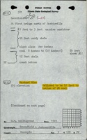
| Main shaft | Macoupin | 12N 9W | 4 | SW NE NE or NE SW NE |
Geology
| Thickness (ft) | |||||
|---|---|---|---|---|---|
| Seam | Depth (ft) | Min | Max | Ave | Mining Method |
| Herrin | 39-45 | 2.67 |
Geological Problems Reported
Production
| Company | Mine Name | Date | Production (tons) |
| L. Mustard The mine notes indicate that this mine operated 1918, but it was not listed under this name in the Coal Reports. Production and years of operation are unknown. | |||
Production Notes
Coal Report production (if available)
Sources of Data
| Source Map | Map Date | Original Scale | Digitized Scale | Map Type |
Annotated Bibliography (Data source - brief description of information)
| Coal Reports - Production, ownership, years of operation. |
| Directory of Illinois Coal Mines (Macoupin County) - Mine names, mine index, ownership, years of operation. |
| Mine notes (Macoupin County) - Mine type, shaft location, seam, depth, thickness. |
Mine Notes
Mine Images


Photographs