4459: Difference between revisions
(Created page with "{{Sidebar Info Query}} {{Header |checked=1st Entry |unlocated=No |shown_on_map=Yes |Mine-index=4459 |Coal_co=Unknown |county1=Williamson |quad1=Crab Orchard |Latitude=0 |Longi...") |
No edit summary |
||
| (One intermediate revision by one other user not shown) | |||
| Line 1: | Line 1: | ||
{{Sidebar Info Query}} | {{Sidebar Info Query}} | ||
{{Header | {{Header | ||
|checked= | |checked=Checked OK | ||
|unlocated=No | |unlocated=No | ||
|shown_on_map=Yes | |shown_on_map=Yes | ||
|Mine-index=4459 | |Mine-index=4459 | ||
|Coal_co=Unknown | |Coal_co=Unknown | ||
|Mine Name Header=Unknown Mine | |||
|mine_type=Surface | |||
|indicated=No | |||
|county1=Williamson | |county1=Williamson | ||
|quad1=Crab Orchard | |quad1=Crab Orchard | ||
|Latitude= | |year-start=9999 | ||
|Longitude= | |year-end=9999 | ||
|Latitude=37.70725052 | |||
|Longitude=-88.8114411 | |||
|Zoom=15 | |Zoom=15 | ||
}} | }} | ||
| Line 16: | Line 21: | ||
{{Shaft locations header}} | {{Shaft locations header}} | ||
{{Shaft locations | {{Shaft locations | ||
|shaft_type=Pit | |||
|County=Williamson | |County=Williamson | ||
|Town-Range=9S 4E | |Town-Range=9S 4E | ||
| Line 26: | Line 32: | ||
{{Geology seam | {{Geology seam | ||
|Seam=Herrin | |Seam=Herrin | ||
|thick-ave=6.0 | |||
|mining-method=Surface | |||
}} | }} | ||
===Geological Problems Reported=== | ===Geological Problems Reported=== | ||
| Line 39: | Line 47: | ||
{{Source map header}} | {{Source map header}} | ||
{{Source Map | {{Source Map | ||
|Source Map= | |Source Map=Mine notes | ||
|Map Date=Undated | |||
|Original Scale=(text only) | |||
|Digitized Scale=1:24000 {{#info:Point plotted onto 1:24,000 USGS topographic map and digitized.|note}} | |||
|Map Type=Secondary source | |||
}} | }} | ||
{{Source Map | {{Source Map | ||
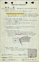
|Source Map=ISGS field notes (H. R. | |Source Map=ISGS field notes (H. R. Wanless) | ||
|Map Date=8-15-1932 | |Map Date=8-15-1932 | ||
|Original Scale=(text only) | |||
|Digitized Scale=1:24000 {{#info:Point plotted onto 1:24,000 USGS topographic map and digitized.|note}} | |||
|Map Type=Secondary source | |||
}} | }} | ||
{{Annotated bibliography header}} | {{Annotated bibliography header}} | ||
{{Annotated bibliography | |||
|bibliography=Mine notes (Williamson County) - Mine type, mine location, seam, thickness. | |||
}} | |||
{{Annotated bibliography | |||
|bibliography=ISGS field notes (Williamson County) - Mine type, mine location, seam. | |||
}} | |||
==Mine Notes== | ==Mine Notes== | ||
Latest revision as of 15:24, March 14, 2023
Mine Index Number: 4459
| Company Name: | Unknown | ||
|---|---|---|---|
| Mine Name: | Unknown Mine | ||
| Start Date: | Unknown | End Date: | Unknown |
| Type of Mine: | Surface | ||
| Total acres shown: | |||
| Acres after map date: | General Area of mining acres shown: | ||
Shaft, Slope, Drift or Tipple Location(s)
| Type | County | Township-Range | Section | Part Section |
|---|
| Pit | Williamson | 9S 4E | 30 | SW NE SW |
Geology
| Thickness (ft) | |||||
|---|---|---|---|---|---|
| Seam | Depth (ft) | Min | Max | Ave | Mining Method |
| Herrin | 6.0 | Surface |
Geological Problems Reported
Production
| Company | Mine Name | Date | Production (tons) |
Production Notes
Coal Report production (if available)
Sources of Data
| Source Map | Map Date | Original Scale | Digitized Scale | Map Type |
| Mine notes | Undated | (text only) | 1:24000 Point plotted onto 1:24,000 USGS topographic map and digitized. | Secondary source |
| ISGS field notes (H. R. Wanless) | 8-15-1932 | (text only) | 1:24000 Point plotted onto 1:24,000 USGS topographic map and digitized. | Secondary source |
Annotated Bibliography (Data source - brief description of information)
| Mine notes (Williamson County) - Mine type, mine location, seam, thickness. |
| ISGS field notes (Williamson County) - Mine type, mine location, seam. |
Mine Notes
Mine Images
Photographs