3615: Difference between revisions
No edit summary |
No edit summary |
||
| (4 intermediate revisions by 2 users not shown) | |||
| Line 4: | Line 4: | ||
|unlocated=No | |unlocated=No | ||
|shown_on_map=Yes | |shown_on_map=Yes | ||
|reason_nsm=Valley Mine was connected underground to Superior Mine (mine index [[0078]]) for haulage, as well as to Victor Mine (mine index [[4331]]). | |reason_nsm=Valley Mine was connected underground to Superior Mine (mine index [[0078]]) for haulage, Pollock Mine (mine index [[3498]]) for ventilation, as well as to Victor Mine (mine index [[4331]]). | ||
|Mine-index=3615 | |Mine-index=3615 | ||
|Coal_co=Superior Mining Company | |Coal_co=Superior Mining Company | ||
| Line 79: | Line 79: | ||
}} | }} | ||
{{Production | {{Production | ||
|Company=Superior Mining Company {{#info:The 1930 map's title block lists the operator as West Virginia Coal Company of Missouri. Production was not listed in the Coal Reports under that name.|note}} | |Company=Superior Mining Company | ||
|company_note={{#info:The 1930 map's title block lists the operator as West Virginia Coal Company of Missouri. Production was not listed in the Coal Reports under that name.|note}} | |||
|Mine-Name=Valley | |Mine-Name=Valley | ||
|Date=1918-1921 | |Date=1918-1921 | ||
| Line 110: | Line 111: | ||
}} | }} | ||
{{Annotated bibliography | {{Annotated bibliography | ||
|bibliography=State archive, IL_221 - Shaft locations, mine outline, method. | |bibliography=State archive, IL_221 - Shaft locations, mine outline, mining method. | ||
}} | }} | ||
{{Annotated bibliography | {{Annotated bibliography | ||
| Line 126: | Line 127: | ||
{{Editwithform}} | {{Editwithform}} | ||
{{Editwithform}} | {{Editwithform}} | ||
{{#set:Company=West Virginia Coal Company}} | |||
Latest revision as of 15:58, April 11, 2023
Mine Index Number: 3615
| Company Name: | Superior Mining Company | ||
|---|---|---|---|
| Mine Name: | Valley Mine | ||
| Start Date: | 1901 | End Date: | January 1921 |
| Type of Mine: | Underground | ||
| Total acres shown: | 104 | ||
| Acres after map date: | General Area of mining acres shown: | ||
|
Valley Mine was connected underground to Superior Mine (mine index 0078) for haulage, Pollock Mine (mine index 3498) for ventilation, as well as to Victor Mine (mine index 4331). | |||
Shaft, Slope, Drift or Tipple Location(s)
| Type | County | Township-Range | Section | Part Section |
|---|
| Main shaft | St. Clair | 2N 9W | 36 | SE SE SE |
| Air shaft | St. Clair | 2N 9W | 36 | SE SE SE |
Geology
| Thickness (ft) | |||||
|---|---|---|---|---|---|
| Seam | Depth (ft) | Min | Max | Ave | Mining Method |
| Herrin | 85 | 6.0-7.0 | RPB |
Geological Problems Reported
Production
| Company | Mine Name | Date | Production (tons) |
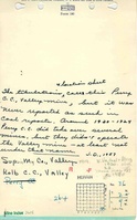
| Valley Coal and Mining Company | Valley | 1901-1907 | 362,196 |
| Kolb Coal Company | Valley | 1907-1915 Idle 1909, 1914, 1915. | 110,198 |
| White Coal Company | Valley | 1915-1917 | 69,180 |
| Beck and White Coal Company | Valley | 1917-1918 | 85,768 |
| Superior Mining Company The 1930 map's title block lists the operator as West Virginia Coal Company of Missouri. Production was not listed in the Coal Reports under that name. | Valley | 1918-1921 | 102,570 |
| Total Production: 729,912 | |||
Production Notes
Coal Report production (if available)
Sources of Data
| Source Map | Map Date | Original Scale | Digitized Scale | Map Type |
| State archive, IL_221 | 2-2-1930 | 1:2400 | 1:2400 | Final |
Annotated Bibliography (Data source - brief description of information)
| Coal Reports - Production, ownership, years of operation. |
| Directory of Illinois Coal Mines (St. Clair County) - Mine names, mine index, ownership, years of operation. |
| State archive, IL_221 - Shaft locations, mine outline, mining method. |
| Mine notes (St. Clair County) - Depth, seam, mine type, shaft location. |
Mine Notes
Mine Images

Photographs