4121: Difference between revisions
No edit summary |
Alan.Myers (talk | contribs) No edit summary |
||
| Line 16: | Line 16: | ||
|year-start=1889 | |year-start=1889 | ||
|year-end=1895 | |year-end=1895 | ||
|Latitude= | |Latitude=37.70360946 | ||
|Longitude= | |Longitude=-88.81749446 | ||
|Zoom=15 | |Zoom=15 | ||
}} | }} | ||
Latest revision as of 09:57, June 21, 2023
Mine Index Number: 4121
| Company Name: | George F. Motsinger | ||
|---|---|---|---|
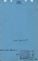
| Mine Name: | Edwards Bank | ||
| Start Date: | 1889 | End Date: | 1895 |
| Type of Mine: | Underground | ||
| Total acres shown: | None | ||
| Acres after map date: | 4 | General Area of mining acres shown: | |
|
Not Shown On Map. Not shown on accompanying map due to later surface mining. | |||
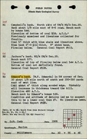
Shaft, Slope, Drift or Tipple Location(s)
| Type | County | Township-Range | Section | Part Section |
|---|
| Main drift | Williamson | 9S 4E | 30 | SW SW SW |
Geology
| Thickness (ft) | |||||
|---|---|---|---|---|---|
| Seam | Depth (ft) | Min | Max | Ave | Mining Method |
| Springfield | 5 | 4.0 | RP |
Geological Problems Reported
Production
| Company | Mine Name | Date | Production (tons) |
| Edwards Brothers | Edwards Bank | 1889-1890 | 400 |
| Cline and Edwards | Edwards Bank | 1890-1891 | 720 |
| George F. Motsinger | Edwards Bank | 1891-1895 | 22,985 |
| Total Production: 24,105 | |||
Production Notes
Coal Report production (if available)
Sources of Data
| Source Map | Map Date | Original Scale | Digitized Scale | Map Type |
| Mine notes | Undated | (text only) | 1:24000 Point plotted onto 1:24,000 USGS topographic map and digitized. | Secondary source |
| ISGS field notes (G. H. Cady) | 1908 | (text only) | 1:24000 Point plotted onto 1:24,000 USGS topographic map and digitized. | Secondary source |
Annotated Bibliography (Data source - brief description of information)
| Coal Reports - Production, ownership, years of operation, mining method. |
| Directory of Illinois Coal Mines (Williamson County) - Mine names, mine index, ownership, years of operation. |
| Mine notes (Williamson County) - Mine type, drift location, seam, depth, thickness. |
| ISGS field notes (Williamson County) - Mine location, ownership, thickness. |
Mine Notes
Mine Images
Photographs