0533: Difference between revisions
Alan.Myers (talk | contribs) m (Text replacement - "OFallon" to "O'Fallon") |
No edit summary |
||
| (8 intermediate revisions by 2 users not shown) | |||
| Line 1: | Line 1: | ||
{{Sidebar Info Query}} | {{Sidebar Info Query}} | ||
{{Header | {{Header | ||
|checked=Checked OK | |||
|unlocated=No | |unlocated=No | ||
|shown_on_map=Yes | |shown_on_map=Yes | ||
| Line 8: | Line 9: | ||
|mine_type=Underground | |mine_type=Underground | ||
|mined-out-area=3,835 | |mined-out-area=3,835 | ||
|indicated=No | |||
|county1=St. Clair | |county1=St. Clair | ||
|quad1=O'Fallon | |quad1=O'Fallon | ||
|year-start=1904 | |year-start=1904 | ||
|year-end=1960 | |year-end=June 1960 | ||
|Latitude=38.5854114470001 | |Latitude=38.5854114470001 | ||
|Longitude=-89.957037988 | |Longitude=-89.957037988 | ||
|Zoom=13 | |||
}} | }} | ||
==Shaft, Slope, Drift or Tipple Location(s)== | ==Shaft, Slope, Drift or Tipple Location(s)== | ||
| Line 23: | Line 26: | ||
|Town-Range=2N 8W | |Town-Range=2N 8W | ||
|Section=26 | |Section=26 | ||
|partsection= | |partsection=SE SE SW | ||
}} | }} | ||
{{Shaft locations | {{Shaft locations | ||
| Line 58: | Line 61: | ||
|Date=1904-1915 | |Date=1904-1915 | ||
|Production=1,554,245 | |Production=1,554,245 | ||
|Sum=No | |||
}} | }} | ||
{{Production | {{Production | ||
| Line 64: | Line 68: | ||
|Date=1915-1916 | |Date=1915-1916 | ||
|Production=19,026 | |Production=19,026 | ||
|Sum=No | |||
}} | }} | ||
{{Production | {{Production | ||
| Line 70: | Line 75: | ||
|Date=1916-1918 | |Date=1916-1918 | ||
|Production=658,991 | |Production=658,991 | ||
|Sum=No | |||
}} | }} | ||
{{Production | {{Production | ||
| Line 76: | Line 82: | ||
|Date=1918-1921 | |Date=1918-1921 | ||
|Production=1,109,245 | |Production=1,109,245 | ||
|Sum=No | |||
}} | }} | ||
{{Production | {{Production | ||
| Line 82: | Line 89: | ||
|Date=1921-1957 {{#info: Idle July 1924 to June 1925|note}} | |Date=1921-1957 {{#info: Idle July 1924 to June 1925|note}} | ||
|Production=14,483,445 | |Production=14,483,445 | ||
|Sum=No | |||
}} | }} | ||
{{Production | {{Production | ||
| Line 88: | Line 96: | ||
|Date=1957-1960 | |Date=1957-1960 | ||
|Production=4,124,452 | |Production=4,124,452 | ||
|Sum=No | |||
| | |||
}} | }} | ||
{{Production | {{Production | ||
|Production=21,949,404 | |Production=21,949,404 | ||
|Sum=Yes | |||
}} | }} | ||
===Production Notes=== | ===Production Notes=== | ||
| Line 116: | Line 123: | ||
}} | }} | ||
{{Annotated bibliography | {{Annotated bibliography | ||
|bibliography= | |bibliography=Mine notes (St. Clair County) - Shaft location, mine type, seam, thickness. | ||
}} | }} | ||
{{Annotated bibliography | {{Annotated bibliography | ||
|bibliography= | |bibliography=Federal Land Bank Report (St. Clair County) - Depth, thickness. | ||
}} | }} | ||
{{Annotated bibliography | {{Annotated bibliography | ||
|bibliography= | |bibliography=Company map, ISGS map library, 4103.S31 i5.1-54 - Shaft and slope locations, mine outline, method. | ||
}} | }} | ||
==Mine Notes== | ==Mine Notes== | ||
Latest revision as of 15:29, July 18, 2023
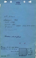
Mine Index Number: 0533
| Company Name: | Peabody Coal Company | ||
|---|---|---|---|
| Mine Name: | St. Ellen Mine | ||
| Start Date: | 1904 | End Date: | June 1960 |
| Type of Mine: | Underground | ||
| Total acres shown: | 3,835 | ||
| Acres after map date: | General Area of mining acres shown: | ||
Shaft, Slope, Drift or Tipple Location(s)
| Type | County | Township-Range | Section | Part Section |
|---|
| Shaft | St. Clair | 2N 8W | 26 | SE SE SW |
| Slope | St. Clair | 2N 8W | 35 | NW NW NE |
| Air shaft | St. Clair | 2N 7W | 31 | SW NE SW |
Geology
| Thickness (ft) | |||||
|---|---|---|---|---|---|
| Seam | Depth (ft) | Min | Max | Ave | Mining Method |
| Herrin | 210 | 7.0-7.5 | MRP |
Geological Problems Reported
Production
| Company | Mine Name | Date | Production (tons) |
| Joseph Taylor Coal Company | St. Ellen | 1904-1915 | 1,554,245 |
| Fisher Fuel Company | St. Ellen | 1915-1916 | 19,026 |
| St. Ellen Coal Company | St. Ellen | 1916-1918 | 658,991 |
| Perry County Coal Corporation | St. Ellen | 1918-1921 | 1,109,245 |
| Perry Coal Company | St. Ellen | 1921-1957 Idle July 1924 to June 1925 | 14,483,445 |
| Peabody Coal Company | St. Ellen | 1957-1960 | 4,124,452 |
| Total Production: 21,949,404 | |||
Production Notes
Coal Report production (if available)
Sources of Data
| Source Map | Map Date | Original Scale | Digitized Scale | Map Type |
| Company, 4103.S31 i5.1-54 | 5-21-1960 | 1:4800 | 1:4800 | Final |
Annotated Bibliography (Data source - brief description of information)
| Coal Reports - Production, ownership, years of operation. |
| Directory of Illinois Coal Mines (St. Clair County) - Mine names, mine index, ownership, years of operation. |
| Mine notes (St. Clair County) - Shaft location, mine type, seam, thickness. |
| Federal Land Bank Report (St. Clair County) - Depth, thickness. |
| Company map, ISGS map library, 4103.S31 i5.1-54 - Shaft and slope locations, mine outline, method. |
Mine Notes
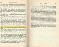
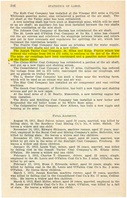
Mine Images
![[[:St. Ellen|St. Ellen]]](https://wikiimage.isgs.illinois.edu/ilmines/st_clair/thumbnails/m0533-2_th.jpg)
![[[:St. Ellen|St. Ellen]]](https://wikiimage.isgs.illinois.edu/ilmines/st_clair/thumbnails/m0533-1_th.jpg)
Photographs