3518: Difference between revisions
No edit summary |
No edit summary |
||
| (7 intermediate revisions by 4 users not shown) | |||
| Line 1: | Line 1: | ||
{{Sidebar Info Query}} | {{Sidebar Info Query}} | ||
{{Header | {{Header | ||
|checked=Checked OK | |||
|unlocated=No | |unlocated=No | ||
|shown_on_map=Yes | |shown_on_map=Yes | ||
|reason_nsm=The source map for the Consolidated Coal Company of St. Louis mines in this area is very poor, and the boundaries between the separate mines could not be distinguished. The acreage reported is the total for mine index numbers [[3513]], [[3515]], [[3517]] and [[3518]]. | |||
|Mine-index=3518 | |Mine-index=3518 | ||
|Coal_co=Consolidated Coal Company | |Coal_co=Consolidated Coal Company | ||
|Mine Name Header=Schureman Mine | |Mine Name Header=Schureman Mine | ||
|mine_type=Underground | |mine_type=Underground | ||
|mined-out-area=516 | |mined-out-area=516 | ||
|indicated=No | |||
|county1=St. Clair | |county1=St. Clair | ||
|quad1=French Village | |quad1=French Village | ||
|quad2=O'Fallon | |quad2=O'Fallon | ||
|datemod= | |datemod=Pre | ||
|year-start=1874 | |year-start=1874 | ||
|year-end=1905 | |year-end=1905 | ||
|Latitude=38.5309140910001 | |Latitude=38.5309140910001 | ||
|Longitude=-90.0177418869999 | |Longitude=-90.0177418869999 | ||
|Zoom=13 | |||
}} | }} | ||
==Shaft, Slope, Drift or Tipple Location(s)== | ==Shaft, Slope, Drift or Tipple Location(s)== | ||
| Line 33: | Line 37: | ||
|Section=17 | |Section=17 | ||
|partsection=NW SE NE | |partsection=NW SE NE | ||
}} | |||
{{Shaft locations | |||
|shaft_type=Shaft | |||
|County=St. Clair | |||
|Town-Range=1N 8W | |||
|Section=17 | |||
|partsection=SW NE SW | |||
}} | |||
{{Shaft locations | |||
|shaft_type=Shaft | |||
|County=St. Clair | |||
|Town-Range=1N 8W | |||
|Section=17 | |||
|partsection=NW SE SW | |||
}} | }} | ||
==Geology== | ==Geology== | ||
| Line 53: | Line 71: | ||
|Date=pre1874-1886 | |Date=pre1874-1886 | ||
|Production=121,359 {{#info: Production and ownership prior to 1882 are unknown. The Coal Report of 1882 indicates 120 acres were mined. The Coal Report of 1884 stated that the Skellett Mine was adjacent to and operated co-jointly with the Schureman mine. Because the source maps of this area are poor and the boundary between the two mines cannot be distinguished, the Skellett mine was not given a separate index number.|note}} | |Production=121,359 {{#info: Production and ownership prior to 1882 are unknown. The Coal Report of 1882 indicates 120 acres were mined. The Coal Report of 1884 stated that the Skellett Mine was adjacent to and operated co-jointly with the Schureman mine. Because the source maps of this area are poor and the boundary between the two mines cannot be distinguished, the Skellett mine was not given a separate index number.|note}} | ||
|Sum=No | |||
}} | }} | ||
{{Production | {{Production | ||
| Line 59: | Line 78: | ||
|Date=1886-1887 | |Date=1886-1887 | ||
|Production=9,519 {{#info: Production and ownership prior to 1882 are unknown. The Coal Report of 1882 indicates 120 acres were mined. The Coal Report of 1884 stated that the Skellett Mine was adjacent to and operated co-jointly with the Schureman mine. Because the source maps of this area are poor and the boundary between the two mines cannot be distinguished, the Skellett mine was not given a separate index number.|note}} | |Production=9,519 {{#info: Production and ownership prior to 1882 are unknown. The Coal Report of 1882 indicates 120 acres were mined. The Coal Report of 1884 stated that the Skellett Mine was adjacent to and operated co-jointly with the Schureman mine. Because the source maps of this area are poor and the boundary between the two mines cannot be distinguished, the Skellett mine was not given a separate index number.|note}} | ||
|Sum=No | |||
}} | }} | ||
{{Production | {{Production | ||
| Line 64: | Line 84: | ||
|Mine-Name=Schureman | |Mine-Name=Schureman | ||
|Date=pre1882-1886 | |Date=pre1882-1886 | ||
|Production=159,766 {{#info: Production and ownership prior to 1882 are unknown. The Coal Report of 1882 indicates 30 acres mined.|note}} | |Production=159,766 {{#info: Production and ownership prior to 1882 are unknown. The Coal Report of 1882 indicates 30 acres were mined.|note}} | ||
|Sum=No | |||
}} | }} | ||
{{Production | {{Production | ||
| Line 71: | Line 92: | ||
|Date=1886-1896 | |Date=1886-1896 | ||
|Production=543,893 | |Production=543,893 | ||
|Sum=No | |||
}} | }} | ||
{{Production | {{Production | ||
| Line 78: | Line 100: | ||
|Date=1896-1897 | |Date=1896-1897 | ||
|Production=48,647 | |Production=48,647 | ||
|Sum=No | |||
}} | }} | ||
{{Production | {{Production | ||
| Line 84: | Line 107: | ||
|Date=1897-1905 | |Date=1897-1905 | ||
|Production=348,836 | |Production=348,836 | ||
|Sum=No | |||
| | |||
}} | }} | ||
{{Production | {{Production | ||
|Production=1,232,020 | |Production=1,232,020 | ||
|Sum=Yes | |||
}} | }} | ||
===Production Notes=== | ===Production Notes=== | ||
| Line 129: | Line 151: | ||
}} | }} | ||
{{Annotated bibliography | {{Annotated bibliography | ||
|bibliography=Atlas of St. Clair County, Illinois, 1874, Warner and Beers, Chicago, Illinois - Skellett shaft location, years of operation | |bibliography=Atlas of St. Clair County, Illinois, 1874, Warner and Beers, Chicago, Illinois - Skellett shaft location, years of operation; years of operation of Schureman shaft. | ||
}} | }} | ||
{{Annotated bibliography | {{Annotated bibliography | ||
Latest revision as of 14:45, July 24, 2023
Mine Index Number: 3518
| Company Name: | Consolidated Coal Company | ||
|---|---|---|---|
| Mine Name: | Schureman Mine | ||
| Start Date: | Pre 1874 | End Date: | 1905 |
| Type of Mine: | Underground | ||
| Total acres shown: | 516 | ||
| Acres after map date: | General Area of mining acres shown: | ||
|
The source map for the Consolidated Coal Company of St. Louis mines in this area is very poor, and the boundaries between the separate mines could not be distinguished. The acreage reported is the total for mine index numbers 3513, 3515, 3517 and 3518. | |||
Shaft, Slope, Drift or Tipple Location(s)
| Type | County | Township-Range | Section | Part Section |
|---|
| Main shaft | St. Clair | 1N 8W | 17 | SE NW SW |
| Skellet shaft | St. Clair | 1N 8W | 17 | NW SE NE |
| Shaft | St. Clair | 1N 8W | 17 | SW NE SW |
| Shaft | St. Clair | 1N 8W | 17 | NW SE SW |
Geology
| Thickness (ft) | |||||
|---|---|---|---|---|---|
| Seam | Depth (ft) | Min | Max | Ave | Mining Method |
| Herrin | 125-150 | 6.0-6.5 | RPB |
Geological Problems Reported
Production
| Company | Mine Name | Date | Production (tons) |
| William Skellett | Skellett | pre1874-1886 | 121,359 Production and ownership prior to 1882 are unknown. The Coal Report of 1882 indicates 120 acres were mined. The Coal Report of 1884 stated that the Skellett Mine was adjacent to and operated co-jointly with the Schureman mine. Because the source maps of this area are poor and the boundary between the two mines cannot be distinguished, the Skellett mine was not given a separate index number. |
| Consolidated Coal Company of St. Louis | Skellett | 1886-1887 | 9,519 Production and ownership prior to 1882 are unknown. The Coal Report of 1882 indicates 120 acres were mined. The Coal Report of 1884 stated that the Skellett Mine was adjacent to and operated co-jointly with the Schureman mine. Because the source maps of this area are poor and the boundary between the two mines cannot be distinguished, the Skellett mine was not given a separate index number. |
| Schureman Brothers | Schureman | pre1882-1886 | 159,766 Production and ownership prior to 1882 are unknown. The Coal Report of 1882 indicates 30 acres were mined. |
| Consolidated Coal Company of St. Louis | Schureman | 1886-1896 | 543,893 |
| T. Westwood , lessee | Schureman | 1896-1897 | 48,647 |
| Consolidated Coal Company | Schureman | 1897-1905 | 348,836 |
| Total Production: 1,232,020 | |||
Production Notes
Coal Report production (if available)
Sources of Data
| Source Map | Map Date | Original Scale | Digitized Scale | Map Type |
| Microfilm, document 350961 | 3-30-1910 | 1:2400 | 1:5297 | Final |
| Atlas of St. Clair County | 1874 | 1:36205 | 1:36205 | Secondary source |
| ISGS field notes (G. H. Cady) | Undated | 1:62500 | 1:62500 | Secondary source |
Annotated Bibliography (Data source - brief description of information)
| Coal Reports - Production, ownership, years of operation. |
| Directory of Illinois Coal Mines (St. Clair County) - Mine names, mine index, ownership, years of operation. |
| Mine notes (St. Clair County) - Shaft location, mine type, seam, depth, thickness. |
| Atlas of St. Clair County, Illinois, 1874, Warner and Beers, Chicago, Illinois - Skellett shaft location, years of operation; years of operation of Schureman shaft. |
| Microfilm map, document 350961, reel 03134, frame 4 - Shaft locations, mine outline, mining method. |
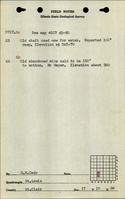
| ISGS field notes (St. Clair County) - Shaft locations (SW NE SW and NW SE SW). |
Mine Notes
Mine Images


Photographs