2097: Difference between revisions
(Created page with "{{Sidebar Info Query}} {{Header |checked=1st Entry |unlocated=No |shown_on_map=Yes |Mine-index=2097 |Coal_co=Clio C. Branson |Mine Name Header=Branson Mine |mine_type=Undergro...") |
No edit summary |
||
| (2 intermediate revisions by 2 users not shown) | |||
| Line 1: | Line 1: | ||
{{Sidebar Info Query}} | {{Sidebar Info Query}} | ||
{{Header | {{Header | ||
|checked= | |checked=Checked OK | ||
|unlocated=No | |unlocated=No | ||
|shown_on_map=Yes | |shown_on_map=Yes | ||
| Line 13: | Line 13: | ||
|county1=Fulton | |county1=Fulton | ||
|quad1=Ipava | |quad1=Ipava | ||
|city1=Ipava | |||
|city2=Summum | |||
|year-start=1934 | |year-start=1934 | ||
|year-end=April 1, 1939 | |year-end=April 1, 1939 | ||
|Latitude= | |Latitude=40.34195234 | ||
|Longitude= | |Longitude=-90.30418993 | ||
|Zoom=15 | |Zoom=15 | ||
}} | }} | ||
| Line 50: | Line 52: | ||
}} | }} | ||
{{Production | {{Production | ||
|Company=Harris Wrestler | |Company=Harris and Wrestler | ||
|Mine-Name=Wrestler | |Mine-Name=Harris and Wrestler | ||
|Date=1936-1937 {{#info: Idle 1937 |note}} | |Date=1936-1937 {{#info: Idle 1937 |note}} | ||
|Production=86 | |Production=86 | ||
Latest revision as of 16:13, July 26, 2023
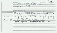
Mine Index Number: 2097
| Company Name: | Clio C. Branson | ||
|---|---|---|---|
| Mine Name: | Branson Mine | ||
| Start Date: | 1934 | End Date: | April 1, 1939 |
| Type of Mine: | Underground | ||
| Total acres shown: | None | ||
| Production Indicated Acres: | Less than 1 | General Area of mining acres shown: | |
Shaft, Slope, Drift or Tipple Location(s)
| Type | County | Township-Range | Section | Part Section |
|---|
| Main drift | Fulton | 4N 2E | 8 |
Geology
| Thickness (ft) | |||||
|---|---|---|---|---|---|
| Seam | Depth (ft) | Min | Max | Ave | Mining Method |
| Springfield | 30 | 4.0-6.0 | RP |
Geological Problems Reported
Production
| Company | Mine Name | Date | Production (tons) |
| Elzie Wrestler | Wrestler | 1934-1935 | 230 |
| Harris and Wrestler | Harris and Wrestler | 1936-1937 Idle 1937 | 86 |
| Clio C. Branson | Branson | 1938-1939 | 239 The 1939 production was from pulling pillars. |
| Total Production: 555 | |||
Production Notes
Coal Report production (if available)
Sources of Data
| Source Map | Map Date | Original Scale | Digitized Scale | Map Type |
| Mine notes | Undated | 1:62500 | 1:62500 | Secondary source |
Annotated Bibliography (Data source - brief description of information)
| Coal Reports - Production, ownership, years of operation. |
| Directory of Illinois Coal Mines (Fulton County) - Mine names, mine index, ownership, years of operation. |
| Mine notes (Fulton County) - Mine type, drift location, seam, depth, thickness. |
| Mine Inspector's reports, courtesy of Joe Pelc, IDNR - Mine type, seam, thickness, mining method. |
Mine Notes
Mine Images
Photographs