0080: Difference between revisions
No edit summary |
No edit summary |
||
| Line 4: | Line 4: | ||
|unlocated=No | |unlocated=No | ||
|shown_on_map=Yes | |shown_on_map=Yes | ||
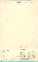
|reason_nsm=The area shown on the accompanying map is approximately 35 acres larger than expected for the reported production. The boundary between the Eureka No. 1 Mine (mine index [[3622]]) and the Gill Mine is not clear. It is likely that area depicted on the accompanying map as Gill Mine contains areas mined by Eureka No. 1 Mine. | |||
|Mine-index=0080 | |Mine-index=0080 | ||
|Coal_co=Gill Coal Corporation | |Coal_co=Gill Coal Corporation | ||
|Mine Name Header=Gill Mine | |Mine Name Header=Gill Mine | ||
|mine_type=Underground | |mine_type=Underground | ||
|mined-out-area=287 | |mined-out-area=287 | ||
|after_map=2 | |after_map=2 | ||
|indicated=No | |indicated=No | ||
| Line 132: | Line 133: | ||
{{Source map header}} | {{Source map header}} | ||
{{Source Map | {{Source Map | ||
|Source Map=State | |Source Map=State archive, IL_392_01 | ||
|Map Date=3-1-1937 | |Map Date=3-1-1937 | ||
|Original Scale=1:2400 | |Original Scale=1:2400 | ||
Latest revision as of 15:22, January 9, 2024
Mine Index Number: 0080
| Company Name: | Gill Coal Corporation | ||
|---|---|---|---|
| Mine Name: | Gill Mine | ||
| Start Date: | 1899 | End Date: | March 1937 |
| Type of Mine: | Underground | ||
| Total acres shown: | 287 | ||
| Acres after map date: | 2 | General Area of mining acres shown: | |
|
The area shown on the accompanying map is approximately 35 acres larger than expected for the reported production. The boundary between the Eureka No. 1 Mine (mine index 3622) and the Gill Mine is not clear. It is likely that area depicted on the accompanying map as Gill Mine contains areas mined by Eureka No. 1 Mine. | |||
Shaft, Slope, Drift or Tipple Location(s)
| Type | County | Township-Range | Section | Part Section |
|---|
| Main shaft (6 x 12 feet) | St. Clair | 3S 6W | 27 | SW SW NE |
| Air shaft | St. Clair | 3S 6W | 27 | NE NE SW |
Geology
| Thickness (ft) | |||||
|---|---|---|---|---|---|
| Seam | Depth (ft) | Min | Max | Ave | Mining Method |
| Herrin | 99-105 | 6.0 | 8.5 | 6.75 | MRP |
Geological Problems Reported
Some rolls and slips were present, but the coal was never completely cut out by the rolls. The immediate roof above the coal varied. The cap rock was limestone up to 5 feet thick. Sometimes shale was present below the limestone. The shale ranged up to 15 feet thick. Draw slate was also present in some areas, and was generally less than 14 inches thick. The coal seam contained several layers with streaks of pyrite and bone coal less than 1 inch thick with thicker layers of dirty coal up to 1.5 feet thick. Bone coal and pyrite were not loaded with the coal mined. The floor was fire clay that ranged from 4 to over 6 feet thick.
Production
| Company | Mine Name | Date | Production (tons) |
| Superior Coal Company The name changed because a Superior Coal Company was already operating at another location along the same railroad. The ownership of Borders Coal Company and Superior Coal Company was the same. | Superior | 1899-1900 | None reported |
| Borders Coal Company The name changed because a Superior Coal Company was already operating at another location along the same railroad. The ownership of Borders Coal Company and Superior Coal Company was the same. | Borders | 1900-1913 | 853,241 |
| Forsythe Coal Company | Forsythe | 1913-1915 | 64,348 |
| Dozow Valley Coal Company | Dozow Valley | 1915-1916 | 32,060 |
| Forsythe Coal Company | Dozow Valley | 1916-1919 | 211,163 |
| New Marissa Coal Company | New Marissa | 1919-1922 | 204,003 |
| Lyle Coal Company In 1926, the mine was leased to Wallace Coal Company. | Lyle | 1922-1931 | 460,429 Idle 1930 & 1931 |
| Gill Coal Corporation | Gill | 1931-1937 | 171,014 |
| Gill Coal Corporation | Gill | 1937-1937 | 10,278 Production after map date |
| Total Production: 2,066,536 | |||
Production Notes
Coal Report production (if available)
Sources of Data
| Source Map | Map Date | Original Scale | Digitized Scale | Map Type |
| State archive, IL_392_01 | 3-1-1937 | 1:2400 | 1:2400 | Not final |
Annotated Bibliography (Data source - brief description of information)
| Coal Reports - Production, ownership, years of operation. |
| Mine notes (St. Clair County) - Mine type, shaft size & location, seam, depth, thickness, geologic problems. |
| State archive, IL_392_01 - Shaft locations, mine outline, mining method. |
Mine Notes
Mine Images
![[[:Lyle|Lyle]]](https://wikiimage.isgs.illinois.edu/ilmines/st_clair/thumbnails/m0080_IL_392_01_th.jpg)
Photographs