Mine Index Number: 3622
| Company Name:
|
Jones Brothers Coal and Mining Company
|
| Mine Name:
|
Eureka No. 1 Mine
|
| Start Date:
|
1898
|
End Date:
|
February 1934
|
| Type of Mine:
|
Underground
|
| Total acres shown:
|
242
|
| Acres after map date:
|
|
General Area of mining acres shown:
|
|
|
Production indicates that approximately 274 acres were mined. The boundary between the Gill Mine (mine index 0080) and the Eureka Mine is not clear. It is likely that area depicted on the accompanying map as Gill Mine contains areas mined by Eureka No. 1 Mine.
|
Shaft, Slope, Drift or Tipple Location(s)
| Type
|
County
|
Township-Range
|
Section
|
Part Section
|
| Main shaft (6 x 6.5 feet)
|
St. Clair
|
3S 6W
|
27
|
NE NW SE
|
| Air shaft
|
St. Clair
|
3S 6W
|
27
|
NE NW SE
|
Geology
Geological Problems Reported
The immediate roof was 0 to 4 feet of shale, with limestone above. The floor was over 2 feet of fire clay.
Production
| Company
|
Mine Name
|
Date
|
Production (tons)
|
|
|
|
|
|
| Total Production: 1,607,417
|
Production Notes
Coal Report production (if available)
Sources of Data
| WPA, T3S-R6W
|
circa 1934
|
1:12000
|
1:63360
|
Secondary source
|
Annotated Bibliography (Data source - brief description of information)
| Coal Reports - Production, ownership, years of operation, mining method.
|
| Directory of Illinois Coal Mines (St. Clair County) - Mine names, mine index, ownership, years of operation.
|
| Mine notes (St. Clair County) - Mine type, shaft location & size, seam, depth, thickness, geologic problems.
|
| WPA, T3S-R6W - Shaft locations, mine outline.
|
Mine Notes
Mine Images
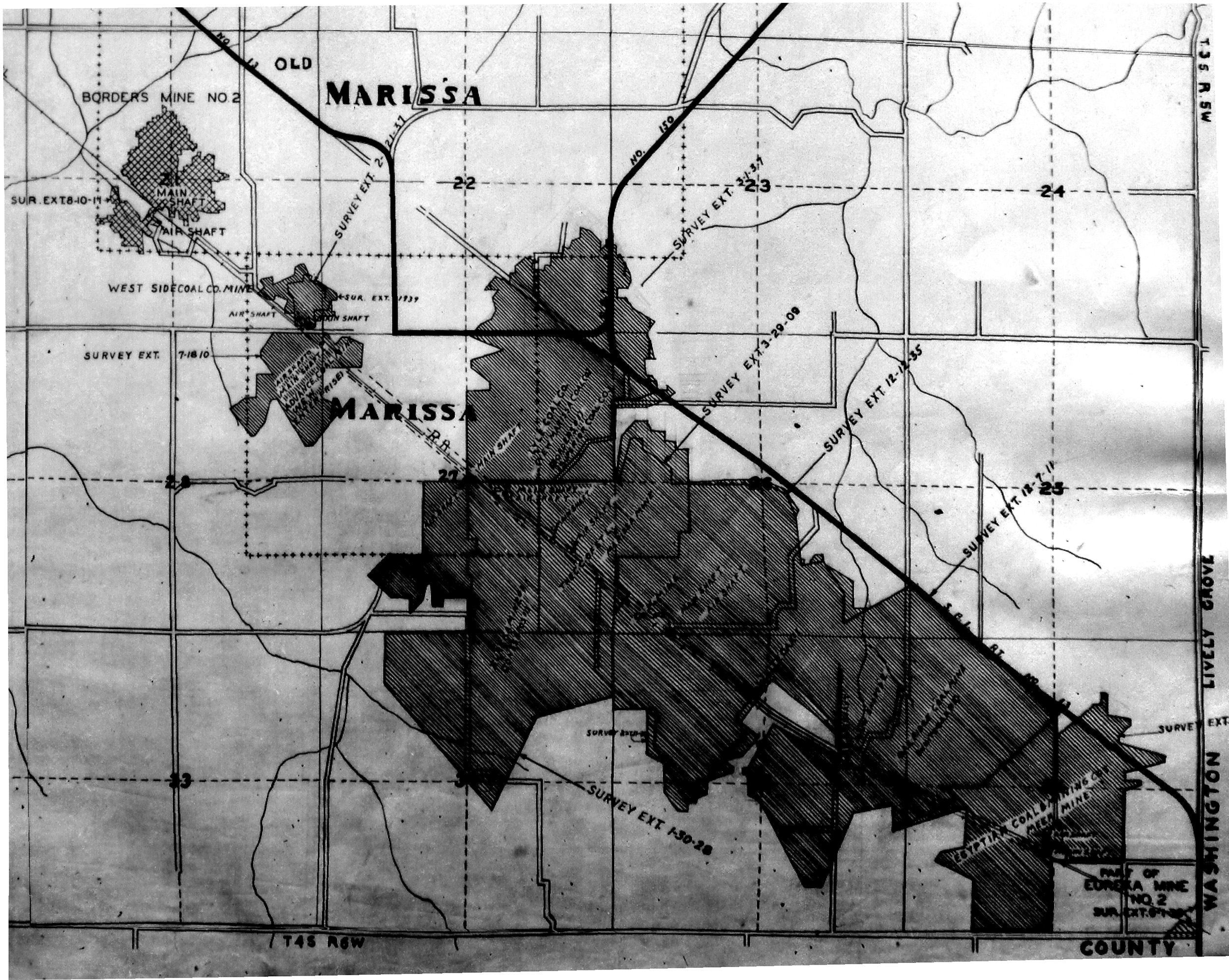 These files may not be true to scale and are not georgistered. These files may not be true to scale and are not georgistered.
|
Map Type:
|
WPA
|
| Map ID:
|
|
| Company:
|
|
| Mine Name:
|
|
| Caption:
|
|
| Map Date:
|
1934
|
| Map Status:
|
T3S-R6W
|
| Image Credit:
|
|
| Note:
|
Clipped version of the WPA
|
| More Info:
|
Marissa wpa
|
| Full Res Download:These files are true to scale and most are georegistered for gis software. These files may be a very large (>1GB) download!
|
https://wikiimage.isgs.illinois.edu/ilmines/st clair/marissa wpa.zip
|
Photographs