3625: Difference between revisions
Alan.Myers (talk | contribs) No edit summary |
No edit summary |
||
| (One intermediate revision by the same user not shown) | |||
| Line 4: | Line 4: | ||
|unlocated=No | |unlocated=No | ||
|shown_on_map=Yes | |shown_on_map=Yes | ||
|reason_nsm=The area shown on the accompanying map includes the area mined for White Oak No. 1 Mine (mine index [[3627]]). The boundary between the two mines could not be discerned. According to the source maps, Oak Ridge Mine (White Oak No. 2 Mine) was generally north of the railroad, while White Oak No. 1 Mine was generally south of the railroad. With the area mined before reported production for White Oak No. 1 Mine, production indicates approximately 320 acres were mined. <br><br> A fire burned the tipple, engine house and boiler house. | |||
|Mine-index=3625 | |Mine-index=3625 | ||
|Coal_co=Egyptian Coal and Mining Company | |Coal_co=Egyptian Coal and Mining Company | ||
|Mine Name Header=Oak Ridge Mine | |Mine Name Header=Oak Ridge Mine | ||
|mine_type=Underground | |mine_type=Underground | ||
|mined-out-area= | |mined-out-area=239 | ||
|indicated=No | |indicated=No | ||
|county1=St. Clair | |county1=St. Clair | ||
|quad1=Tilden | |quad1=Tilden | ||
|year-start=1882 | |year-start=1882 | ||
|year-end=1912 | |year-end=July 12, 1912 | ||
|Latitude=38.2308943530001 | |Latitude=38.2308943530001 | ||
|Longitude=-89.73157875 | |Longitude=-89.73157875 | ||
| Line 22: | Line 23: | ||
{{Shaft locations header}} | {{Shaft locations header}} | ||
{{Shaft locations | {{Shaft locations | ||
|shaft_type=Main shaft (7.5 x 14 ft) {{#info: No air shafts were shown on the source maps. It is likely that ventilation was provided by underground connection with White Oak No. 1 Mine (mine index 3627).|note}} | |shaft_type=Main shaft (7.5 x 14 ft) {{#info: No air shafts were shown on the source maps. It is likely that ventilation was provided by underground connection with White Oak No. 1 Mine (mine index [[3627]]).|note}} | ||
|County=St. Clair | |County=St. Clair | ||
|Town-Range=3S 6W | |Town-Range=3S 6W | ||
| Line 140: | Line 141: | ||
{{Source map header}} | {{Source map header}} | ||
{{Source Map | {{Source Map | ||
|Source Map= | |Source Map=State archive, IL_122_01 | ||
|Map Date=8-27-1920 | |Map Date=8-27-1920 | ||
|Original Scale=1:2400 | |Original Scale=1:2400 | ||
|Digitized Scale=1: | |Digitized Scale=1:2400 | ||
|Map Type=Final | |Map Type=Final | ||
}} | }} | ||
| Line 164: | Line 165: | ||
}} | }} | ||
{{Annotated bibliography | {{Annotated bibliography | ||
|bibliography= | |bibliography=State archive, IL_122_01 - Shaft location, mine outline, mining method. | ||
}} | }} | ||
{{Annotated bibliography | {{Annotated bibliography | ||
Latest revision as of 15:26, January 24, 2024
Mine Index Number: 3625
| Company Name: | Egyptian Coal and Mining Company | ||
|---|---|---|---|
| Mine Name: | Oak Ridge Mine | ||
| Start Date: | 1882 | End Date: | July 12, 1912 |
| Type of Mine: | Underground | ||
| Total acres shown: | 239 | ||
| Acres after map date: | General Area of mining acres shown: | ||
|
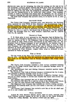
The area shown on the accompanying map includes the area mined for White Oak No. 1 Mine (mine index 3627). The boundary between the two mines could not be discerned. According to the source maps, Oak Ridge Mine (White Oak No. 2 Mine) was generally north of the railroad, while White Oak No. 1 Mine was generally south of the railroad. With the area mined before reported production for White Oak No. 1 Mine, production indicates approximately 320 acres were mined. | |||
Shaft, Slope, Drift or Tipple Location(s)
| Type | County | Township-Range | Section | Part Section |
|---|
| Main shaft (7.5 x 14 ft) No air shafts were shown on the source maps. It is likely that ventilation was provided by underground connection with White Oak No. 1 Mine (mine index 3627). | St. Clair | 3S 6W | 35 | SW SE NE |
Geology
| Thickness (ft) | |||||
|---|---|---|---|---|---|
| Seam | Depth (ft) | Min | Max | Ave | Mining Method |
| Herrin | 156 | 5.5 | 7.5 | 6.5 | RP |
Geological Problems Reported
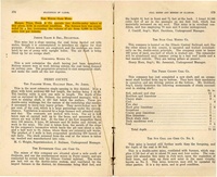
The roof was 6 inches to 2 feet of shale beneath 14 feet of limestone. Slips were common in the white top above the coal. The coal contained considerable pyrite. The underclay was generally 6 to 10 inches thick, but ranged from 3 inches to 4 feet.
Production
| Company | Mine Name | Date | Production (tons) |
| Dishew | White Oak No. 2 | 1882-1883 | Not reported |
| Tijou, Donk and Company | White Oak No. 2 | 1883-1884 | 40,000 |
| White Oak Coal Company | White Oak No. 2 | 1884-1885 | 20,570 |
| Tijou, Donk and Company | White Oak No. 2 | 1885-1886 | 35,000 |
| Consolidated Coal Company of St. Louis | White Oak No. 2 | 1886-1896 | 564,062 |
| Robert Forsythe | White Oak No. 2 | 1896-1897 | 30,749 |
| Consolidated Coal Company of St. Louis | White Oak No. 2 | 1897-1904 | 384,034 |
| Marissa Coal and Mining Company | Oak Ridge | 1904-1905 | 34,816 |
| Avery Coal Company | Oak Ridge | 1905-1906 | 24,211 |
| Oak Ridge Coal Company | Oak Ridge | 1906-1907 | 41,444 |
| Bessemer Washed Coal Company | Oak Ridge | 1907-1911 | 450,965 |
| Egyptian Coal and Mining Company | Oak Ridge | 1911-1912 | 36,407 |
| Total Production: 1,662,258 | |||
Production Notes
Coal Report production (if available)
Sources of Data
| Source Map | Map Date | Original Scale | Digitized Scale | Map Type |
| State archive, IL_122_01 | 8-27-1920 | 1:2400 | 1:2400 | Final |
| Microfilm, document 351006 | 12-30-1885 | 1:1200 | 1:1075 | Not final |
Annotated Bibliography (Data source - brief description of information)
| Coal Reports - Production, ownership, years of operation, mining method. |
| Directory of Illinois Coal Mines (St. Clair County) - Mine names, mine index, ownership, years of operation. |
| Mine notes (St. Clair County) - Mine type, shaft location & size, seam, depth, thickness, geologic problems. |
| State archive, IL_122_01 - Shaft location, mine outline, mining method. |
| Microfilm map, document 351006, reel 03134, frame 76 - Shaft identification. |
Mine Notes
Mine Images
![[[:Meeks No. 2|Meeks No. 2]]](https://wikiimage.isgs.illinois.edu/ilmines/st_clair/thumbnails/m0205_IL_122_01_th.jpg)
![[[:White Oak No. 2|White Oak No. 2]]](https://wikiimage.isgs.illinois.edu/ilmines/st_clair/thumbnails/m3625.jpg)
Photographs