3627: Difference between revisions
Alan.Myers (talk | contribs) No edit summary |
No edit summary |
||
| (6 intermediate revisions by 2 users not shown) | |||
| Line 4: | Line 4: | ||
|unlocated=No | |unlocated=No | ||
|shown_on_map=Yes | |shown_on_map=Yes | ||
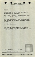
|reason_nsm=The area shown on the accompanying map includes the area mined for White Oak No. 2 Mine (mine index [[3625]]). The boundary between the two mines could not be discerned. According to the source maps, Oak Ridge Mine (White Oak No. 2 Mine) was generally north of the railroad, while White Oak No. 1 Mine was generally south of the railroad. With the area mined before reported production, production indicates approximately 320 acres were mined. | |||
|Mine-index=3627 | |Mine-index=3627 | ||
|Coal_co=Dishew | |Coal_co=Dishew | ||
|Mine Name Header=White Oak No. 1 Mine | |Mine Name Header=White Oak No. 1 Mine | ||
|mine_type=Underground | |mine_type=Underground | ||
|mined-out-area= | |mined-out-area=239 | ||
|indicated=No | |||
|county1=St. Clair | |county1=St. Clair | ||
|quad1=Tilden | |quad1=Tilden | ||
| Line 15: | Line 17: | ||
|Latitude=38.2279923190001 | |Latitude=38.2279923190001 | ||
|Longitude=-89.725729251 | |Longitude=-89.725729251 | ||
|Zoom= | |Zoom=15 | ||
}} | }} | ||
==Shaft, Slope, Drift or Tipple Location(s)== | ==Shaft, Slope, Drift or Tipple Location(s)== | ||
| Line 21: | Line 23: | ||
{{Shaft locations header}} | {{Shaft locations header}} | ||
{{Shaft locations | {{Shaft locations | ||
|shaft_type=Main shaft {{#info: No air shafts were shown on the source maps. It is likely that ventilation was provided by underground connection with White Oak No. 2 Mine (mine index 3625).|note}} | |shaft_type=Main shaft {{#info: No air shafts were shown on the source maps. It is likely that ventilation was provided by underground connection with White Oak No. 2 Mine (mine index [[3625]]).|note}} | ||
|County=St. Clair | |County=St. Clair | ||
|Town-Range=3S 6W | |Town-Range=3S 6W | ||
| Line 34: | Line 36: | ||
|depth=140 | |depth=140 | ||
|thick-ave=7.0-7.5 | |thick-ave=7.0-7.5 | ||
|mining-method=MRP | |||
}} | }} | ||
===Geological Problems Reported=== | ===Geological Problems Reported=== | ||
| Line 45: | Line 48: | ||
|Date=pre1881-1882 {{#info: Production, ownership, and years of operation before July 1882 are not known. The 1882 Coal Report indicated 26 acres were mined.|note}} | |Date=pre1881-1882 {{#info: Production, ownership, and years of operation before July 1882 are not known. The 1882 Coal Report indicated 26 acres were mined.|note}} | ||
|Production=30,000 | |Production=30,000 | ||
|Sum=No | |||
}} | }} | ||
{{Production | {{Production | ||
| Line 51: | Line 55: | ||
|Date=1882-1883 | |Date=1882-1883 | ||
|Production=30,000 | |Production=30,000 | ||
|Sum=No | |||
}} | |||
{{Production | |||
|Production=60,000 | |||
|Sum=Yes | |||
}} | }} | ||
===Production Notes=== | ===Production Notes=== | ||
| Line 59: | Line 68: | ||
{{Source map header}} | {{Source map header}} | ||
{{Source Map | {{Source Map | ||
|Source Map= | |Source Map=State archive, IL_122_01 | ||
|Map Date=8-27-1920 | |Map Date=8-27-1920 | ||
|Original Scale=1:2400 | |Original Scale=1:2400 | ||
|Digitized Scale=1: | |Digitized Scale=1:2400 | ||
|Map Type=Final | |Map Type=Final | ||
}} | }} | ||
| Line 83: | Line 92: | ||
}} | }} | ||
{{Annotated bibliography | {{Annotated bibliography | ||
|bibliography= | |bibliography=State archive, IL_122_01 - Shaft location, mine outline, mining method. | ||
}} | }} | ||
{{Annotated bibliography | {{Annotated bibliography | ||
Latest revision as of 15:32, January 24, 2024
Mine Index Number: 3627
| Company Name: | Dishew | ||
|---|---|---|---|
| Mine Name: | White Oak No. 1 Mine | ||
| Start Date: | Unknown | End Date: | 1883 |
| Type of Mine: | Underground | ||
| Total acres shown: | 239 | ||
| Acres after map date: | General Area of mining acres shown: | ||
|
The area shown on the accompanying map includes the area mined for White Oak No. 2 Mine (mine index 3625). The boundary between the two mines could not be discerned. According to the source maps, Oak Ridge Mine (White Oak No. 2 Mine) was generally north of the railroad, while White Oak No. 1 Mine was generally south of the railroad. With the area mined before reported production, production indicates approximately 320 acres were mined. | |||
Shaft, Slope, Drift or Tipple Location(s)
| Type | County | Township-Range | Section | Part Section |
|---|
| Main shaft No air shafts were shown on the source maps. It is likely that ventilation was provided by underground connection with White Oak No. 2 Mine (mine index 3625). | St. Clair | 3S 6W | 35 | SE NE NW |
Geology
| Thickness (ft) | |||||
|---|---|---|---|---|---|
| Seam | Depth (ft) | Min | Max | Ave | Mining Method |
| Herrin | 140 | 7.0-7.5 | MRP |
Geological Problems Reported
Production
| Company | Mine Name | Date | Production (tons) |
| Donk and Tizon | White Oak No. 1 | pre1881-1882 Production, ownership, and years of operation before July 1882 are not known. The 1882 Coal Report indicated 26 acres were mined. | 30,000 |
| Dishew | White Oak No. 1 | 1882-1883 | 30,000 |
| Total Production: 60,000 | |||
Production Notes
Coal Report production (if available)
Sources of Data
| Source Map | Map Date | Original Scale | Digitized Scale | Map Type |
| State archive, IL_122_01 | 8-27-1920 | 1:2400 | 1:2400 | Final |
| Microfilm, document 351006 | 12-30-1885 | 1:1200 | 1:1075 | Not final |
Annotated Bibliography (Data source - brief description of information)
| Coal Reports - Production, ownership, years of operation, mine type, seam, depth, thickness. |
| Directory of Illinois Coal Mines (St. Clair County) - Mine names, mine index, ownership, years of operation. |
| Mine notes (St. Clair County) - Shaft location. |
| State archive, IL_122_01 - Shaft location, mine outline, mining method. |
| Microfilm map, document 351006, reel 03134, frame 76 - Shaft identification. |
Mine Notes
Mine Images
![[[:Meeks No. 2|Meeks No. 2]]](https://wikiimage.isgs.illinois.edu/ilmines/st_clair/thumbnails/m0205_IL_122_01_th.jpg)
![[[:White Oak No. 2|White Oak No. 2]]](https://wikiimage.isgs.illinois.edu/ilmines/st_clair/thumbnails/m3625.jpg)
Photographs