|
|
| Line 1: |
Line 1: |
| {{Sidebar Info Query}} | | {{Sidebar Info Query}} |
| {{Header | | {{Header |
| |checked=1st Entry | | |checked=Checked OK |
| |unlocated=No | | |unlocated=No |
| |shown_on_map=Yes | | |shown_on_map=Yes |
| Line 9: |
Line 9: |
| |mine_type=Surface | | |mine_type=Surface |
| |mined-out-area=674 | | |mined-out-area=674 |
| | |indicated=No |
| |county1=St. Clair | | |county1=St. Clair |
| |quad1=French Village | | |quad1=French Village |
Revision as of 14:14, September 24, 2022
Mine Index Number: 3589
| Company Name:
|
F. C. Morgan Coal Company
|
| Mine Name:
|
Morgan Mine
|
| Start Date:
|
1933
|
End Date:
|
1961
|
| Type of Mine:
|
Surface
|
| Total acres shown:
|
674
|
| Acres after map date:
|
|
General Area of mining acres shown:
|
|
|
|
Shaft, Slope, Drift or Tipple Location(s)
| Type
|
County
|
Township-Range
|
Section
|
Part Section
|
| Main tipple
|
St. Clair
|
1S 9W
|
10
|
SE SW SW
|
Geology
| Herrin
|
38-50
|
5.0
|
7.0
|
6.0
|
Surface
|
Geological Problems Reported
Production
| Company
|
Mine Name
|
Date
|
Production (tons)
|
| F. C. Morgan Coal Company
|
Morgan
|
1933-1961
|
4,762,825 Yearly production figures were collected from the tipple, not individual pits. Evidence indicates that most pits were mined for 1 or 2 years and then new pits were opened elsewhere. As production cannot be tied to a location, the company's total production and total area mined are shown here. Most of these pits are near Millstadt and included on the Millstadt quadrangle.
|
| Total Production: 4,762,825 Yearly production figures were collected from the tipple, not individual pits. Evidence indicates that most pits were mined for 1 or 2 years and then new pits were opened elsewhere. As production cannot be tied to a location, the company's total production and total area mined are shown here. Most of these pits are near Millstadt and included on the Millstadt quadrangle.
|
Production Notes
Coal Report production (if available)
Sources of Data
| Company, 6-271
|
6-1959
|
1:42240
|
1:42240
|
Final
|
| Microfilm, document 351165
|
6-2-1954
|
1:2400
|
1:1986
|
Not final
|
| Microfilm, document 351169
|
5-8-1952
|
1:1200
|
1:1324
|
Final
|
| Microfilm, document 351170
|
5-8-1952
|
1:1200
|
1:1200
|
Final
|
| Microfilm, document 351171
|
4-7-1953
|
1:2400
|
1:2152
|
Not final
|
| Microfilm, document 351172
|
4-8-1953
|
1:1200
|
1:1200
|
Not final
|
| Microfilm, document 350982
|
5-9-1950
|
1:2400
|
1:2400
|
Final
|
| Company, 6-271
|
7-1959
|
1:42240
|
1:42240
|
Not final
|
| Company, 6-271 (tracing)
|
Undated
|
1:12068
|
1:12068
|
Undated
|
| ISGS mined-out area compilation
|
1950
|
1:62500
|
1:62500
|
Secondary source
|
Annotated Bibliography (Data source - brief description of information)
| Coal Reports - Production, ownership, years of operation, method.
|
| Directory of Illinois Coal Mines (St. Clair County) - Mine names, mine index, ownership, years of operation.
|
| Company map, ISGS Coal Section files - Pit outlines, method.
|
| Mine notes (St. Clair County) - Thickness, depth, seam, mine type.
|
| Company map, ISGS Coal Section files - Mine outline, mining method.
|
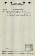
| Microfilm map, document 351165, reel 03134, frame 308 - Mine outline (pit, SE SE 12-T1S-R9W).
|
| Microfilm map, document 351169, reel 03134, frame 315 - Mine outline (SE NE 27-T1S-R9W; final, worked out 9- 1951).
|
| Microfilm map, document 351170, reel 03134, frame 316 - Mine outline (NE 22-T1S-R9W; final, worked out 11-1951).
|
| Microfilm map, document 351171, reel 03134, frame 317 - Mine outline (N ½ NE 18-T1S-R8W).
|
| Microfilm map, document 351172, reel 03134, frame 318 - Mine outline (SW 10-T1S-R9W).
|
| Microfilm map, document 350982, reel 03134, frame 47 - Mine outline (SE 14-T1S-R9W & NE 22-T1S-R9W).
|
| Company map (sketches), Coal Section files, 6-271 - Mine outlines.
|
| ISGS mined-out area map, 1950 - Mine outlines: NW 34-T1N-R9W
|
Mine Notes
Mine Images
Company map: 6-271
Map Date: 7-1-1959
Coal Co.: F. C. Morgan Coal Company
Mine Name: Morgan Mines
Full Res Download
Coal Section Files: 6-271
Map Date: Undated
Coal Co.: F. C. Morgan Coal Company
Mine Name: Morgan Mines
Company map: 6-271
Map Date: 7-1-1959
Coal Co.: F. C. Morgan Coal Company
Mine Name: Morgan Mines
Company map: 6-271
Map Date: 7-1-1959
Coal Co.: F. C. Morgan Coal Company
Mine Name: Morgan Mines
Microfilm: 351165
Map Date: 6-2-1954
Coal Co.: F. C. Morgan Coal Company
Mine Name: Morgan Mines
Microfilm: 351169
Map Date: 5-8-1952
Coal Co.: F. C. Morgan Coal Company
Mine Name: Morgan Mines
Microfilm: 351170
Map Date: 5-19-1952
Coal Co.: F. C. Morgan Coal Company
Mine Name: Morgan Mines
Microfilm: 351171
Map Date: 4-7-1953
Coal Co.: F. C. Morgan Coal Company
Mine Name: Morgan Mines
Microfilm: 350982
Map Date: 5-16-1950
Coal Co.: F. C. Morgan Coal Company
Mine Name: Morgan Mines
Microfilm: 350982
Map Date: 5-16-1950
Coal Co.: F. C. Morgan Coal Company
Mine Name: Morgan Mines
Coal Section Files: Area 27
Map Date: 1950
Coal Co.: F. C. Morgan Coal Company
Mine Name: Morgan Mines
![[[:Morgan|Morgan]]](https://wikiimage.isgs.illinois.edu/ilmines/st_clair/thumbnails/m3589_351172_th.jpg) These files may not be true to scale and are not georgistered. These files may not be true to scale and are not georgistered.
|
Map Type:
|
Microfilm
|
| Map ID:
|
351172 3134 318
|
| Company:
|
Morgan Coal Company
|
| Mine Name:
|
Morgan
|
| Caption:
|
|
| Map Date:
|
05-04-1953
|
| Map Status:
|
Not Final
|
| Image Credit:
|
|
| Note:
|
|
| More Info:
|
M3589 351172
|
| Full Res Download:These files are true to scale and most are georegistered for gis software. These files may be a very large (>1GB) download!
|
https://wikiimage.isgs.illinois.edu/ilmines/st clair/m3589 351172.zip
|
Photographs