4316: Difference between revisions
No edit summary |
No edit summary |
||
| Line 1: | Line 1: | ||
{{Sidebar Info Query}} | {{Sidebar Info Query}} | ||
{{Header | {{Header | ||
|checked= | |checked=Checked OK | ||
|unlocated=No | |unlocated=No | ||
|shown_on_map=Yes | |shown_on_map=Yes | ||
| Line 8: | Line 8: | ||
|Mine Name Header=Hickory Mine | |Mine Name Header=Hickory Mine | ||
|mine_type=Underground | |mine_type=Underground | ||
|mined-out-area=3 | |mined-out-area=3 | ||
|after_map=Less than 1 | |||
|indicated=No | |||
|county1=St. Clair | |county1=St. Clair | ||
|quad1=French Village | |quad1=French Village | ||
| Line 83: | Line 85: | ||
{{Annotated bibliography | {{Annotated bibliography | ||
|bibliography=Directory of Illinois Coal Mines (St. Clair County) - Mine names, mine index, ownership, years of operation. | |bibliography=Directory of Illinois Coal Mines (St. Clair County) - Mine names, mine index, ownership, years of operation. | ||
}} | }} | ||
{{Annotated bibliography | {{Annotated bibliography | ||
Revision as of 22:45, September 28, 2022
Mine Index Number: 4316
| Company Name: | Hickory Coal Mining Company | ||
|---|---|---|---|
| Mine Name: | Hickory Mine | ||
| Start Date: | 1924 | End Date: | 1928 |
| Type of Mine: | Underground | ||
| Total acres shown: | 3 | ||
| Acres after map date: | Less than 1 | General Area of mining acres shown: | |
Shaft, Slope, Drift or Tipple Location(s)
| Type | County | Township-Range | Section | Part Section |
|---|
| Drift | St. Clair | 1N 9W | 3 | NW NE NW |
Geology
| Thickness (ft) | |||||
|---|---|---|---|---|---|
| Seam | Depth (ft) | Min | Max | Ave | Mining Method |
| Herrin | 6.5 | RPB |
Geological Problems Reported
Production
| Company | Mine Name | Date | Production (tons) |
| Hickory Coal Mining Company | Hickory | 1924-1927 | 8,223 |
| Hickory Coal Mining Company | Hickory | 1927-1928 | 3,378 Production since map date |
| Total Production: 11,601 | |||
Production Notes
Coal Report production (if available)
Sources of Data
| Source Map | Map Date | Original Scale | Digitized Scale | Map Type |
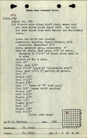
| Microfilm, document 351133 | 3-4-1927 | 1:1200 | 1:1821 | Not final |
| ISGS field notes (H. R. Wanless) | 8-14-1931 | 1:62500 | 1:62500 | Secondary source |
Annotated Bibliography (Data source - brief description of information)
| Coal Reports - Production, ownership, years of operation. |
| Directory of Illinois Coal Mines (St. Clair County) - Mine names, mine index, ownership, years of operation. |
| Microfilm map, document 351133, reel 03134, frame 269 - Mine outline, geologic problems, method. |
| ISGS field notes (St. Clair County) - Mine type, drift location, thickness. |
Mine Notes
Mine Images

Photographs