6639: Difference between revisions
No edit summary |
No edit summary |
||
| Line 1: | Line 1: | ||
{{Sidebar Info Query}} | {{Sidebar Info Query}} | ||
{{Header | {{Header | ||
|checked= | |checked=Checked OK | ||
|unlocated=No | |unlocated=No | ||
|shown_on_map=Yes | |shown_on_map=Yes | ||
|reason_nsm=Most of the area shown was mined prior to production reports. | |||
|Mine-index=6639 | |Mine-index=6639 | ||
|Coal_co=Standard Coal Company | |Coal_co=Standard Coal Company | ||
| Line 9: | Line 10: | ||
|mine_type=Underground | |mine_type=Underground | ||
|mined-out-area=27 | |mined-out-area=27 | ||
|after_map=2 | |after_map=Less than 2 | ||
|indicated=Yes | |||
|county1=St. Clair | |county1=St. Clair | ||
|quad1=French Village | |quad1=French Village | ||
Revision as of 23:12, September 28, 2022
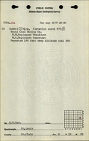
Mine Index Number: 6639
| Company Name: | Standard Coal Company | ||
|---|---|---|---|
| Mine Name: | Summit Mine | ||
| Start Date: | 1865 | End Date: | 1886 |
| Type of Mine: | Underground | ||
| Total acres shown: | 27 | ||
| Production Indicated Acres: | Less than 2 | General Area of mining acres shown: | |
|
Most of the area shown was mined prior to production reports. | |||
Shaft, Slope, Drift or Tipple Location(s)
| Type | County | Township-Range | Section | Part Section |
|---|
| Main shaft | St. Clair | 1N 9W | 11 | NW SE NE |
| Air shaft | St. Clair | 1N 9W | 11 | SW NE NE |
Geology
| Thickness (ft) | |||||
|---|---|---|---|---|---|
| Seam | Depth (ft) | Min | Max | Ave | Mining Method |
| Herrin | 175 | 5.0-6.0 | RPB |
Geological Problems Reported
Production
| Company | Mine Name | Date | Production (tons) |
| Summit Mining Company | Summit | 1865-1884 | 14,347 Production prior to 1884 unknown |
| Standard Coal Company | Summit | 1884-1885 | 18,653 |
| Standard Coal Company | Summit | 1885-1886 | 8,500 Production after map date |
| Total Production: 41,500 | |||
Production Notes
Coal Report production (if available)
Sources of Data
| Source Map | Map Date | Original Scale | Digitized Scale | Map Type |
| Microfilm, document 351017 | 11-5-1885 | 1:1200 | 1:1821 | Not final |
| State archive, PB_96 | 9-15-1923 | 1:2400 | 1:2400 | Secondary source |
Annotated Bibliography (Data source - brief description of information)
| Coal Reports - Production, ownership, years of operation. |
| Directory of Illinois Coal Mines (St. Clair County) - Mine names, mine index, ownership, years of operation. |
| Mine notes (St. Clair County) - Thickness, depth, seam, mine type, shaft locations. |
| Microfilm map, document 351017, reel 03134, frame 92 - Shaft locations, mine outline, mining method. |
| State archive, PB_96, map of Superior Mine (mine index 78) - Mine outline (northern portion). |
Mine Notes

Mine Images


Photographs