Category:Winchester-Quadrangle
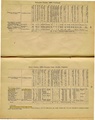
County Coal Data
Mines that Appear in Winchester-Quadrangle
*9998 & 9999 = Unknown dates
Unlocated Mines in Winchester-Quadrangle
Mine that have known coal production but no known location
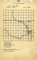
Historical Mined Out Area Maps
WPA
These maps were constructed as part of the nationwide Works Projects Administration (WPA), generally between 1934 and 1937 with some later updates or revisions,
Disclaimer
Maps for some locations might have multiple versions/seams, please inspected these areas closely for differences.
Notes and corrections were made by ISGS staff.
These maps are reproductions from microfilm, they may be of poor quality with text difficult to read.
There are no Quade Maps for this county
Federal Land Bank of St. Louis, Preliminary Reports on Subsidence Investigations
Federal Land Bank of St. Louis, Preliminary Reports on Subsidence Investigations (refered by Coal Section Staff as "Quade Maps")
Mining engineers working for the Federal Land Bank of St. Louis mapped areas of subsidence due to coal mining in the early 1930s. These reports often include county maps of mine properties with mined-out areas including shaft locations, as well as subsidence areas.
Disclaimer
Maps for some locations might have multiple versions/seams, please inspected these areas closely for differences.
These maps are accompanied by a report, please download and inspect this document.
Notes and corrections were made by ISGS staff.
There are no Quade Maps for this county
Photographs
Pages in category "Winchester-Quadrangle"
The following 83 pages are in this category, out of 83 total.
2
4
5
9
- 91710317
- 91712860
- 91713041
- 91713741
- 91715187a
- 91715187c
- 91715950
- 91716152a
- 91716152b
- 91716152c
- 91716676
- 91716678
- 91716680
- 91716681
- 91716682
- 91716683
- 91716685
- 91716686
- 91716688
- 91716689
- 91716691a
- 91716691b
- 91716694a
- 91716694b
- 91716694c
- 91716695a
- 91716695b
- 91716695c
- 91716696b
- 91716697
- 91716698
- 91716699
- 91716700a
- 91716700b
- 91716702
- 91716704
- 91716705a
- 91716705b
- 91716706
- 91716709
- 91716710
- 91716715
- 91716716
- 91716717
- 91716720
- 91716722a
- 91716726
- 91716727a
- 91716727b
- 91716727c
- 91716728
- 91716729
- 91716730a
- 91716730b
- 91716732
- 91716735
- 91716736
- 91716737
- 91716738
Media in category "Winchester-Quadrangle"
The following 27 files are in this category, out of 27 total.
 M0317 minenotes.pdf 727 × 1,166, 3 pages; 2.21 MB
 M2300 coalreport1883.pdf 1,260 × 1,587; 696 KB
 M3444 fieldnotes.pdf 758 × 1,191; 173 KB
 M3444 minenotes.pdf 727 × 1,166, 6 pages; 6.07 MB
 M3445 coalreport1884.pdf 1,581 × 1,266; 335 KB
 M3445 coalreport1885.pdf 602 × 975, 2 pages; 160 KB
 M3446 minenotes.pdf 727 × 1,166; 880 KB
 M3448 minenotes.pdf 727 × 1,166; 880 KB
 M4978 coalreport1883.pdf 1,260 × 1,587; 690 KB
 M5294 coalreport1883.pdf 1,260 × 1,587; 699 KB
 M6694 coalreport1883.pdf 1,260 × 1,587; 690 KB
 M6695 coalreport1883.pdf 1,260 × 1,587; 696 KB
 M6722 fieldnotes.pdf 752 × 1,185, 2 pages; 389 KB
 M6723 fieldnotes.pdf 752 × 1,187; 180 KB
 M6734 fieldnotes.pdf 758 × 1,191; 3.43 MB
 M6734 minenotes.pdf 727 × 1,166; 1.27 MB
 M6739 fieldnotes.pdf 752 × 1,185; 207 KB
 M7752 fieldnotes.pdf 752 × 1,187, 3 pages; 5.08 MB
 M7753 fieldnotes.pdf 756 × 1,189, 2 pages; 352 KB
 M7758 fieldnotes.pdf 754 × 1,185, 3 pages; 488 KB
 M7759 fieldnotes.pdf 750 × 1,185; 229 KB
 M7760 fieldnotes.pdf 752 × 1,187; 170 KB
 M7761 fieldnotes.pdf 752 × 1,185; 193 KB
 M7762 fieldnotes.pdf 745 × 1,193, 2 pages; 350 KB
 M7763 fieldnotes.pdf 752 × 1,185; 161 KB
 M7778 Worthen Vol III.pdf 1,275 × 1,650; 228 KB
 M7779 Worthen Vol III.pdf 1,275 × 1,650; 225 KB