Mine Index Number: 6734
| Company Name:
|
George E. Berry
|
| Mine Name:
|
Berry Mine
|
| Start Date:
|
1934
|
End Date:
|
1936
|
| Type of Mine:
|
Underground
|
| Total acres shown:
|
None
|
| Acres after map date:
|
1
|
General Area of mining acres shown:
|
|
|
|
Shaft, Slope, Drift or Tipple Location(s)
| Type
|
County
|
Township-Range
|
Section
|
Part Section
|
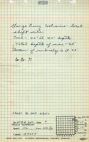
| Main shaft
|
Scott
|
15N 12W
|
30
|
SE NE NE
|
Geology
| Colchester
|
20
|
|
|
2.5
|
Underground
|
Geological Problems Reported
Production
| Company
|
Mine Name
|
Date
|
Production (tons)
|
Production Notes
Coal Report production (if available)
Sources of Data
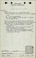
| ISGS field notes (E. T. Benson)
|
circa 1935
|
1:62500
|
1:62500
|
Secondary source
|
Annotated Bibliography (Data source - brief description of information)
| Coal Reports - Production, ownership, years of operation.
|
| Directory of Illinois Coal Mines (Scott County) - Mine names, mine index, ownership, years of operation, seam.
|
| Mine notes (Scott County) - Mine type, shaft location, depth, thickness.
|
| ISGS field notes (Scott County) - Mine type, shaft location, depth, thickness.
|
Mine Notes
Mine Images
Photographs