Mine Index Number: 4538
| Company Name:
|
Unknown
|
| Mine Name:
|
Unknown Mine
|
| Start Date:
|
Before 1923
|
End Date:
|
Unknown
|
| Type of Mine:
|
Unknown
|
| Total acres shown:
|
|
| Acres after map date:
|
|
General Area of mining acres shown:
|
|
|
|
Shaft, Slope, Drift or Tipple Location(s)
| Type
|
County
|
Township-Range
|
Section
|
Part Section
|
| Main shaft
|
Macoupin
|
7N 9W
|
35
|
SE SE NE
|
Geology
| Herrin
|
70-80
|
4.0
|
7.0
|
4.5
|
Underground
|
Geological Problems Reported
Production
| Company
|
Mine Name
|
Date
|
Production (tons)
|
Production Notes
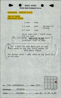
The ISGS field notes mention Lewis Lucking and Ed Lucking in conjunction with this mine. This location may be related to the unlocated production for Lucking/Lueking (mine index 91170016).
Coal Report production (if available)
Sources of Data
| ISGS field notes (D. M. Collingwood)
|
1923
|
(text only)
|
1:24000 Point plotted onto 1:24,000 USGS topographic map and digitized.
|
Secondary source
|
Annotated Bibliography (Data source - brief description of information)
| Directory of Illinois Coal Mines (Macoupin County) - Mine location.
|
| ISGS field notes (Macoupin County) - Mine type, shaft location, seam, depth, thickness.
|
Mine Notes
Mine Images
 These files may not be true to scale and are not georgistered. These files may not be true to scale and are not georgistered.
|
Map Type:
|
USGS topographic
|
| Map ID:
|
USGS topographic Coal Section files
|
| Company:
|
|
| Mine Name:
|
|
| Caption:
|
|
| Map Date:
|
1928
|
| Map Status:
|
Secondary
|
| Image Credit:
|
|
| Note:
|
Notes made by unknown coal section staff on the Brighton Quadrangle 1928 edition.
|
| More Info:
|
Brighton topo 1928
|
| Full Res Download:These files are true to scale and most are georegistered for gis software. These files may be a very large (>1GB) download!
|
https://go.illinois.edu/ILMImages/macoupin/brighton topo 1928.zip
|
Photographs