Mine Index Number: 1004
| Company Name:
|
Illinois Fuel Company, LLC
|
| Mine Name:
|
I-1 Surface Mine
|
| Start Date:
|
1982
|
End Date:
|
2001
|
| Type of Mine:
|
Surface
|
| Total acres shown:
|
1,066Production indicates approximately 200 acres or more were mined after the map date in Saline County.
|
| Acres after map date:
|
200
|
General Area of mining acres shown:
|
|
|
|
Shaft, Slope, Drift or Tipple Location(s)
| Type
|
County
|
Township-Range
|
Section
|
Part Section
|
| Pit
|
Gallatin
|
10S 8E
|
16,17,18,19
|
|
| Pit
|
Saline
|
10S 7E
|
11,13,14,23,24
|
|
Geology
| Herrin
|
140
|
|
|
3.0-4.0
|
Surface
|
| Davis
|
125-130These depths were not measured at the same location, but in the locations where each coal was present and thick enough to mine.
|
|
|
4.0
|
Surface
|
Geological Problems Reported
Production
| Company
|
Mine Name
|
Date
|
Production (tons)
|
Production Notes
Coal Report production (if available)
Sources of Data
| Company (digital)
|
1-2012
|
1:2400
|
1:2400
|
Not finalThe outline shown is of affected acres, which may not reflect actual mining.
|
| Company (digital)
|
1-1-2001
|
1:24000
|
1:24000
|
Final, not finalFinal for Gallatin County pits, not final for Saline County pits
|
| Company (paper)
|
1-1-2001
|
1:4896
|
1:4896
|
FinalThis map is final for the areas shown.
|
| Company (paper)
|
1-10-2000
|
1:4800
|
1:4800
|
FinalThis map is final for the areas shown.
|
| Company (paper), 1-42-27
|
4-18-1994
|
1:4800
|
1:4800
|
FinalThis map is final for the areas shown.
|
| Company (paper)
|
12-31-1994
|
1:4800
|
1:4800
|
FinalThis map is final for the areas shown.
|
| NAIP digital ortho-photo quadrangle
|
2015
|
1:6000
|
1:6000
|
Secondary source
|
Annotated Bibliography (Data source - brief description of information)
| Coal Reports - Production, ownership, years of operation, depth.
|
| Mine notes (Gallatin County) - Mine type, mine location, seam, thickness, mining method, geologic problems.
|
| Company map, Coal Section files (digital) - Mine outline, mining method.
|
| Company map, Coal Section files, not numbered and 1-42-27 - Mine outline, mining method.
|
| National Agriculture Imagery Program map, digital ortho-photo quadrangle map - Mine outline.
|
Mine Notes
Mine Images
Photographs
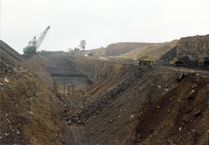
Caption: Jader Fuel Co. mine, looking south. Springfield Coal on floor of pit below dragline dips north, toward camera. On bench at west (right), Briar Hill Coal is being loaded. Herrin Coal is being uncovered farther to the west, out of the picture.
Date: 08/27/1986


