Circular 530 Channels
| Geologic Disturbances in Illinois Coal Seams | ||||||||||
|---|---|---|---|---|---|---|---|---|---|---|
| Channels | Split Coal | Rolls | Limestone Bosses | Clay Dikes | White Top | Igneous Dikes | Joints | Coal Balls | Miscellaneous Disturbances | Acknowledgments |
Channels
A channel is the course of an ancient river that eroded part or all of a coal seam and/or the adjacent layers of rock. Because channels are widespread in the Illinois Basin Coal Field, many have serious effects on coal mining. (Contemporary river channels, which are easy to identify and avoid, cause no serious problems.) Miners call ancient river channels by various names: washouts and cutouts are commonly used when the same has been completely eroded.
In Illinois, coal mining is affected by channels formed during two geologic periods: (1) the Pleistocene Epoch, beginning about 2 million years ago, when this region was invaded repeatedly by glaciers; and (2) the Pennsylvanian Period, 315 to 280 million years ago, when layers of coal-forming peat accumulated in vast tropical swamps. Some Pennsylvanian channels already existed as the peat was, accumulating, while others developed later as sediment-covered peat beds became eroded.
Pleistocene Channels
For this report, Pleistocene channels are defined as valleys or watercourses filled with materials deposited during the Pleistocene Epoch. Although geologists dispute the ages of various channels, some of these channels were probably cut before the first advance of glacial ice over Illinois (Willman and Frye, 1970).
Four major stages of Pleistocene glaciation (ice ages) left their record in Illinois. At one time or another, glaciers covered nearly all the land now underlain by coal. They blocked and altered the courses of rivers, including the precursors of the Mississippi, Ohio, and Illinois Rivers. During the warm interglacial stages, they left thick deposits of clay, sand, gravel, and boulders to fill valleys and profound change the topography. Great torrents of meltwater scoured valleys and cut through older deposits into bedrock. When the ice returned, these valleys were buried again.
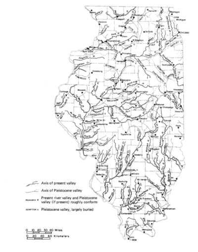
Consequently, many Pleistocene channels are completely buried, have little or no relationship to present drainage patterns (fig. I), and can be detected only by drilling or by other subsurface exploration. One of the largest and most important buried channels is the Mahomet Bedrock Valley. Created by the ancient Teays River, this channel originated in West Virginia, crossed Ohio and Indiana, and entered Illinois just north of Danville. The virtually level farmland north of Champaign and Danville gives no clue to the presence of this buried valley, which is several miles wide and more than 400 feet deep (Piskin and Bergstrom, 1975).
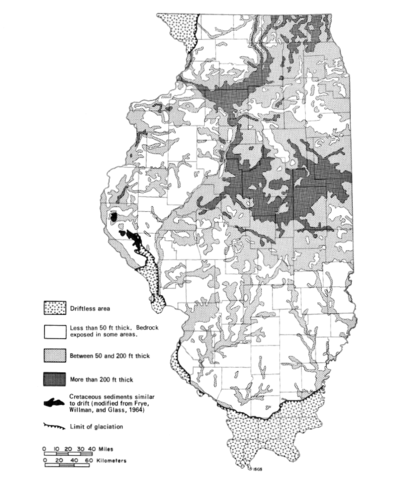
A variety of unconsolidated deposits, known collectively as glacial drift, fill Pleistocene channels. Many channels contain a type of drift called outwash, a well-sorted sand and gravel left by meltwater rivers. Outwash is highly permeable and may yield large quantities of groundwater. In fact, the thick sand and gravel deposits in the Mahomet Bedrock Valley are an important source of groundwater for central Illinois. Not all subsurface deposits commonly found in Pleistocene channels transmit or store water so readily. Fine-grained deposits from glacial lakes and sluggish streams are less permeable. The poorly sorted mixtures of clay, sand, gravel, and boulders, which are called till, also supply little groundwater. Figure 2 shows the generalized thickness of glacial drift in Illinois. Additional details on the thickness and nature of glacial drift are presented by Willman and Frye (1970) and Piskin and Bergstrom (1975).
Underground mining problems.
A Pleistocene channel is a hazard to underground mining. Not only do such channels hold large amounts of groundwater, but they also contain loose materials that are nearly impossible to support in the roof. Many fatalities in the early history of mining, including the drowning of 69 men in the Diamond Mine disaster of 1883, resulted from mining too closely under water-saturated deposits of sand and gravel. If such a channel is penetrated in mining, or undermined and exposed in a roof fall, the sand and gravel as well as the water could rush into the mine. Fortunately, such dangers can be avoided by subsurface exploration before mining. Careful logging of test holes is critical in areas of shallow underground mines so that the extent of Pleistocene channels can be assessed accurately.
Penetrating channels is not the only danger involved in shallow underground mining in areas of buried Pleistocene valleys. Roof failure, rib rashing, and squeezes occur more often under buried valleys than elsewhere. The shallower the mine and the greater the relief on the bedrock surface, the more severe the problems. In mountainous regions, such as West Virginia, the roofs of mines are frequently unstable under stream valleys. Here in Illinois, three documented cases of floor failure leading to squeezes and subsidence were related to mining under Pleistocene channels. In all three situations, the valleys were deeper than 100 feet, and the glacial drift was thicker than the bedrock above the coal (Hunt, Bauer, and DuMontelle, 1982).
Engineering studies based on computer modeling indicate that compressive stresses on pillars and roof corners (junctions of roof and rib) and tensile stresses on midspans of entries are higher under valleys than under hills (Wang, Ropchan, and Sun, 1974). Compression on pillars can produce rib rashing and squeezes, while tension on the midspan promotes roof failure. Ferguson (1967) states that rock under valleys is weakened by microfracturing invisible to the naked eye; such microfracturing is produced when the valleys are eroded and overburden pressures are relieved, allowing the rock to rebound into the valley. Mechanical testing of core samples a t the Illinois State Geological Survey reveals that shales beneath buried valleys are up to 25 percent weaker than the same shales away from valleys (R. A. Bauer, personal communication,1982).
Surface mining problems.
A few years ago, a surface mine was abandoned in Jackson County because of channels. The coal seam was not eroded, but the channels contained water-saturated sand that flowed like quicksand into the pits. In turn, movement of the sand triggered large-scale slumping of overlying till into the excavations. Water, sand, and till filled the pits faster than they could be removed. Channels at this site were as much as 50 feet deep, but only a few hundred feet wide. To accurately map channels with such dimensions, closely spaced drilling is necessary.
Pleistocene channels filled with sand and gravel may serve as sources of groundwater for homes, farms, and villages. Mining through such aquifers may deplete or pollute supplies. The risks must be considered in the planning of surface mines.
Pennsylvanian Channels
Many large river systems existed during the Pennsylvanian Period; some prevent peat from accumulating and some eroded existing peat beds. Three well known channel systems have profound effects on coal mining on Illinois:
- Anvil Rock Sandstone and younger sandstone fill channels that interrupt the Herrin (No. 6) Coal Member. These channels cut through the Herrin peat after it was covered with sediments.
- The Walshville channel was the course of a major river existing during and following accumulation of the Herrin peat.
- The Galatia channel was the course of a major stream coexisting with the peat that became the Springfield (No. 5) Coal Member.
Channels affecting coal seams other than the Herrin and Springfield are known in less detain and will be discussed last.
Channels of Anvil Rock Sandstone and younger sandstones
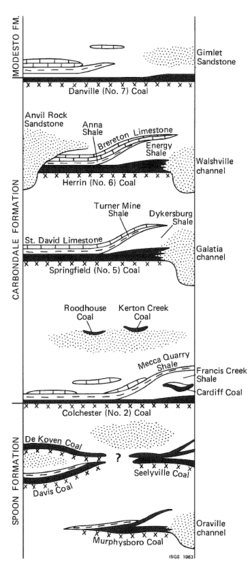
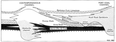
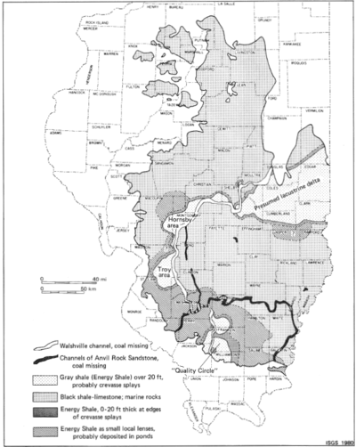
The Anvil Rock Sandstone Member is a rock unit that occurs above the Herrin (No. 6) Coal Member (figs. 3 and 4). In some parts of Illinois, however, the Anvil Rock Sandstone fills channels eroded into or completely through the Herrin Coal (fig. 5).
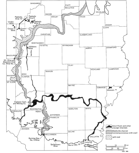
The largest channel meanders across southern Illinois from Gallatin to Randolph County (fig. 5). The Herrin Coal was eroded by this stream along a belt that ranged from slightly less than 1 mile to more than 4 miles wide. In some places, coal seams as deep as the Colchester (No. 2) Coal, 200 feet below the Herrin Coal, have also been cut out. Sandstone and siltstone mainly fill the channel, with some conglomerate near the base. The channel-fill deposits average 122 feet thick, and in some places, exceed 200 feet (Hopkins, 1958). Electric logs of oil-test holes have provided most of the data for this channel. Only one underground mine, the Clarkson Coal and Mining Company at Nashville (abandoned in 1940), mined up to its edge. No geologic details were available from this mine; nor was information obtained from a reported exposure of the channel at a surface mine in Randolph County. Only the closely spaced drill holes along the channel show the steep walls or banks where coal has been abruptly cut out and replaced by sandstone or siltstone.
Smaller channels filled with Anvil Rock Sandstone have been identified in several areas of Illinois. Active and abandoned underground mines in Christian, Macoupin, Montgomery, and Sangamon Counties provide the best documented examples (fig. 5). Most are a few hundred feet wide and at least several miles long. They show no preferred direction; some are nearly straight, but others branch and curve. In some channels, sandstone has completely replaced the Herrin (No. 6) Coal. In others, the sandstone or other channel-fill rocks form the immediate roof of a partly eroded coal seam. Still other channels eroded no coal at all, but scoured away the normal roof of black shale and limestone. Channels that incompletely eroded the coal or that only eroded and replaced roof strata are well documented (Simon, 1956; Potter and Mast,1963; DeMaris et al., 1979; Nelson and Nance, 1980).
A recent, detailed study shows that some channels, previously mapped as Anvil Rock, are actually filled with deposits younger than this sandstone. In central Illinois, for example, the Herrin (No. 6) Coal is completely eroded in two long, narrow, north-south trending channels. The first is in eastern Montgomery County where drill holes show a channel fill of sandstone younger than the Anvil Rock-probably the Gimlet Sandstone Member of the Modesto Formation (fig. 5); this channel is 200 to 300 feet wide and at least 6 miles long. To the west, a longer and wider cutout extends through Montgomery, Bond, Clinton, and Washington Counties; it is 1000 to 2000 feet wide and nearly straight to slightly curving. Either Anvil Rock or Gimlet Sandstone fills it. Both of these channels were encountered in now-abandoned underground mines; no geologic details on the channels are available.
No attempt was made to distinguish channel systems of different ages in figure 5. In some cases the evidence is incomplete. As to any effect on mining, the distinction is insignificant.
Mining problems.
Recently surface mines in Jackson, Williamson, and Gallatin Counties have exposed narrow channels of Anvil Rock Sandstone, locally replacing the Herrin (No. 6) Coal. Not enough information is available to map these cutouts away from the mines. In some cases, channel sandstone is porous and weakly cemented, so it conducts large amounts of water into the pits and slumps on the highwall. In other cases, the sandstone is hard and massive. To blast and remove it from the pit is difficult, especially for the small operator without a large dragline or stripping shovel. Furthermore, large blocks of sandstone may roll off the highwall without warning, crushing men and equipment below.
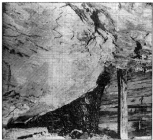
Underground mines present other problems (fig. 5); A southwest-trending channel about 500 feet wide completely cut out the coal at the abandoned Crown I Mine of Freeman Coal Mining Company in Montgomery County. It divided the mining property into two unequal parcels. To reach the coal northwest of the channel, Freeman had to drive sets of entries through solid rock. Mining in and near the channel was hazardous because of unstable, slickensided roof rock. Slickensides, which are common around the margins of many channels, apparently were formed by slippage as sand, peat, and mud compacted unevenly while turning into rock. At Crown 1 Mine, the coal was cut out sharply, but unevenly and at a low angle. The channel fill was mainly fine-grained sandstone, siltstone, and shale with some lenses of conglomerate (fig. 6).
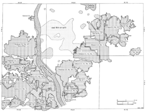
At another abandoned mine, the Peabody Mine No. 9 in Christian County, a complex branching system of Anvil Rock channels carved the Herrin Coal (Payne and Cady, 1940). Where the coal cut off at angles as great as 45 degrees, siltstone and silty shale replaced it (fig. 7). One set of entries driven across the channels encountered an island of coal completely surrounded by channel-fill rocks. Such a feature confirms that Anvil Rock channels occasionally changed their courses, as do many modern streams.
The most serious mining problem associated with these channels is wet working conditions. The Anvil Rock Sandstone frequently contains copious amounts of water, which flow or seep into the mine as the face advances. Since the seepage is likely to be dispersed over a wide area, gathering and pumping the water can be difficult. Dewatering or grouting the sandstone in advance may not be practical because this sandstone has low permeability. Also it may be divided into a series of separate, lens-shaped reservoirs (Nelson and Nance, 1980).
Roof stability under channel deposits varies greatly. Some sandstones are tightly cemented and make as solid a roof as limestone. Other sandstones and some sandy or silty shales are brittle, thinly laminated, and very difficult to support. Where sandstone overlies shale in the roof, the shale separates easily from the irregular, often slickensided base of the sandstone.
The Walshville Channel
An ancient river, as large as the present Mississippi River, flowed through the swamp where peat that became the Herrin (No. 6) Coal was accumulating. Its course became the Walshville channel (fig. 5), about 230 miles long and from 1 to more than 5 miles wide. This channel has been mapped continuously from its northern outcrop in Douglas County southwestward to its southern outcrop in Jackson County (Treworgy and Jacobson, in press). Probably, its source was in northern Michigan or in Canada, and its mouth was southwest of Illinois. Since no Pennsylvanian rocks exist today in these areas, we cannot be certain.
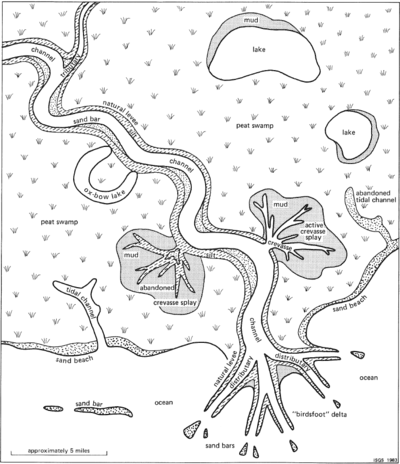
The Walshville channel contains no Herrin (No. 6) Coal-only shale, siltstone, sandstone, and conglomerate. The coal is missing, not because it was eroded, but because coal-forming peat did not accumulate in the riverbed. But as the Walshville changed its course many times, like the Mississippi and other modern streams, the former riverbeds or old channels filled with peat and other sediments. Some changes were gradual: the current undermined banks, carried away sediments, and deposited them downstream. Other changes were sudden: the river flooded, tore through its natural levees, and made new channels across the nearly flat alluvial plain. This happened most commonly where a river meander had developed into a broad loop. During a flood, the water cut across the narrow neck of the meander, shortening and straightening its course. The abandoned portion became an oxbow lake that gradually filled with sediments (fig. 8). For example, in western Franklin County the Walshville channel makes a complete loop, surrounding an "island" where the Herrin Coal is present. The eastern portion of this loop probably was the older course of the channel. The same process occurred during the flood of 1844 at Kaskaskia, Illinois. The Mississippi River cut a new, shorter course to the east, wiped out most of the settlement, and left Kaskaskia an island. The old course of the Mississippi River west of Kaskaskia has gradually filled with sediment so that now a part of Illinois lies west of the river.
The Walshville channel influenced deposition of the Herrin peat and associated sediments. Coal is thickest along the channel (especially in the "Quality Circle" of southern Illinois) because swamps bordering the river received a steady supply of nutrients, and vegetation flourished. Areas away from the channel frequently dried out, which inhibited plant growth as well as peat development. Plant material must be submerged constantly, otherwise it will decompose and not be preserved as peat.
Periodic flooding of the Walshville River produced some distinctive deposits. In many places near the channel, the Herrin Coal contains splits within the seam. Splits are layers of shale (occasionally siltstone or sandstone) from 1 inch to many feet thick; most represent sediments washed into the swamps during floods. The rocks directly overlying the Herrin Coal along the channel also formed from sediments deposited by floodwaters (fig. 9). In most areas away from the channel, the black, fissile Anna Shale Member and the Brereton Limestone (both marine-water deposits) overlie the coal. Near the channel, however, a medium gray shale or siltstone called the Energy Shale Member lies between the coal and the Anna Shale (Allgaier and Hopkins, 1975) (figs. 3 and 4). The Energy Shale thickens close to the channel, locally reaching more than 100 feet. The presence of this thick freshwater deposit indicates that the river continued to flow after accumulation of peat had ended.
An important feature of the Energy Shale is its relationship to low-sulfur Herrin Coal deposits (<2.5% S), found only where the overlying Energy Shale is about 20 feet thick or more. Coal topped by black shale, limestone, or thin Energy Shale is invariably high in sulfur (3% to 5% S). Evidently, much of the sulfur in coal came from seawater, as does the sulfur in contemporary peat deposits that are periodically flooded by the sea (e.g., the Florida Everglades). A thick deposit of Energy Shale above the peat protected the peat from infiltration by sulfur bearing ocean water, so this coal remained low in sulfur (Gluskoter and Hopkins, 1970).
The Walshville channel simultaneously created favorable and unfavorable conditions for coal mining. The thick, low- to medium-sulfur coal along the channel has long been a prime target for mining. But the channel also prevented the deposition of peat, eroded large areas of coal, and produced severe irregularities in the seam (see section on SPLIT COAL: Case Studies, p. 21).
The Galatia Channel
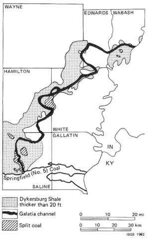
The Galatia channel in southeastern Illinois is the course of a stream that was flowing when the Springfield (No. 5) Coal was forming (Hopkins, Nance, and Treworgy, 1979). Roughly 1/2 to 3/4 mile wide, this channel has been traced about 150 miles southwestward from lndiana (Ault, Sullivan, and Tanner, 1980) through Wabash County, Illinois, to its outcrop in Saline County, Illinois (Hopkins, 1958) (fig. 10). The Galatia channel is filled mainly with siltstone and sandstone, averaging about 40 feet thick.
Just as the Herrin (No. 6) Coal thickens close to the Walshville channel, the Springfield (No. 5) Coal thickens toward the Galatia channel. It commonly exceeds 6 feet thick, reaching 10 feet thick in some places, although it is rarely thicker than 5 feet elsewhere. Belts of thick coal range from less than 1 mile to more than 6 miles wide along both sides of the channel (Hopkins, 1958).
The Springfield Coal is commonly split along the margins of the Galatia channel (figs. 10 and 11). It also may be overlain by the Dykersburg Shale, a gray silty shale or siltstone that bears the same relationship to the Galatia channel as the Energy Shale to the Walshville channel (fig. 3). Low- to medium-sulfur coal is found where the Dykersburg Shale is more than about 20 feet thick. Away from the channel, where thin Dykersburg Shale or black, fissile, marine shale overlies the Springfield Coal, the coal always contains about 2.5 percent sulfur or more.
Other channels
The Oraville channel apparently formed at the same time as the Murphysboro Coal Member in Jackson County, Illinois (Treworgy and Jacobson, in press). Along the borders of the sandstone-filled channel, the coal is commonly split. Near the channel, gray shale and siltstone similar to the Energy and Dykersburg Shales overlie low-sulfur coal deposits. Underground mining concentrated in this thick low-sulfur coal, despite widespread shale splits in the seam, which sometimes made mining uneconomical.
Large resources of the Seelyville (Indiana III) Coal have recently been mapped in east-central and southeastern Illinois. Splits are widespread. Locally, sandstone has replaced some coal. Channels probably developed contemporaneously with the Seelyville deposits but more drilling is needed to be certain (Treworgy, 1980; 1981).
Both the Colchester (No. 2) and Danville (No. 7) Coal Members are relatively low in sulfur where they are overlain by thick nonmarine gray shale or siltstone. Although these relationships suggest channels contemporaneous with peat formation, neither channels nor split coal have been reported in these seams. Possibly the channels ran beyond the present boundaries of the Illinois Basin Coal Field and were removed by post -Pennsylvanian erosion (Treworgy and Jacobson, in press).
Distinguishing channels from geological faults
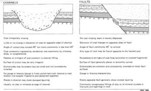
In mining operations, mistaking a channel for a geologic fault can be costly. Of course, channels contain no coal. Normally, coal is located at about the same elevation on opposite sides of a channel. The most economical way to mine across a channel is to drive a set of level entries at right angles to the course of the cutout. In a fault, however, the coal has been displaced either up or down, so the entries must be graded to rejoin the seam. In fact, before the entries can be planned, the amount and direction of throw on the fault must be determined (Nelson, 1981).
Features at the face can help miners decide whether a fault or a channel has been struck (fig. 12).
Previous experience in a particular mine and in the region will give clues about the nature of the obstruction in the coal. In some mines faults are encountered, but never channels; while in other mines the reverse is true. Most coal companies drill test holes before trying to mine across either a large fault or channel. Drilling can be done either from the surface or within the mine. Standard procedure includes collecting and examining cores, which should remove all doubt about the obstacle and indicate the proper course of action.
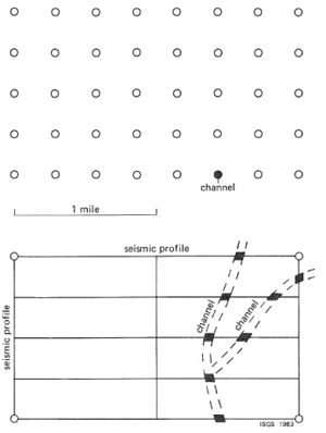
Locating channels through exploratory drilling can be a challenge. Narrow channels such as those in central Illinois may be missed. Even if a core shows channel-fill sediments in place of coal, the investigator will not know the width, extent, and direction of the cutout. Additional holes must be drilled around the one indicating a channel.
People logging exploratory cores must be alert to any indications of erosion close to the top of the coal which may signify the presence of a channel. Any sandstone or conglomerate should be suspect, especially if it shows a sharp or inclined contact with rocks or coal below. The presence of coal pebbles or stringers in conglomerate is an almost certain indication of erosion. Not all channels, however, contain coarse-grained sediments; some are filled with shale or siltstone. Careful correlation of the logs or nearby holes may show that key, persistent rock layers are missing unexpectedly and are replaced by shale or siltstone. Another useful technique is constructing maps of the thickness of sandstones. Abrupt thickening of a sandstone may indicate the presence of a channel.
High-resolution seismic profiling is a promising tool for locating channels and other disturbances. Seismic exploration can provide more information than drilling alone and cut costs by reducing the number of holes that must be drilled (fig. 13; Daly, 1979). Peabody Coal Company seismically located Anvil Rock channels and a 15-foot fault near its No. 10 Mine (Acker and Kumamoto, 1981). The presence of a fault and channels were confirmed with closely spaced drilling. Consolidation Coal Company also used seismic surveys to locate a channel near its Hillsboro Mine in Montgomery County, and later verified the channel by drilling (Coon et al., 1979).
Despite problems with identification, channels follow reasonably predictable patterns. In this respect they are easier to deal with than many other features discussed in this report. Many coal-seam disturbances (such as rolls and clastic dikes) are either localized, or vary greatly from site to site. They cannot be predicted ahead of the working face using existing techniques.
References
- Allgaier, G. J., and M. E. Hopkins, 1975, Reserves of the Herrin (No. 6) Coal in southeastern Illinois: lllinois State Geological Survey Circular 489, 31 p.
- Ault, C. H., D. M. Sullivan, and G. F. Tanner, 1980, Faulting in Posey and Gibson Counties, Indiana: Proceedings of the lndiana Academy of Science, v. 89, p. 275-289.
- Coon, J. B., J. T. Reed, W. L. Chapman, and D. E. Dunster, 1979, Surface seismic methods applied to coal -mining problems: AAPG Annual Convention, Houston, TX, April 1-4, 1979.
- Daly, T. E., 1979, High-resolution seismic methods in coal exploration: AAPG Annual Convention, Houston, TX, April 1-4, 1979.
- DeMaris, P. J., W. A. DiMichele, and W. J. Nelson, 1979, A compression flora associated with channel-fill sediments above the Herrin (No. 6) Coal: Abstract, Ninth l nternational Congress of Carboniferous Stratigraphy and Geology.
- Ferguson, H. F., 1967, Valley stress release in theAllegheny Plateau: Association, Engineering Geology Bulletin, v.4, no. 1, p. 63-69.
- Gluskoter, H. J., and M. E. Hopkins, 1970, Distribution of sulfur in lllinois coals, in Depositional Environments in Parts of the Carbondale Formation-Western and Northern Illinois: lllinois State Geological Survey Guidebook 8, p. 89-95.
- Hopkins, M. E., 1958, Geology and petrology of the Anvil Rock Sandstone of southern Illinois: Illinois State Geological Survey Circular 256, 49 p.
- Hopkins, M. E., R. B. Nance, and C. G. Treworgy, 1979, Mining geology of lllinois coal deposits, in Depositional and Structural History of the Pennsylvanian System of the lllinois Basin, Part 2: Field Trip 9, Ninth International Congress of Carboniferous Stratigraphy and Geology, p. 142-151.
- Hunt, S. R., R. A. Bauer, and P. B. DuMontelle, in press, Subsidence due to coal mining in the l llinois Basin Coal Field: U.S. Department of Energy, Final Contract Report ET-78-G-01-3085
- Nelson, W. J., 1981, Faults and their effect on coal mining in Illinois: Illinois State Geological Survey Circular 523, 38 p.
- Nelson, W. J., and R. B. Nance, 1980, Geological mapping of roof conditions, Crown I I Mine, Macoupin County, Illinois: Society of Mining Engineers of AIME, Preprint 80-308: lllinois State Geological Survey Reprint 1981A, 9 p.
- Payne, J. N., and G. H. Cady, 1944, Structure of Herrin (No. 6) Coal Bed in Christian and Montgomery Counties and adjacent parts of Fayette, Macon, Sangamon, and Shelby Counties: Illinois State Geological Survey Circular 105, 57 p.
- Piskin, K., and R. E. Bergstrom, 1975, Glacial drift in Illinois: thickness and character: lllinois Geological Survey Circular 490, 35 p.
- Potter, P. E., and R. F. Mast, 1963, Sedimentary structures, sand shape fabrics, and permeability: Journal of Geology, v. 71,
- no. 3, p. 441 -471.
- Simon, J. A., 1956, Sandstone cut-outs in Christian, Montgomery, Sangamon, and Macoupin Counties: lllinois State Geological Survey unpublished report, 3 p.
- Treworgy, C. G., 1980, Seelyville Coal-a major unexploited seam in Illinois: Abstracts, AAPG-SEPM-EMD Annual Convention, Denver, Colorado, June 8- 11, 1980, p. 130.
- Treworgy, C. G., 1981, The Seelyville Coal-a major unexploited seam in Illinois: l llinois State Geological Survey Mineral Notes 80, 1 1 p.
- Treworgy, C. G., and R. J. Jacobson, 1979, Paleoenvironments and distribution of low-sulfur coal in Illinois: Abstract, Ninth International Congress of Carboniferous Geology and Stratigraphy.
- Wang, F.-D., D. M. Ropchan, and M.-C. Sun, 1974, Structural analysis of a coal mine opening in clastic, multilayered material: U.S. Bureau of Mines Report of Investigations 7845, 36 p.
- Willman, H. B., and J. C. Frye, 1970, Pleistocene stratigraphy of Illinois: Illinois State Geological Survey Bulletin 94, 204 p.

