Circular 530 Miscellaneous Disturbances
| Geologic Disturbances in Illinois Coal Seams | ||||||||||
|---|---|---|---|---|---|---|---|---|---|---|
| Channels | Split Coal | Rolls | Limestone Bosses | Clay Dikes | White Top | Igneous Dikes | Joints | Coal Balls | Miscellaneous Disturbances | Acknowledgments |
Miscellaneous Disturbances
Some disturbances in coal seams and neighboring strata do not fit into the previous discussions. Either they are rare, localized phenomena or common features with minor influence on coal -mining operations.
Glacial Origin
Great continental ice sheets invaded Illinois at least four times during the Pleistocene Epoch-the most recent 2 million years or so of the earth's history. Glaciers advanced over northern and central Illinois; and at least one, the Illinoian, extended over almost all the area now underlain by coal -bearing strata. Probably the ice was several thousand feet thick over most of Illinois and exerted enormous pressure on the rocks beneath it. In some places, strata the weight and movement of ice.
In 1908, Udden described intense dislocations in the Springfield Coal near Peoria. The disturbances encountered in some shallow underground mines were also visible in outcrops and exposures along stream banks. Effects included (1) abrupt thinning or thickening of the seam, (2) sharply folded coal and adjoining strata, (3) rotated masses of bedrock-sometimes completely inverting the coal so that it rested above its roof shale, (4) doubled or tripled seams from layers broken and shoved over one another, (5) horizontal displacement of coal - bearing strata along large faults, and (6) crushed coal and rocks-sometimes a soft powder that could be scooped by hand. Some disturbances extended over hundreds of acres. Udden concluded that the pressure of movement of Pleistocene glaciers deformed the near the surface, including coal seams, were disturbed by coal and rocks.
Mining problems.
Glacial disturbances, which are near-surface features, are not usually encountered underground today because few modern operators mine as close to the surface as those early miners. Surface mines, however, may have to contend with glacial disruptions wherever the bedrock covering the coal is thin. Strip mining deformed coal, such as Udden described, would be expensive; yet much surface mining has taken place in Illinois, and few glacially caused disturbances have been encountered.
The Hill at Peabody Mine No. 10
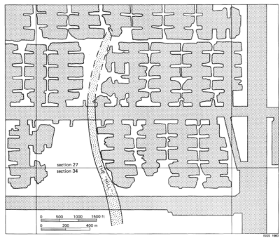
The hill at Peabody Mine No. 10 in Christian County is actually an elongate trough or valley in the Herrin (No. 6) Coal, trending roughly north-south for at least 5000 feet; its southern end has not been located (fig. 40). The coal in the trough is 20 to 30 feet lower than neighboring coal.
In cross section, the hill is quite symmetrical (fig. 41). Coal slopes gently into the trough on both sides for several hundred feet, then abruptly pitches downward at a 10- to 15-degree angle. The floor of the trough is roughly level and 150 to 200 feet wide. Also, the seam thickens as it dips into the trough, attaining up to twice its normal size. This thicker coal appears to contain more shaly partings than normal.
The roof strata also change in thickness and character in the hill (fig. 41). At the bottom of the valley, coal is overlain by 8 to 10 feet of gray shale (probably Energy Shale). The shale pinches out on the flanks of the trough, where the coal is overlain by black, fissile Anna Shale that thins as the coal rises. Away from the hill, the Brereton Limestone lies directly on the coal. A channel filled with Anvil Rock Sandstone follows the trough and has eroded the Anna Shale and Brereton Limestone. Although erosion of the coal was not observed, the base of the channel is scoured into the Energy Shale.
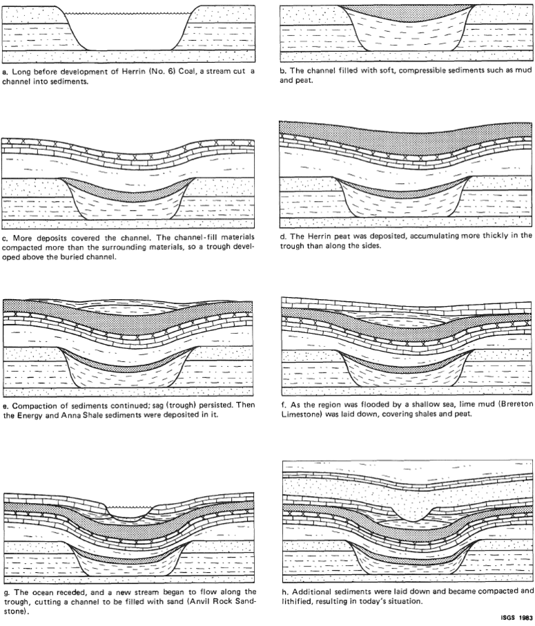
The hypothetical origin of the hill is shown in figure 42. A channel filled with easily compactable sediments such as mud and peat is believed to underlie the trough. As sediments compacted in the channel, an elongate depression formed, into which the Herrin Coal and overlying sediments were deposited more thickly than normal. After the Brereton Limestone formed, the depression persisted, providing a path for an Anvil Rock channel. To confirm this theory, drilling beneath the Herrin Coal in the trough is needed. Other coal-filled channels in Illinois include the Cardiff Coal in northeastern Livingston County (Cady, 1915), the Kerton Creek Coal in Fulton County (Wanless, 1957), and the Roodhouse Coal in Greene County (Willman et al., 1975). All are examples of thick canneloid coals localized in narrow channel-fill deposits. Similar occurrences also have been reported from coal mines in England (Elliott, 1965).
Mining problems.
Mining along the hill in Mine No. 10 is difficult despite the unusually thick coal found in it. Steep dips in the coal on the flanks of the trough, unstable roof in the Energy Shale, and seepage of groundwater from the Anvil Rock Sandstone increase the expense and trouble in mining. So the Peabody Coal Company has left some coal unmined.
Concretions
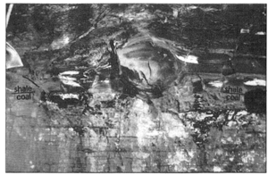
Large spherical or oval masses of hard rock in the shales overlying coal seams are known as concretions (fig. 43). Commonly composed of calcite (calcium carbonate) or siderite (iron carbonate), many concretions also contain pyrite and other sulfides. They can be as much as 3 or 4 feet in diameter and weigh hundreds of pounds. Concretions probably formed by chemical precipitation of minerals around a nucleus, such as a bit of organic matter in mud-before the mud hardened into shale.
Most concretions occur in black fissile shales such as the Anna Shale above the Herrin Coal, but they also appear in gray or mottled shales and siltstones. Since they are concentrated in the lowermost layers of the roof, they may protrude several inches into the coal (fig. 43).
Mining problems.
Large masses of intergrown concretions at the coal -roof contact can dull miner bits. Aside from this problem, concretions are a hazard in the roof because they generally are surrounded by slickensides that allow them to separate readily from the shale (Krausse et al., 1979a, 1979b). However, concretions rank fairly low on the list of geologic hazards with which coal miners contend.
Fossil Tree Stumps
Fossil tree stumps, sometimes called kettlebottoms, are found in the roof of a coal seam (fig 44). They are characteristic of gray shales and siltstones, such as the Dykersburg and Energy Shales, which formed from sediments that buried forests so rapidly the trees had no chance to decay. Usually only the bark or rind has been preserved as coal; the hollow centers of the stumps have been filled with mud and silt.
The central plug of shale separates easily from the coalified bark and can be a minor hazard in underground operations. Where fossil tree stumps are numerous, they make the upper surface of the coal slightly irregular; but aside from the danger of their falling from the roof, the do not significantly influence coal mining.
References
- Cady, G. H., 1915, Coal resources of District I (longwall): Illinois Geological Survey Cooperative Coal Mining investigations Bulletin 10, 149 p.
- Elliott, R. E., 1965, Swilleys in the coal measures of Nottinghamshire interpreted as palaeoriver courses: Mercian Geologist, v. 1, p. 133-142.
- Krausse, H.-F., H. H. Damberger, W. J. Nelson, S. R. Hunt, C. T. Ledvina, C. G. Treworgy, and W. A. White, 1979a, Roof strata of the Herrin (No. 6) Coal and associated rock in Illinois-a summary report: Illinois State Geological Survey Mineral Notes 72, 54 p.
- Krausse, H.-F., H. H. Damberger, W. J. Nelson, S. R. Hunt, C. T. Ledvina, C. G. Treworgy, and W. A. White, 1979b, Engineering study of structural geologic features of the Herrin (No. 6) Coal and associated rock in Illinois. Volume 2: Illinois State Geological Survey, Final Contract Report to U.S. Bureau of Mines H0242017, 205 p.
- Wanless, H. R., 1957, Geology and mineral resources of the Beardstown, Glasford, Havana, and Vermont Quadrangles: Illinois State Geological Survey Bulletin 82, 233 p.
- Willman, H. B., E. Atherton, T. C. Buschbach, C. Collinson, J. C. Frye, M. E. Hopkins, J. A. Lineback, and J. A. Simon, 1975, Handbook of Illinois stratigraphy: Illinois State Geological Survey Bulletin 95, 261 p.

