Mine Index Number: 0037
| Company Name:
|
Peabody Coal Company
|
| Mine Name:
|
Peabody No. 59 Mine
|
| Start Date:
|
1884
|
End Date:
|
September 1951
|
| Type of Mine:
|
Underground
|
| Total acres shown:
|
4,121
|
| Acres after map date:
|
|
General Area of mining acres shown:
|
|
|
|
Shaft, Slope, Drift or Tipple Location(s)
| Type
|
County
|
Township-Range
|
Section
|
Part Section
|
| Main shaft
|
Sangamon
|
16N 5W
|
13
|
2000 FSL, 115 FWL
|
| Air shaft
|
Sangamon
|
16N 5W
|
13
|
2240 FSL, 1040 FWL
|
| Air shaft
|
Sangamon
|
16N 4W
|
16
|
1220 FSL, 440 FWL
|
| Air shaft
|
Sangamon
|
16N 4W
|
18
|
SE NW SE
|
Geology
Geological Problems Reported
The roof was a very black, sheety shale that had many concretions of all sizes, up to several feet in diameter. The concretions frequently extended down into the coal. An entry in the mine notes indicate that pillars were robbed or made as small as possible so that the roof often caved after the rooms were worked out. The coal was very clean but had some clay veins and horsebacks and a very few plates and horizontal bands of pyrite. Several of the horsebacks cut entirely through the coal and ranged from 3 to 15 feet wide. The floor was a dark gray fire clay that heaved slightly.
Production
| Company
|
Mine Name
|
Date
|
Production (tons)
|
|
|
|
|
|
| Total Production: 20,679,690
|
Production Notes
Coal Report production (if available)
Sources of Data
| Microfilm, document 351209
|
9-21-1951
|
1:4800
|
1:9600
|
Final
|
| State archive, IL_451
|
9-21-1951
|
1:2400
|
1:2400
|
Final
|
Annotated Bibliography (Data source - brief description of information)
| Coal Reports - Production, ownership, years of operation.
|
| Directory of Illinois Coal Mines (Sangamon County) - Mine names, mine index, ownership, years of operation.
|
| ENR Document 85/01 - Mining method.
|
| Mine notes (Sangamon County) - Mine type, shaft location, seam, depth, thickness, geologic problems.
|
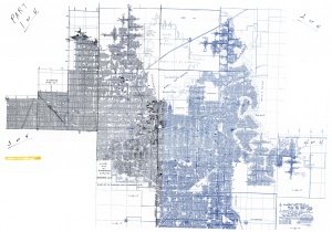
| Microfilm map, document 351209, reel 03134, frames 395-399 - Shaft locations, mine outline.
|
| State achive, IL_451, map of Peabody No. 57 mine (mine index 37), courtesy of Robert Gibson, IDNR - Air shaft (central).
|
Mine Notes
Mine Images
Company: IL-451
Map Date: 9-21-1951
Coal Co.: Peabody Coal Co.
Mine Name: Peabody No. 59 Mine
Image Credit: Illinois Department of Natural Resources - Office of Mines and Minerals
Full Res Download
Photographs
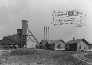
Caption: Springfield Colliery Company, Sangamon County. The A-frame structure in the center of the photography is the headframe, supporting cables from the engine house on the right. The shaft is below the tower. The structure on the left is the tipple, or loading platform, and the sorting shed is above the tipple.
Credit: Illinois State Geological Survey
Date: Circa 1910


