Mine Index Number: 0121
| Company Name:
|
Utility Coal Company
|
| Mine Name:
|
Bissell Mine
|
| Start Date:
|
1892
|
End Date:
|
September 1923
|
| Type of Mine:
|
Underground
|
| Total acres shown:
|
412
|
| Acres after map date:
|
5
|
General Area of mining acres shown:
|
|
|
|
Shaft, Slope, Drift or Tipple Location(s)
| Type
|
County
|
Township-Range
|
Section
|
Part Section
|
| Main shaft
|
Sangamon
|
16N 4W
|
8
|
SW NW SW
|
| Air shaft
|
Sangamon
|
16N 4W
|
8
|
SW NW SW
|
Geology
| Springfield
|
234
|
5.0
|
6.0
|
5.5
|
MRP
|
Geological Problems Reported
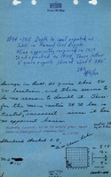
The roof was 1.5 to 4 ft of black shale topped by 0 to 4 ft of limestone cap rock. The shale contained concretions. However, it was noted that the roof conditions were good and little timbering was required. Numerous horsebacks were seen, extending down into the coal from the roof. The coal contained a 1.5 to 2 inch pyrite band found locally at the top of the coal. The floor was over 6 ft of fire clay. The operators had some problem with squeezes so that double-track width entries could rarely be maintained. The floor heaved after standing in abandoned workings.
Production
| Company
|
Mine Name
|
Date
|
Production (tons)
|
|
|
|
|
|
| Total Production: 2,249,202
|
Production Notes
Coal Report production (if available)
Sources of Data
| Company, state archive
|
3-1-1923
|
1:2400
|
1:2400
|
Not final
|
Annotated Bibliography (Data source - brief description of information)
| Coal Reports - Production, ownership, years of operation.
|
| Directory of Illinois Coal Mines (Sangamon County) - Mine names, mine index, ownership, years of operation.
|
| Mine notes (Sangamon County) - Mine type, shaft location, seam, depth, thickness.
|
| Company map, state archive, PB_1089 - Shaft locations, mine outline, mining method.
|
Mine Notes
Mine Images
Company: PB_1089
Map Date: 3-1-1923
Coal Co.: Bissell Coal Co.
Mine Name: Clear Lake Mine
Image Credit: Illinois Department of Natural Resources - Office of Mines and Minerals
Full Res Download
Photographs
Additional Notes
Additional Notes