Mine Index Number: 0122
| Company Name:
|
Brewerton Coal Company
|
| Mine Name:
|
Brewerton No. 81 Mine
|
| Start Date:
|
1901
|
End Date:
|
December 1938
|
| Type of Mine:
|
Underground
|
| Total acres shown:
|
765
|
| Acres after map date:
|
25
|
General Area of mining acres shown:
|
|
|
|
Shaft, Slope, Drift or Tipple Location(s)
| Type
|
County
|
Township-Range
|
Section
|
Part Section
|
| Main shaft
|
Sangamon
|
15N 5W
|
11
|
650 FSL, 440 FWL
|
Geology
| Springfield
|
235
|
5.0
|
6.0
|
5.5
|
RPP
|
Geological Problems Reported
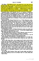
The roof was 8 inches to 3.5 ft of black shale that required heavy timbering (every 4 ft) and usually came down anyway, especially near the horsebacks. If the shale was less than 1.5 ft thick, it was pulled down by the miners. In some areas, large dark calcareous concretions were present. Above the shale was a 6 inch to 4 ft limestone that had an uneven contact with the shale beneath. Occasional rolls and inverted conical projections of the limestone protruded down into the coal. Clay horsebacks were “everywhere”, and could be expensive to cut through, especially if they were hard. Charcoal and pyrite were present in lenses and bands in the upper part of the coal seam throughout the mine. The underclay was about 12 ft thick and heaved 4 to 5 inches, but no serious squeezes took place.
Production
| Company
|
Mine Name
|
Date
|
Production (tons)
|
|
|
|
|
|
| Total Production: 4,099,901
|
Production Notes
Coal Report production (if available)
Sources of Data
| Microfilm, document 351217
|
2-22-1938
|
1:2400
|
1:5196
|
Not final
|
Annotated Bibliography (Data source - brief description of information)
| Coal Reports - Production, ownership, years of operation.
|
| Directory of Illinois Coal Mines (Sangamon County) - Mine names, mine index, ownership, years of operation.
|
| ENR Document 85/01 - Mining method.
|
| Mine notes (Sangamon County) - Mine type, shaft location, seam, depth, thickness, geologic problems.
|
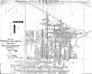
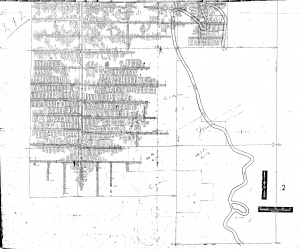
| Microfilm map, document 351217, reel 03134, frames 409-410 - Shaft locations, mine outline.
|
Mine Notes
Mine Images
Microfilm: 351217
Map Date: 2-22-1938
Coal Co.: Brewerton Coal Co.
Mine Name: Brewerton No. 81 Mine
Full Res Download
Microfilm: 351217
Map Date: 3-22-1938
Coal Co.: Brewerton Coal Co.
Mine Name: Brewerton No. 81 Mine
Photographs
Additional Notes


