Mine Index Number: 0209
| Company Name:
|
Sparta Coal and Mining Company
|
| Mine Name:
|
Sparta No. 4 Mine
|
| Start Date:
|
1901
|
End Date:
|
March 1929
|
| Type of Mine:
|
Underground
|
| Total acres shown:
|
553
|
| Acres after map date:
|
45
|
General Area of mining acres shown:
|
|
|
|
Shaft, Slope, Drift or Tipple Location(s)
| Type
|
County
|
Township-Range
|
Section
|
Part Section
|
| Main shaft (7 x 14 ft)
|
Randolph
|
5S 5W
|
16
|
NE NE NW
|
| Air shaft
|
Randolph
|
5S 5W
|
9
|
SW SE SW
|
Geology
| Herrin
|
80
|
4.5
|
6.5
|
5.0
|
MRP
|
Geological Problems Reported
The cap rock was limestone that averaged 5 feet thick. The limestone was reported to range up to 20 feet thick, but pinched out in the northern and eastern parts of the mine. The immediate roof above the coal was generally 1.5 to 4 feet of shale, with lenses of draw slate up to 1 foot thick between the shale and coal. In one part of the mine, concretions were numerous and were usually taken down. Some slips were noted, but they did not contribute to roof problems. On the eastern side of the mine, a pre-glacial valley was encountered, where the coal was eroded or not deposited. The blue band was persistent throughout the mine. Other impurities in the coal included pyrite, clay, and charcoal. The underclay averaged 18 inches thick and heaved readily, even in newly opened parts of the mine.
Production
| Company
|
Mine Name
|
Date
|
Production (tons)
|
|
|
|
|
|
| Total Production: 3,423,447
|
Production Notes
Coal Report production (if available)
Sources of Data
| State archive, IL_1031
|
4-1927
|
1:2400
|
1:1800
|
Not final
|
Annotated Bibliography (Data source - brief description of information)
| Coal Reports - Production, ownership, years of operation.
|
| Directory of Illinois Coal Mines (Randolph County) - Mine names, mine index, ownership, years of operation.
|
| Mine notes (Randolph County) - Mine type, shaft location and size, seam, depth, thickness, geologic problems.
|
| State archive, IL_1031, courtesy of Robert Gibson, IDNR - Shaft locations, mine outline, mining method.
|
Mine Notes
Mine Images
Photographs
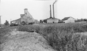
Caption: Swamp in a typical sag in Randolph County where a 6 foot coal is being mined at depth of 150 feet. The rooms are on 50 foot centers; pillars 18 feet.
Credit: Illinois State Geological Survey
Date: Pre-1914
Publication: Fig. 27 Cooperative Bulletin 17 – Subsidence in Illinois
Library No.: M-826

