Mine Index Number: 0442
| Company Name:
|
Clover Leaf Coal Company
|
| Mine Name:
|
Clover Leaf No. 4 Mine
|
| Start Date:
|
1906
|
End Date:
|
March 1924
|
| Type of Mine:
|
Underground
|
| Total acres shown:
|
399
|
| Acres after map date:
|
|
General Area of mining acres shown:
|
|
|
|
Shaft, Slope, Drift or Tipple Location(s)
| Type
|
County
|
Township-Range
|
Section
|
Part Section
|
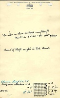
| Main shaft (11'x22')
|
Montgomery
|
7N 3W
|
3
|
NE SE NE
|
| Air shaft This air shaft was completed in 1913. The mine was connected to Clover Leaf No. 1 Mine (mine index 3001), whichsufficed for the initial ventilation and escape way.
|
Montgomery
|
7N 3W
|
3
|
SW SE NE
|
Geology
| Herrin
|
510-544
|
|
|
6.0-8.0
|
RPP
|
Geological Problems Reported
The roof was a massive black shale, with sandstone above. Rolls were present in the mine. The source map shows many unmined areas within the mine outline. The reason these areas were not mined is not specified in the mine notes or on the source map, but water-bearing sands above the roof shale could contribute to roof problems.
Production
| Company
|
Mine Name
|
Date
|
Production (tons)
|
|
|
|
|
|
| Total Production: 1,838,857
|
Production Notes
Coal Report production (if available)
Sources of Data
| Microfilm, document 352580
|
7-1923
|
1:2400
|
1:4800
|
Not final
|
| State archive, MSHA_412_04
|
7-14-1915
|
1:1200
|
1:1430
|
Not final
|
| State archive, IL_2441_01
|
4-1924
|
1:2400
|
1:2400
|
Final
|
Annotated Bibliography (Data source - brief description of information)
| Coal Reports - Production, ownership, years of operation, mine type, depth, thickness.
|
| Directory of Illinois Coal Mines (Montgomery County) - Mine names, mine index, ownership, years of operation.
|
| Mine notes (Montgomery County) - Shaft location, seam, thickness, geologic problems.
|
| Microfilm map, document 352580, reel 03139, frame 377 - Mine outline (southwestern), geologic problems.
|
| State Archive, MSHA_412, courtesy of Robert Gibson, IDNR - Mine outline (northern half), mining method.
|
| State Archive, IL_2441_01, courtesy of Robert Gibson, IDNR - Shaft locations, mine outline (southern half), mining method.
|
Mine Notes
Mine Images
Photographs