Mine Index Number: 0792
| Company Name:
|
Senior Hill Coal Company
|
| Mine Name:
|
A-kay Mine
|
| Start Date:
|
1893
|
End Date:
|
August 1948
|
| Type of Mine:
|
Underground
|
| Total acres shown:
|
337
|
| Acres after map date:
|
|
General Area of mining acres shown:
|
|
|
The southern part of the western side of the mine was later surface-mined by River King No. 6 Mine (mine index 0934).
|
Shaft, Slope, Drift or Tipple Location(s)
| Type
|
County
|
Township-Range
|
Section
|
Part Section
|
| Main shaft (6.5'x13')
|
St. Clair
|
3S 6W
|
7
|
SE NW SW
|
| Air shaft
|
St. Clair
|
3S 6W
|
7
|
NE SW SW
|
Geology
Geological Problems Reported
The western side of the southernmost extensions are labeled “caved” and some are designated with “water”. Old works were encountered near the center of the mine, on the southern side between the east and west “wings” of mining. This area has been designated with a large general area of mining on the accompanying map. The old works may have been from the early years of this mine or a different operator.
Production
| Company
|
Mine Name
|
Date
|
Production (tons)
|
|
|
|
|
|
| Total Production: 2,042,119
|
Production Notes
Coal Report production (if available)
Sources of Data
| Company, state archive IL_117
|
2-24-1953
|
1:2400
|
1:2400
|
Final
|
Annotated Bibliography (Data source - brief description of information)
| Coal Reports - Production, ownership, years of operation.
|
| Directory of Illinois Coal Mines (St. Clair County) - Mine names, mine index, ownership, years of operation.
|
| Mine notes (St. Clair County) - Mine type, shaft location, shaft size, seam, depth, thickness.
|
| Company map, state archive, IL_117 - Shaft locations, mine outline, mining method, geologic problems.
|
Mine Notes
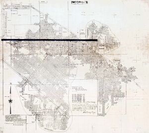
Mine Images
State Archive: IL_117
Map Date: 2-24-1953
Coal Co.: Senior Hill Coal Company
Mine Name: A-kay Mine
Full Res Download
Photographs


