Mine Index Number: 0877
| Company Name:
|
Consol Energy, Inc.
|
| Mine Name:
|
Rend Lake Mine
|
| Start Date:
|
1967
|
End Date:
|
2002
|
| Type of Mine:
|
Underground
|
| Total acres shown:
|
9,845
|
| Acres after map date:
|
|
General Area of mining acres shown:
|
|
|
|
Shaft, Slope, Drift or Tipple Location(s)
| Type
|
County
|
Township-Range
|
Section
|
Part Section
|
| Main production shaft
|
Jefferson
|
4S 2E
|
30
|
SE NE SW
|
| Air, man and material shaft
|
Jefferson
|
4S 2E
|
30
|
NW SE SW
|
Geology
Geological Problems Reported
Faults were noted, with 3 to 13 feet displacement. The mine had a wet area that was delineated by the company by a “drip line” on their mine maps. Some saline water came from layers above the shale and dripped down the pillars into the mine. Another source of water was probably Rend Lake, as one of the test holes for the mine, drilled in 1918 and later submerged, penetrated one area noted for water problems. In other areas, water was said to seep up from the floor. The roof was a weak gray shale that came down readily, with a silty gray shale above that. Roof falls were more common near the top of seam undulations. A large roll was noted that crossed three entries. Sandstone-filled rolls were seen in this mine. One such roll cut out 5 feet of coal, and a different roll cut out 2 feet of coal and was 6 feet wide. However, most rolls were not persistent. The seam contained pyrite along cleat fillings and in en echelon fractures. Some pyrite occurred as thin laminations, with pyrite-filled “goat beards” above and below the laminations. (In this mine, “goat beards” was used for bundles of extension fractures.) When using the continuous mining machine, the company attempted to keep a 7-foot mining height, which sometimes involved leaving 1 foot of bottom coal and some top coal. The bottom coal was left because of the water, which would have turned the floor into mud and created a difficult surface for the machines. Some areas of the mine had split coal. The largest split was in the upper part of the seam, and was 0.1 to 0.4 feet thick.
Production
| Company
|
Mine Name
|
Date
|
Production (tons)
|
|
|
|
|
|
| Total Production: 81,256,213
|
Production Notes
Coal Report production (if available)
Sources of Data
| Company, 6-355
|
1-1-2003
|
1:12000
|
1:12000
|
Final
|
Annotated Bibliography (Data source - brief description of information)
| Coal Reports - Production, ownership, years of operation, depth.
|
| Directory of Illinois Coal Mines (Jefferson County) - Mine names, mine index, ownership, years of operation.
|
| Mine notes (Jefferson County) - Mine type, shaft locations, seam, thickness, geologic problems.
|
| Company map, Coal Section files, 6-355 - Shaft locations, mine outline, mining method.
|
Mine Notes
Mine Images
Photographs
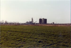
Caption: Surface works of Inland Steel Co. Mine No. 1, Jefferson County; as viewed from southeast. Photo by John Nelson, March 1981
Credit: Illinois State Geological Survey
Date: March 1981
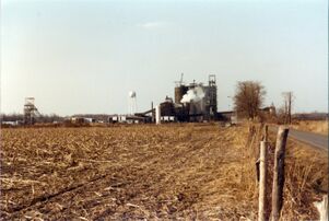
Caption: View of Inland Steel's tipple from the south
Date: 1981
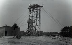
Caption: Sinking of Inland Steel's coal hoist shaft.
Date: June 30, 1966
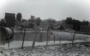
Caption: Sinking of Inland Steel's man and material shaft.
Date: June 26, 1966

![[[:Rend Lake|Rend Lake]]](https://wikiimage.isgs.illinois.edu/ilmines/jefferson/thumbnails/m0877_6_355_2003_th.jpg)
